Hermanus

Last updated
Hermanus
Hermanus panoramic view-002.jpg
View of Hermanus from Rotary Way.jpg
Hermanus Old Harbour.jpg
Hermanus Coastline and City View.jpg
Clockwise from top: Panoramic view of Hermanus, the Old Harbour, Hermanus coastline, view from Rotary Way.
South Africa Western Cape location map.svg
Red pog.svg
Hermanus
South Africa adm location map.svg
Red pog.svg
Hermanus
Africa location map.svg
Red pog.svg
Hermanus
Coordinates: 34°25′S19°15′E / 34.417°S 19.250°E / -34.417; 19.250 Coordinates: 34°25′S19°15′E / 34.417°S 19.250°E / -34.417; 19.250
Country South Africa
Province Western Cape
District Overberg
Municipality Overstrand
Area
  Total17.03 km2 (6.58 sq mi)
Population
 (2011)
  Total5,610
  Density330/km2 (850/sq mi)
Racial makeup (2011)
   White 80.66%
   Black African 12.25%
   Colored 5.65%
   Indian/Asian 0.78%
  Other0.66%
First languages (2011)
   Afrikaans 44.68%
   English 31.76%
   Xhosa 0.64%
   Sotho 0.27%
  Other22.64%
Time zone UTC+2 (SAST)
Postal code (street)
7200
PO box
7200
Area code 028
View of Hermanus and Grotto Beach from Rotary Way. View of Hermanus and Grotto Beach from Rotary Way.jpg
View of Hermanus and Grotto Beach from Rotary Way.

Hermanus (originally called Hermanuspietersfontein, but shortened in 1902 as the name was too long for the postal service [1] ), is a town on the southern coast of the Western Cape province of South Africa. It is known for Southern Right whale watching during the southern winter to spring seasons, and is a popular retirement location.

Contents

History

Hermanus Pieters (ca.1778–1837) was a Dutch teacher who arrived in Cape Town in 1815. He was recruited by Dutch-speaking farmers who disliked that English was the only language used in all government schools. He settled in Caledon, but taught Dutch to farmers in a wide area around that town, including the Hemel-en-Aarde Valley. He often vacationed at the spring ("fontein") in present-day Hermanus, where he fished and grazed his sheep, the place eventually became known as “Hermanus Pieters se Fonteyn”. He died before the village Hermanuspietersfontein existed. 65 years after his death the postmaster decided to abbreviate the name to Hermanus. [1]

The parents of Roger Bushell, leader of the "Great Escape" (the escape by Allied airmen from Stalag Luft III in World War II), retired in Hermanus after World War II, and are buried there. Bushell's name is one of those commemorated on the war memorial.[ citation needed ]

Location

Hermanus lies along Walker Bay on the south coast of the Western Cape. It is located about 115 km southeast of Cape Town and is connected to the Mother City by the R43 highway (or coastal R44 scenic route) and N2 motorway. The R43 continues to Cape Agulhas, the most southerly point of Africa. Hermanus is 40 km from Gansbaai, a spot where people can dive amongst the great white sharks.[ citation needed ] It is also notable that Hermanus still boasts a historic railway station building without a railway line. The founders of the town decided not to lay any tracks as this would have made Hermanus more commercial and felt that Hermanus needed to stay a small fisherman's village. To this day the locals still refer to it as "the village."

The town of Vermont borders Hermanus to its east.

Sandbaai lies on the coast at the entrance to the Hemel-en-Aarde (Heaven and Earth) Valley. It is the most recently developed and fastest-growing residential area of Greater Hermanus. [2] Zwelihle, designated a "black" area by the apartheid era government, is a residential area that consists mainly of shacks. [2] Following the COVID 19 pandemic the town has emerged as a popular destination for very wealthy South Africans to move to. [3]

Climate

Hermanus is classified as having a warm-summer Mediterranean climate (Köppen). [4] It receives roughly 520 mm of rain per annum, the majority of which falls during the winter months of June to August in the form of frontal precipitation. Average midday temperatures range from 25 °C in February to 16 °C in July. [4] Extremes above 30 °C and under 10 °C are not uncommon. Summer and Winter months are characterised by strong south-easterly and north-westerly winds respectively.[ citation needed ]

Facilities

The Space Science Directorate of the South African National Space Agency, previously the Hermanus Magnetic Observatory (HMO), is a research facility of the National Research Foundation and forms part of the worldwide network which monitors variations of the earth's magnetic field.[ citation needed ]

Environment

Beaches

Grotto Beach near Hermanus Grotto Beach - Hermanus.jpg
Grotto Beach near Hermanus

Grotto Beach is the largest beach in Hermanus and has also been proclaimed a blue Flag beach. Blue flag beaches meet international environment, safety and management criteria. [5] Other beaches with Blue Flag status include Voëlklip, Onrus, Kammabaai, Langbaai, and Hawston. The rugged coastline also hosts many other smaller beaches, coves and tidal pools.[ citation needed ]

Floral diversity

Hermanus is in the Cape Floristic Region and thus has one of the highest plant diversity levels in the world. [6] The principal vegetation type of this region is fynbos, a mixture of evergreen shrub-like plants with small firm leaves. In the local Fernkloof Nature Reserve, 1,474 plant species have thus far been collected and identified. [7]

Bird watching

Over 100 varieties of bird species reside in the Greater Hermanus area. Species such as the Orange-breasted Sunbird, the Cape Sugarbird, Victorin's Warbler, and other rare animals, make Hermanus a destination for bird enthusiasts. [8]

Whales and whale-spotting

"Whale Crier" (recently retired Wilson Salukazana) Hermanus2.jpg
"Whale Crier" (recently retired Wilson Salukazana)

The town is noted for the presence of whales that often swim within sight of the coastline of the town. Although the Southern Right whale is the most prolific species in Hermanus bay, it is not the only species in the area. The whales can be seen from the cliffs all along the coast from as early as June and usually depart in early-December. They were once hunted in the nearby town of Betty's Bay, but are now protected. The Old Harbour Museum contains several exhibitions that explain the local whaling industry, and the De Wetshuis Photo Museum houses an exhibition of photos by T. D. Ravenscroft that depicts the history of Hermanus. The Whale Museum houses a skeleton of a whale and shows an audio-visual presentation of whales and dolphins twice daily.[ citation needed ]

Visitors can watch whales from the cliff-tops, from the air or via boats. Since August 1992, Hermanus has had the world's only whale crier, the first being Pieter Classen 1992-1998, then Wilson Salukazana 1998-2006, [9] and Zolile Baleni since April 2006, [10] who sounds his kelp horn to announce where whales have been sighted. In 2005, Zakes Mda wrote the novel The Whale Caller in which the Whale Crier of Hermanus is the main character, a man who gets enthralled by a southern right whale he names Sharisha. The book was adapted into a 2016 movie by the same name.[ citation needed ]

Whale festival

Hermanus hosts an annual Hermanus Whale Festival at the end of September, [11] to celebrate the calving and mating season. Eco-Tourism is the main theme of the Hermanus whale festival with the Eco-Marine Village. Residents and visitors celebrate the migration of Southern Right Whales and other marine wildlife with ocean-themed activities and exhibitions, emphasizing education and environmentally responsible adventures and activities. Prior to this main whale festival, a Kalfiefees (or Calf Festival) is held, to welcome the first whales (usually in August). Both festivals are characterized by food and craft stalls, environmental presentations, and South African drama productions.[ citation needed ]

Notable residents

See also

Related Research Articles

<span class="mw-page-title-main">Cape Town</span> Legislative capital of South Africa

Cape Town is one of South Africa's three capital cities, serving as the seat of the Parliament of South Africa. It is the legislative capital of the country, the oldest city in the country, and the second largest. Colloquially named the Mother City, it is the largest city of the Western Cape province, and is managed by the City of Cape Town metropolitan municipality. The other two capitals are Pretoria, the executive capital, located in Gauteng, where the Presidency is based, and Bloemfontein, the judicial capital in the Free State, where the Supreme Court of Appeal is located.

<span class="mw-page-title-main">Dhilba Guuranda–Innes National Park</span> Protected area in the Yorke Peninsula, South Australia

Dhilba Guuranda–Innes National Park, formerly Innes National Park, is an IUCN-designated protected area in the Australian state of South Australia located on the southwest tip of Yorke Peninsula about 300 kilometres (190 mi) west of the state capital of Adelaide. It is a popular destination for camping, bushwalking, fishing, surfing and scuba diving.

<span class="mw-page-title-main">Whale watching</span> Viewing cetaceans in their habitats

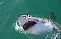
Whale watching is the practice of observing whales and dolphins (cetaceans) in their natural habitat. Whale watching is mostly a recreational activity, but it can also serve scientific and/or educational purposes. A study prepared for International Fund for Animal Welfare in 2009 estimated that 13 million people went whale watching globally in 2008. Whale watching generates $2.1 billion per annum in tourism revenue worldwide, employing around 13,000 workers. The size and rapid growth of the industry has led to complex and continuing debates with the whaling industry about the best use of whales as a natural resource.

<span class="mw-page-title-main">Southern right whale</span> Species of mammal

The southern right whale is a baleen whale, one of three species classified as right whales belonging to the genus Eubalaena. Southern right whales inhabit oceans south of the Equator, between the latitudes of 20° and 60° south. In 2009 the global population was estimated to be approximately 13,600.

<span class="mw-page-title-main">Eastern Cape</span> Province in South Africa

The Eastern Cape is one of the provinces of South Africa. Its capital is Bhisho, but its two largest cities are East London and Port Elizabeth.

<span class="mw-page-title-main">Plettenberg Bay</span> Place in Western Cape, South Africa

Plettenberg Bay, nicknamed Plet or Plett, is the primary town of the Bitou Local Municipality in the Western Cape Province of South Africa. As of the census of 2001, there were 29,149 population. It was originally named Bahia Formosa by early Portuguese explorers and lies on South Africa's Garden Route 210 km from Port Elizabeth and about 600 km from Cape Town.

<span class="mw-page-title-main">Paternoster, South Africa</span> Place in Western Cape, South Africa

Paternoster is one of the oldest fishing villages on the West Coast of South Africa. It is situated 15 km north-west of Vredenburg and 145 km north of Cape Town, at Cape Columbine between Saldanha Bay and St Helena Bay. The town covers an area of 194.8 hectare and has approximately 1883 inhabitants.
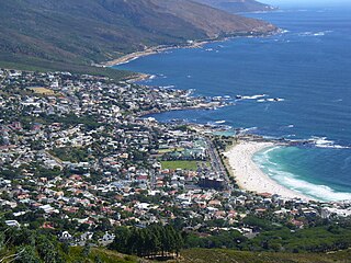
<span class="mw-page-title-main">Swellendam</span> Town in Western Cape, South Africa

Swellendam is the fifth oldest town in South Africa, a town with 17,537 inhabitants situated in the Western Cape province. The town has over 50 provincial heritage sites, most of them buildings of Cape Dutch architecture. Swellendam is situated on the N2, approximately 220 km from both Cape Town and George.

<span class="mw-page-title-main">Gqeberha</span> City in Eastern Cape, South Africa

Gqeberha, formerly Port Elizabeth, and colloquially often referred to as P.E., is a major seaport and the most populous city in the Eastern Cape province of South Africa. It is the seat of the Nelson Mandela Bay Metropolitan Municipality, South Africa's second-smallest metropolitan district by area size. It is the sixth-most populous city in South Africa and is the cultural, economic and financial centre of the Eastern Cape.

<span class="mw-page-title-main">Walker Bay</span> Body of water

Walker Bay is a large bay located in the south-western Western Cape province of South Africa. It is the next major bay between False Bay near Cape Town and Cape Agulhas to the south-east. The bay is famous for having some of the best land based whale-watching in the world, which a town on its shores, Hermanus, has become famous for. Southern right whales visit the bay in the winter and spring months.

<span class="mw-page-title-main">Sodwana Bay</span> Bay of the Indian Ocean on the northern KwaZulu-Natal coast of South Africa

Sodwana Bay is a bay in South Africa on the KwaZulu Natal north coast, between St. Lucia and Lake Sibhayi. It is in the Sodwana Bay National Park, and the Maputaland Marine Reserve, and is a popular recreational diving destination. The term is commonly used to refer to both the marine reserve and the terrestrial park, as well as the geographical bay.

<span class="mw-page-title-main">Kleinmond</span> Town in Western Cape, South Africa

Kleinmond is a small coastal town in the Overberg region of the Western Cape province, South Africa. It is situated inside a UNESCO-declared biosphere about 90 km east of Cape Town between Betty's Bay and Hermanus. The town's name, meaning "small mouth" in Afrikaans, refers to its location at the mouth of the Bot River lagoon. Stone ax heads found in the area indicate that people already lived in the vicinity of nearby Hangklip 20,000 years ago. Information about the area has existed in writing since the seventeenth century.

<span class="mw-page-title-main">St James, Cape Town</span> Seaside suburb of Cape Town, Western Cape, South Africa

St James is a seaside village on the Cape Peninsula, South Africa, situated on the False Bay coast between Muizenberg and Kalk Bay. The village is situated between the rocky shore and a steep mountain, and measures about 200m by 2 km. Its name derives from the early St James Catholic Church, built circa 1880. Most of the suburb was built between 1910 and 1950, after the railway line was built connecting Cape Town to False Bay.

Saint Helena Bay is a settlement in West Coast District Municipality in the Western Cape province of South Africa.

The marine protected areas of South Africa are in an area of coastline or ocean within the exclusive economic zone (EEZ) of the Republic of South Africa that is protected in terms of specific legislation for the benefit of the environment and the people who live in and use it. An MPA is a place where marine life can thrive under less pressure than unprotected areas. They are like underwater parks, and this healthy environment can benefit neighbouring areas.


The Betty's Bay Marine Protected Area is part of the Kogelberg Biosphere Reserve. It is about 29 km south-east of Gordon's Bay and approximately 37 km north-west of Hermanus on the south-western coast of the Western Cape. It is in the Atlantic Ocean immediately adjacent to the town of Betty's Bay, in the Overstrand Municipal area.

<span class="mw-page-title-main">De Hoop Marine Protected Area</span> Marine conservation area on the south coast of the Western Cape of South Africa

The De Hoop Marine Protected Area lies between Arniston and the mouth of the Breede River on the south coast of South Africa adjacent to the De Hoop Nature Reserve. The MPA is 51 kilometres long, and extends 5 nautical miles to sea. The whole MPA is a restricted area and is part of the migratory route and calving area for Southern right whales. The area protects habitats for several economically important inshore reef fish species, and ensures the retention of marine biomass in this part of the coast. The limestone coastline is includes archaeological sites and middens that date back centuries. The MPA is close to the Breede River estuary and, provides protection for species like cob that breed in the estuary and then return to the ocean.

The Goukamma Marine Protected Area is an inshore conservation region near Knysna in the Western Cape province in the territorial waters of South Africa

The Hluleka Marine Protected Area is an inshore conservation region in the territorial waters of the Eastern Cape province of South Africa.

The Walker Bay Whale Sanctuary Marine Protected Area is an inshore conservation region in the territorial waters of South Africa in the Western Cape province between Hermanus and Gansbaai.

References

  1. 1 2 Hermanus Pieters: The Beginnings of Hermanus Archived 2022-01-28 at the Wayback Machine at the official
  2. 1 2 "About Hermanus including facts as well as tourist information" . Retrieved 16 September 2014.
  3. Muller, Joan (26 May 2022). "Why SA's super-rich are flocking to Hermanus". BusinessLIVE. Retrieved 2022-05-28.
  4. 1 2 "Hermanus Weather". Archived from the original on 23 September 2014. Retrieved 16 September 2014.
  5. "Beaches". Archived from the original on 27 September 2014. Retrieved 16 September 2014.
  6. "The Cape Floral Region". Unesco World Heritage List. United Nations Educational, Scientific and Cultural Organisation. 10 November 2017.
  7. "About Hermanus including facts as well as tourist information" . Retrieved 16 September 2014.
  8. "Hermanus on Afristay More information" . Retrieved 28 October 2020.
  9. www.hermanus.co.za https://web.archive.org/web/20050406213012/http://www.hermanus.co.za/stories.asp?num=12. Archived from the original on April 6, 2005.{{cite web}}: Missing or empty |title= (help)
  10. http://www.iol.co.za/index.php? [ dead link ]
  11. "Home". hermanuswhalefestival.co.za.
  12. See German page: Dyer Island (South Africa)