
The Namib is a coastal desert in Southern Africa. According to the broadest definition, the Namib stretches for more than 2,000 kilometres (1,200 mi) along the Atlantic coasts of Angola, Namibia, and northwest South Africa, extending southward from the Carunjamba River in Angola, through Namibia and to the Olifants River in Western Cape, South Africa. The Namib's northernmost portion, which extends 450 kilometres (280 mi) from the Angola-Namibia border, is known as Moçâmedes Desert, while its southern portion approaches the neighboring Kalahari Desert. From the Atlantic coast eastward, the Namib gradually ascends in elevation, reaching up to 200 kilometres (120 mi) inland to the foot of the Great Escarpment. Annual precipitation ranges from 2 millimetres (0.079 in) in the aridest regions to 200 millimetres (7.9 in) at the escarpment, making the Namib the only true desert in southern Africa. Having endured arid or semi-arid conditions for roughly 55–80 million years, the Namib may be the oldest desert in the world and contains some of the world's driest regions, with only western South America's Atacama Desert to challenge it for age and aridity benchmarks.

The Witwatersrand Gold Rush was a gold rush that began in 1886 and led to the establishment of Johannesburg, South Africa. It was a part of the Mineral Revolution.

Kranidi (Greek: Κρανίδι, romanized: Kranídi, Katharevousa: Κρανίδιον, romanized: Cranidium is a town and a former municipality in Argolis, Peloponnese, Greece. Since the 2011 local government reform it is part of the municipality Ermionida, of which it is the seat and a municipal unit. The municipal unit has an area of 252.938 km2. Some say the name is derived from the word Koronida, while others claim it is from the word Kranaos, which means "rocky trough". It is situated in the eastern part of Argolis, on the easternmost "finger" of the Peloponnese peninsula. It is 8 km west of Ermioni, 28 km south of Epidaurus and 38 km southeast of Nafplio.
Brakpan is a mining town on the East Rand of Gauteng, South Africa, approximately 38 kilometres east of Johannesburg.
Ladybrand is a small agricultural town in the Free State province of South Africa, situated 18 km from Maseru, the capital of Lesotho. Ladybrand is one of five towns that forms the Mantsopa Local Municipality. Founded in 1867 following the Basotho Wars, it was named after Lady (Catharina) Brand, the wife of the president of the Orange Free State, Johannes Brand.
Reitz is a small maize, wheat and cattle farming town located in the east of the Free State province of South Africa.

Ermelo is the educational, industrial and commercial town of the 7,750 km2 Gert Sibande District Municipality in Mpumalanga province, Republic of South Africa. It is both a mixed agriculture and mining region. It is located 210 km east of Johannesburg.
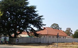
Fochville is a farming and mining town located in the Gauteng province of South Africa. It is part of the Merafong City Local Municipality, which also includes Kokosi, Carletonville and Khutsong. The area surrounding Fochville contains Sotho or Tswana ruins. Tlokwe Ruins are the remains of Sotho-Tswana settlements on the hills surrounding Fochville that were inhabited until the 1820s. Boer War hero Danie Theron was killed 5 km north of the town. The town itself was established as an agricultural centre in 1920 and was named after the World War I commander-in-chief of the Allied forces in France, Marshal of France Ferdinand Foch.
Sandweiler is a commune and town in southern Luxembourg. It is located 5 kilometres (3.1 mi) east of Luxembourg City.

Nasavrky is a town in Chrudim District in the Pardubice Region of the Czech Republic. It has about 1,700 inhabitants.
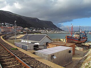
Kalk Bay is a fishing village and suburb of Cape Town. It lies on the east coast of False Bay. Much of the town is built on the slopes of mountains which border the sea, with peaks of Table Mountain Sandstone forming valleys. The railway from Cape Town to Simon's Town passes through Kalk Bay, which has one station near the harbour.

Itilleq is a settlement in the Qeqqata municipality in central-western Greenland. It is located on a small island around 1 km from the mainland, 45 km south of Sisimiut and 2 km north of the Arctic Circle on the shores of Davis Strait. It had 89 inhabitants in 2020.

Durbanville, previously called Pampoenkraal, is a town in the Western Cape province of South Africa, part of the greater Cape Town metropolitan area. It is a semi-rural residential suburb on the north-eastern outskirts of the metropolis surrounded by farms producing wine and wheat.

Bontebok National Park is a species-specific national park in South Africa. It was established in 1931 to ensure the preservation of the Bontebok. It is the smallest of South Africa's 19 National Parks, covering an area of 27.86 km2 The park is part of the Cape Floristic Region, which is a World Heritage Site.

Nový Knín is a town in Příbram District in the Central Bohemian Region of the Czech Republic. It has about 2,100 inhabitants. The historic town centre is well preserved and is protected by law as an urban monument zone.

Doksany is a municipality and village in Litoměřice District in the Ústí nad Labem Region of the Czech Republic. It has about 500 inhabitants. It is known for a Premonstratensian Doksany Convent.

Saint Helena Bay is a settlement in West Coast District Municipality in the Western Cape province of South Africa.

The Cape Town International Jazz Festival is an annual music festival held in Cape Town, South Africa. The first one was held in 2000 to 2005 and is recognized as the fourth largest jazz festival in the world and the largest jazz festival on the African continent. The festival was called the "Cape Town North Sea Jazz Festival" due to its association with the North Sea Jazz Festival in the Netherlands.

The Second Cabinet of Cyril Ramaphosa was the cabinet of the government of South Africa between 29 May 2019 and 19 June 2024. It was formed by President Ramaphosa after the 2019 general election and dissolved after the 2024 general election. In the interim it was reshuffled twice – once in August 2021 and once in March 2023 – and augmented in size from 28 ministers to 30 ministers.

Szűcsi is a village in Heves County, Hungary, beside of the Ágó creek, under the Mátra mountain ranges. As of 2022 census, it has a population of 1425. The village located 9.4 km from Hatvan–Fiľakovo railway line, 9.9 km from the main road 21 and 21.4 km from the M3 motorway. The closest train station with public transport in Zagyvaszántó.


