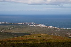
Mossel Bay is a harbour town of about 100,000 people on the Southern Cape of South Africa. It is an important tourism and farming region of the Western Cape Province. Mossel Bay lies 400 kilometres east of the country's seat of parliament, Cape Town, and 400 km west of Port Elizabeth, the largest city in the Eastern Cape. The older parts of the town occupy the north-facing side of the Cape St Blaize Peninsula, whilst the newer suburbs straddle the Peninsula and have spread eastwards along the sandy shore of the Bay.

Sterkfontein is a set of limestone caves of special interest in paleoanthropology located in Gauteng province, about 40 kilometres (25 mi) northwest of Johannesburg, South Africa in the Muldersdrift area close to the town of Krugersdorp. The archaeological sites of Swartkrans and Kromdraai are in the same area. Sterkfontein is a South African National Heritage Site and was also declared a World Heritage Site in 2000. The area in which it is situated is known as the Cradle of Humankind. The Sterkfontein Caves are also home to numerous wild African species including Belonogaster petiolata, a wasp species of which there is a large nesting presence.

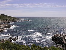
Gansbaai is a fishing town and popular tourist destination in the Overberg District Municipality, Western Cape, South Africa. It is known for its dense population of great white sharks and as a whale-watching location.
Blombos Cave is an archaeological site located in Blombos Private Nature Reserve, about 300 km east of Cape Town on the Southern Cape coastline, South Africa. The cave contains Middle Stone Age (MSA) deposits currently dated at between c. 100,000 and 70,000 years Before Present (BP), and a Late Stone Age sequence dated at between 2000 and 300 years BP. The cave site was first excavated in 1991 and field work has been conducted there on a regular basis since 1997, and is ongoing.
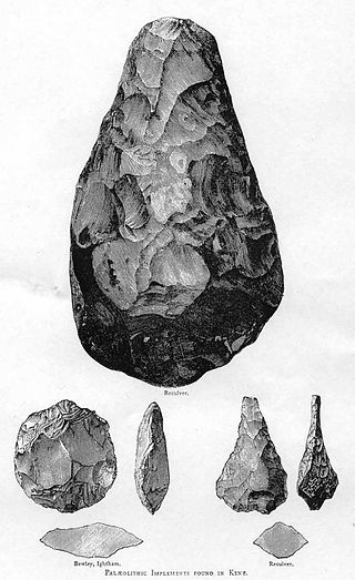
The Middle Stone Age was a period of African prehistory between the Early Stone Age and the Late Stone Age. It is generally considered to have begun around 280,000 years ago and ended around 50–25,000 years ago. The beginnings of particular MSA stone tools have their origins as far back as 550–500,000 years ago and as such some researchers consider this to be the beginnings of the MSA. The MSA is often mistakenly understood to be synonymous with the Middle Paleolithic of Europe, especially due to their roughly contemporaneous time span; however, the Middle Paleolithic of Europe represents an entirely different hominin population, Homo neanderthalensis, than the MSA of Africa, which did not have Neanderthal populations. Additionally, current archaeological research in Africa has yielded much evidence to suggest that modern human behavior and cognition was beginning to develop much earlier in Africa during the MSA than it was in Europe during the Middle Paleolithic. The MSA is associated with both anatomically modern humans as well as archaic Homo sapiens, sometimes referred to as Homo helmei. Early physical evidence comes from the Gademotta Formation in Ethiopia, the Kapthurin Formation in Kenya and Kathu Pan in South Africa.
The Klasies River Caves are a series of caves located east of the Klasies River Mouth on the Tsitsikamma coast in the Humansdorp district of Eastern Cape Province, South Africa. The Klasies River Main (KRM) site consists of 3 main caves and 2 shelters located within a cliff on the southern coast of the Eastern Cape. The site provides evidence for developments in stone tool technology, evolution of modern human anatomy and behavior, and changes in paleoecology and climate in Southern Africa based on evidence from plant remains.
The Prehistory of South Africa lasts from the Middle Stone Age until the 17th century. Southern Africa was first reached by Homo sapiens before 130,000 years ago, possibly before 260,000 years ago. The region remained in the Late Stone Age until the first traces of pastoralism were introduced about 2,000 years ago. The Bantu migration reached the area now South Africa around the first decade of the 3rd century, over 1800 years ago. Early Bantu kingdoms were established by the 11th century. First European contact dates to 1488, but European colonization began in the 17th century.
Makapansgat is an archaeological location within the Makapansgat and Zwartkrans Valleys, northeast of Mokopane in Limpopo province, South Africa. It is an important palaeontological site, with the local limeworks containing Australopithecus-bearing deposits dating to between 3.0 and 2.6 million years BP. The whole Makapan Valley has been declared a South African Heritage Site. Makapansgat belongs to the Cradle of Humankind.
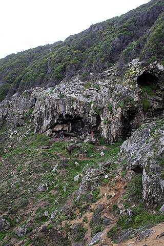
Pinnacle Point a small promontory immediately south of Mossel Bay, a town on the southern coast of South Africa. Excavations since the year 2000 of a series of caves at Pinnacle Point have revealed occupation by Middle Stone Age people between 170,000 and 40,000 years ago. The focus of excavations has been at Cave 13B (PP13B), where the earliest evidence for the systematic exploitation of marine resources (shellfish) and symbolic behaviour has been documented, and at Pinnacle Point Cave 5–6 (PP5–6), where the oldest evidence for the heat treatment of rock to make stone tools has been documented. The only human remains have been recovered from younger deposits at PP13B which are c. 100,000 years old.
Wonderwerk Cave is an archaeological site, formed originally as an ancient solution cavity in dolomite rocks of the Kuruman Hills, situated between Danielskuil and Kuruman in the Northern Cape Province, South Africa. It is a National Heritage Site, managed as a satellite of the McGregor Museum in Kimberley. Geologically, hillside erosion exposed the northern end of the cavity, which extends horizontally for about 140 m (460 ft) into the base of a hill. Accumulated deposits inside the cave, up to 7 m (23 ft) in-depth, reflect natural sedimentation processes such as water and wind deposition as well as the activities of animals, birds, and human ancestors over some 2 million years. The site has been studied and excavated by archaeologists since the 1940s and research here generates important insights into human history in the subcontinent of Southern Africa. Evidence within Wonderwerk cave has been called the oldest controlled fire. Wonderwerk means "miracle" in the Afrikaans language.
The oldest undisputed examples of figurative art are known from Europe and from Sulawesi, Indonesia, dated about 35,000 years old . Together with religion and other cultural universals of contemporary human societies, the emergence of figurative art is a necessary attribute of full behavioral modernity.
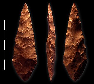
Howiesons Poort is a technological and cultural period characterized by material evidence with shared design features found in South Africa, Lesotho, and Namibia. It was named after the Howieson's Poort Shelter archaeological site near Grahamstown in South Africa, where the first assemblage of these tools was discovered. Howiesons Poort is believed, based on chronological comparisons between many sites, to have started around 64.8 thousand years ago and ended around 59.5 thousand years ago. It is considered to be a technocomplex, or a cultural period in archaeology classified by distinct and specific technological materials. Howiesons Poort is notable for its relatively complex tools, technological innovations, and cultural objects evidencing symbolic expression. One site in particular, Sibudu Cave, provides one of the key reference sequences for Howiesons Poort. Howiesons Poort assemblages are primarily found at sites south of the Limpopo River.
Howieson's Poort Shelter is a small rock shelter in South Africa containing the archaeological site from which the Howiesons Poort period in the Middle Stone Age gets its name. This period lasted around 5,000 years, between roughly 65,800 BP and 59,500 BP. This period is important as it, together with the Stillbay period 7,000 years earlier, provides the first evidence of human symbolism and technological skills that were later to appear in the Upper Paleolithic.

Border Cave is an archaeological site located in the western Lebombo Mountains in Kwazulu-Natal. The rock shelter has one of the longest archaeological records in southern Africa, which spans from the Middle Stone Age to the Iron Age.

Diepkloof Rock Shelter is a rock shelter in Western Cape, South Africa in which has been found some of the earliest evidence of the human use of symbols, in the form of patterns engraved upon ostrich eggshell water containers. These date around 60,000 years ago.
Byneskranskop is an archaeological site in present-day South Africa where the coastal plain meets the southern Cape Fold Belt. Neolithic human remains have been discovered in caves at the site. Carbon dating of the remains indicates the bodies date from 3,000 to 2,000 years BCE.
The Stilbaai Tidal Fish Traps are ancient National Heritage intertidal stonewall fish traps that occur in various spots on the Western Cape coast of South Africa from Gansbaai to Mosselbaai. Only a handful occur on the east coast. There are several concentrations of fish traps on the Hessequa coast between Gouritsmond, 30 km east of Stilbaai, and Witsand, 35 km to the southwest. The fish traps are located on the edge of the Skulpiesbaai Nature Reserve. In 2018, the Noordkapperpunt Stone-Walled Fish Traps were declared a National Heritage Site.
Elands Bay Cave is located near the mouth of the Verlorenvlei estuary on the Atlantic coast of South Africa's Western Cape Province. The climate has continuously become drier since the habitation of hunter-gatherers in the Later Pleistocene. The archaeological remains recovered from previous excavations at Elands Bay Cave have been studied to help answer questions regarding the relationship of people and their landscape, the role of climate change that could have determined or influenced subsistence changes, and the impact of pastoralism and agriculture on hunter-gatherer communities.
Boomplaas Cave is located in the Cango Valley in the foothills of the Swartberg mountain range, north of Oudtshoorn, Eden District Municipality in the Western Cape Province, South Africa. It has a 5 m (16 ft) deep stratified archaeological sequence of human presence, occupation and hunter-gatherer/herder acculturation that might date back as far as 80,000 years. The site's documentation contributed to the reconstruction of palaeo-environments in the context of changes in climate within periods of the Late Pleistocene and the Holocene. The cave has served multiple functions during its occupation, such as a kraal (enclosure) for animals, a place for the storage of oil rich fruits and as a hunting camp. Circular stone hearths and calcified dung remains of domesticated sheep as well as stone adzes and pottery art were excavated indicating that humans lived at the site and kept animals.

The history of Southern Africa has been divided into its prehistory, its ancient history, the major polities flourishing, the colonial period, and the post-colonial period, in which the current nations were formed. Southern Africa is bordered by Central Africa, East Africa, the Atlantic Ocean, the Indian Ocean, and the Sahara Desert. Colonial boundaries are reflected in the modern boundaries between contemporary Southern African states, cutting across ethnic and cultural lines, often dividing single ethnic groups between two or more states.