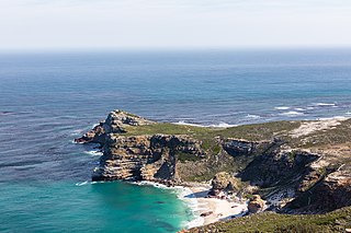
The Cape of Good Hope is a rocky headland on the Atlantic coast of the Cape Peninsula in South Africa.

Fitzroy Island National Park is a gazetted protected area covering Fitzroy Island, in Far North Queensland, Queensland, Australia. Fitzroy Island, is a continental island located 22 kilometres (14 mi) east of Cairns on the mainland.

Whale watching is the practice of observing whales and dolphins (cetaceans) in their natural habitat. Whale watching is mostly a recreational activity, but it can also serve scientific and/or educational purposes. A study prepared for International Fund for Animal Welfare in 2009 estimated that 13 million people went whale watching globally in 2008. Whale watching generates $2.1 billion per annum in tourism revenue worldwide, employing around 13,000 workers. The size and rapid growth of the industry has led to complex and continuing debates with the whaling industry about the best use of whales as a natural resource.

The southern right whale is a baleen whale, one of three species classified as right whales belonging to the genus Eubalaena. Southern right whales inhabit oceans south of the Equator, between the latitudes of 20° and 60° south. In 2009 the global population was estimated to be approximately 13,600.

The African penguin, also known as Cape penguin or South African penguin, is a species of penguin confined to southern African waters. It is the only penguin found in the Old World. Like all penguins, it is flightless, with a streamlined body and wings stiffened and flattened into flippers for a marine habitat. Adults weigh an average of 2.2–3.5 kg (4.9–7.7 lb) and are 60–70 cm (24–28 in) tall. The species has distinctive pink patches of skin above the eyes and a black facial mask. The body's upper parts are black and sharply delineated from the white underparts, which are spotted and marked with a black band.

The Spencer Gulf is the westernmost and larger of two large inlets on the southern coast of Australia, in the state of South Australia, facing the Great Australian Bight. It spans from the Cape Catastrophe and Eyre Peninsula in the west to Cape Spencer and Yorke Peninsula in the east.

Plettenberg Bay, nicknamed Plett, is the primary town of the Bitou Local Municipality in the Western Cape Province of South Africa. According to the census of 2001, the town had a population of 29,149. It was originally named Bahia Formosa by early Portuguese explorers and lies on South Africa's Garden Route 210 km from Port Elizabeth and about 600 km from Cape Town.

The kelp gull, also known as the Dominican gull, is a gull that breeds on coasts and islands through much of the Southern Hemisphere. The nominate L. d. dominicanus is the subspecies found around South America, parts of Australia, and New Zealand. L. d. vetula is a subspecies occurring around Southern Africa.

The Banc d'Arguin National Park of Bay of Arguin lies in Western Africa on the west coast of Mauritania between Nouakchott and Nouadhibou and is the former mouth of the Tamanrasset River. The World Heritage Site is a major site for migratory birds and breeding birds, including flamingos, pelicans and terns. Much of the breeding is on sand banks including the islands of Tidra, Niroumi, Nair, Kijji and Arguim. The surrounding waters are some of the richest fishing waters in western Africa and serve as nesting grounds for the entire western region.

Gansbaai is a fishing town and tourist destination in the Overberg District Municipality, Western Cape, South Africa. It is known for its dense population of great white sharks and as a whale-watching location.
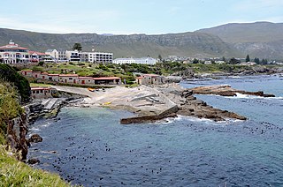
Hermanus, is a town on the southern coast of the Western Cape province of South Africa. It is known for Southern Right whale watching during the southern winter to spring seasons, and is a popular retirement location.

Bloubergstrand is a seaside suburb of the City of Cape Town, South Africa, along the shores of Table Bay, 15 kilometres (9.3 mi) due north of the city centre of Cape Town. The name Bloubergstrand literally means "blue mountain beach" in Afrikaans, and is derived from Blaauwberg, a nearby hill. Bloubergstrand is mainly a residential area, and attracts large numbers of visitors especially kitesurf enthusiasts.

Ras Nouadhibou is a 60-kilometre (37 mi) peninsula or headland divided by the border between Mauritania and Western Sahara on the African coast of the Atlantic Ocean. It is internationally known as Cabo Blanco in Spanish or Cap Blanc in French.

Algoa Bay is a maritime bay in the Eastern Cape, South Africa. It is located on the east coast, 683 kilometres (424 mi) east of the Cape of Good Hope.

The East Coast Trail (ECT) is a long-distance coastal footpath located in the Canadian province of Newfoundland and Labrador. It is a developed trail over 336 kilometres (209 mi) long, the creation of which began in 1994. It is made up of 25 linked wilderness paths and passes through more than 30 communities. It was named one of the best adventure destinations by National Geographic in 2012 and is extended and improved yearly.

The West Coast National Park lies 88 km (55 mi) north of Cape Town in the Western Cape province of South Africa. The park is found inside of the Cape West Coast Biosphere Reserve, part of the UNESCO Man and the Biosphere Programme. It is bordered by the Atlantic Ocean on the west and the R27 coastal road, and runs from the town of Yzerfontein in the south, up to the Langebaan Lagoon. The park is particularly well known for its bird life and for the spring flowers which occur in the months from August to September, especially in the Postberg flower reserve section of the park. The park, with the islands in Saldanha Bay, has been identified by BirdLife International as an Important Bird Area. The park was proclaimed in 1985, and is 36,259.8 hectares (140.000 sq mi) in size.

Langebaan is a town in the Western Cape province of South Africa on the eastern shore of Langebaan Lagoon.

Miller's Point is a headland and stretch of protected coastline in South Africa. It is located about 4 kilometres (2.5 mi) south of Simon's Town on the road to Cape Point.

Ichaboe Island is a small rocky island off Namibia's Diamond Coast. It is recognised by BirdLife International as an Important Bird Area (IBAs) for its seabird breeding colonies.
The Addo Elephant National Park Marine Protected Area is a marine conservation area in Algoa Bay, adjacent to the Nelson Mandela Bay Metropolitan Municipality, near Gqeberha, previously Port Elizabeth.


