
Overberg is a region in South Africa to the east of Cape Town beyond the Hottentots-Holland mountains. It lies along the Western Cape Province's south coast between the Cape Peninsula and the region known as the Garden Route in the east. The boundaries of the Overberg are the Hottentots-Holland mountains in the West; the Riviersonderend Mountains, part of the Cape Fold Belt, in the North; the Atlantic and Indian Oceans in the South and the Breede River in the East.

Swellendam Municipality is a local municipality located within the Overberg District Municipality, in the Western Cape province of South Africa. As of 2011, it had a population of 35,916. Its municipality code is WC034.

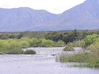
The Breede River, also known as Breë River, is a river in the Western Cape Province of South Africa. Travelling inland north from the city of Cape Town, the river runs in a west to east direction. The surrounding western mountains formed the first continental divide experienced by European settlers in the 18th century. The Titus River and Dwars River become the Breë River.

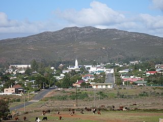
Swellendam is the fourth oldest town in South Africa, a town with 17,537 inhabitants situated in the Western Cape province. The town has over 50 provincial heritage sites, most of them buildings of Cape Dutch architecture. Swellendam is situated on the N2, approximately 220 km from both Cape Town and George.

The Overberg District Municipality is a district municipality that governs the Overberg region in the Western Cape province of South Africa. It is divided into four local municipalities and includes the major towns of Grabouw, Caledon, Hermanus, Bredasdorp and Swellendam. The municipal area covers 12,241 square kilometres (4,726 sq mi) and had in 2007 an estimated population of 212,787 people in 60,056 households.

The Langeberg Range is a mountain range in the Western Cape province of South Africa. Its highest peak is Keeromsberg at 2,075 m that lies 15 km northeast of the town of Worcester. Some of the highest peaks of the range are located just to the north of Swellendam, in a subrange known as the Clock Peaks whose highest point is the 1,710 m high Misty Point. Local lore states one can tell the time by means of the shadows cast by the seven summits of the Clock Peaks.

Heidelberg is a town in the Western Cape, South Africa. It is located near South Africa's south coast, on the N2 highway, within the Hessequa region, 274 km east of Cape Town. Heidelberg marks the start of the Garden Route. Heidelberg is part of the Hessequa Local Municipality.

Aberdeen is a small town in the Sarah Baartman District Municipality of the Eastern Cape province of South Africa. With its numerous examples of Victorian architecture, it is one of the architectural conservation areas of the Karoo.
Marloth Nature Reserve is a nature reserve in Swellendam Local Municipality, Western Cape, South Africa. It conserves the central Langeberg mountains, between the towns of Swellendam, Ashton, Barrydale and Suurbraak. The reserve includes the Clock Peaks, two prominent landmarks near Swellendam.
Bredasdorp is a town in the Southern Overberg region of the Western Cape, South Africa, and the main economic and service hub of that region. It lies on the northern edge of the Agulhas Plain, about 160 kilometres (100 mi) south-east of Cape Town and 35 kilometres (22 mi) north of Cape Agulhas, the southernmost tip of Africa.

Riversdale is a town located along the N2 highway, within the Hessequa region between Cape Town and George on the Agulhas Coastal Plain of the southern Western Cape province of South Africa. It is an agricultural service oriented town, being a hub for shopping and other services for surrounding farming communities, smaller towns, and coastal resorts, like Witsand and Stilbaai. It is located beneath the imposing Langeberg Mountains to the north, with Sleeping Beauty Mountain Peak overlooking the town. The town is home to the second largest collection of Thomas Bowler paintings within South Africa and is also the only town in the country, in which you would find a Ukrainian Museum of Culture. Riversdale links with the Klein Karoo, via the tarred Garcia's Mountain Pass, which offers traditional Karoo landscapes and wide open spaces for motorcyclists.

Infanta is a settlement in Overberg District Municipality in the Western Cape province of South Africa.
The Breede River Canoe Marathon is an annual South African K2 (doubles) race down the Breede River from Robertson to Swellendam in the Western Cape over a distance of 75 km. The two-day race through scenic wine country, was first run in 1968, and is usually held during September when good rains ensure reasonable water levels.

Port Beaufort is a settlement in Garden Route District Municipality in the Western Cape province of South Africa.

Kogelberg Nature Reserve is a nature reserve of 3,000 ha comprising the Kogelberg Mountain Range, to the east of Cape Town, South Africa.
Protem is a hamlet some 30 km north of Bredasdorp and 40 km south-west of Swellendam. The name is an abbreviation of Latin pro tempore, 'for the time being'. The centre was to have served as a temporary railway terminal on the line from Caledon to Swellendam, but the rest of the line was never constructed.

Swellendam Commando was a light infantry regiment of the South African Army. It formed part of the South African Army Infantry Formation as well as the South African Territorial Reserve.
Nicholas Georg Myburgh is a South African farmer, lawyer and politician for the Democratic Alliance. He has been a Member of Parliament (MP) since 2021. Myburgh had previously served as the Executive Mayor of the Swellendam Local Municipality from 2011 to 2021.
The Swellendam Local Municipality council consists of eleven members elected by mixed-member proportional representation. Six councillors are elected by first-past-the-post voting in six wards, while the remaining five are chosen from party lists so that the total number of party representatives is proportional to the number of votes received. In the election of 1 November 2021, the Democratic Alliance (DA) retained its majority of six seats on the council.

The Excelsior Wind Energy Facility is a wind farm in the Swellendam Local Municipality, built 30km southwest of the town of Swellendam, in the Western Cape province of South Africa.


