
Orkney is a gold mining town situated in the Klerksdorp district of the North West province, South Africa. It lies on the banks of the Vaal River approximately 180 km from Johannesburg near the N12.
Pongola is a town on the north bank of the uPhongolo River, in a fertile valley on the N2, near the Lubombo Mountains, in the valleys of Zululand, easily accessible to the Swaziland border posts. It was part of the Transvaal panhandle between the Phongolo (Natal) and Swaziland until 1994, when it was transferred to KwaZulu-Natal.
Langeberg Municipality, known before 28 August 2009 as Breede River/Winelands Municipality, is a local municipality located within the Cape Winelands District Municipality, in the Western Cape province of South Africa. As of 2011, it had a population of 97,724. Its municipality code is WC026.
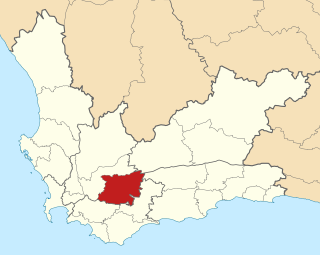
Hessequa Municipality, known before 24 June 2005 as Langeberg Municipality, is a local municipality within the Garden Route District Municipality, in the Western Cape province of South Africa. It is flanked by the lower Breede River to the west and the Gourits River to the east. As of 2011, the population was 52,642. Its municipality code is WC042. The name Hessequa, meaning "people of the trees", refers to the indigenous Khoikhoi people.

Swellendam Municipality is a local municipality located within the Overberg District Municipality, in the Western Cape province of South Africa. As of 2011, it had a population of 35,916. Its municipality code is WC034.

The Breede River, also known as Breë River, is a river in the Western Cape Province of South Africa. Travelling inland north from the city of Cape Town, the river runs in a west to east direction. The surrounding western mountains formed the first continental divide experienced by European settlers in the 18th century. The Titus River and Dwars River become the Breë River.

Swellendam is the fourth oldest town in South Africa, a town with 17,537 inhabitants situated in the Western Cape province. The town has over 50 provincial heritage sites, most of them buildings of Cape Dutch architecture. Swellendam is situated on the N2, approximately 220 km from both Cape Town and George.

The N2 is a national route in South Africa that runs from Cape Town through George, Gqeberha, East London, Mthatha, Port Shepstone and Durban to Ermelo. It is the main highway along the Indian Ocean coast of the country. Its current length of 2,255 kilometres (1,401 mi) makes it the longest numbered route in South Africa.

Heidelberg is a town in the Western Cape, South Africa. It is located near South Africa's south coast, on the N2 highway, within the Hessequa region, 274 km east of Cape Town. Heidelberg marks the start of the Garden Route. Heidelberg is part of the Hessequa Local Municipality.

Durbanville, previously called Pampoenkraal, is a town in the Western Cape province of South Africa, part of the greater Cape Town metropolitan area. Durbanville is a semi-rural residential suburb on the north-eastern outskirts of the metropolis surrounded by farms producing wine and wheat.

Helderberg refers to a planning district of the City of Cape Town metropolitan municipality, the mountain after which it is named, a wine-producing area in the Western Cape province of South Africa, or a small census area in Somerset West.

Bontebok National Park is a species-specific national park in South Africa. It was established in 1931 to ensure the preservation of the Bontebok. It is the smallest of South Africa's 19 National Parks, covering an area of 27.86 km2 The park is part of the Cape Floristic Region, which is a World Heritage Site.

The Hottentots Holland Mountains are part of the Cape Fold Belt in the Western Cape, South Africa. The mountain range forms a barrier between the Cape Town metropolitan area and the southern Overberg coast.

Riversdale is a town located along the N2 highway, within the Hessequa region between Cape Town and George on the Agulhas Coastal Plain of the southern Western Cape province of South Africa. It is an agricultural service oriented town, being a hub for shopping and other services for surrounding farming communities, smaller towns, and coastal resorts, like Witsand and Stilbaai. It is located beneath the imposing Langeberg Mountains to the north, with Sleeping Beauty Mountain Peak overlooking the town. The town is home to the second largest collection of Thomas Bowler paintings within South Africa and is also the only town in the country, in which you would find a Ukrainian Museum of Culture. Riversdale links with the Klein Karoo, via the tarred Garcia's Mountain Pass, which offers traditional Karoo landscapes and wide open spaces for motorcyclists.

Kogelberg Nature Reserve is a nature reserve of 3,000 ha comprising the Kogelberg Mountain Range, to the east of Cape Town, South Africa.
The Gouritz Cluster Biosphere Reserve is located in the Western Cape of South Africa. It is the 7th and largest of South Africa’s biosphere reserves; divided into four connected sectors ranging from sea level to 2,240 metres. The area is the only place in the world where three recognised biodiversity hotspots converge. The site is characterised by high endemism of plant species and threatened invertebrates including seven endemic species of the enigmatic beetle genus Colophon and 14 butterfly species. It provides a migratory route for large mammals such as the leopard and serves as a nursery for marine species.

Situated halfway between Cape Town, South Africa and George, you will find Olivedale. It is a small farming community located at the foot of the Langeberg Mountains and marks the spot where the Buffeljagsriver and the Breede River meet. The entrance to Olivedale has a display of farm implements from the days of yore, with cattle roaming free and fruit orchards turning the area into different shades of pink and purple from September.

Grootvadersbosch is a historic farm in the Overberg, and the surrounding area is currently a nature reserve in the southern portion of the Boosmansbos Wilderness Area, in Western Cape, South Africa.
The Dutch Reformed Church in Barrydale is a congregation of the Dutch Reformed Church centered on the village of Barrydale in the picturesque surroundings of the Langeberg on the R62, 62.5 km (38.8 mi) south-east of Montagu, 76 km (47 mi) south-west of Ladismith and more or less equidistant through the Tradouw Pass from Swellendam and Heidelberg. In 2014, the congregation had 49 baptized and 211 professing members. In that year the pastor was Rev. W. J. van Zyl.

