Coordinate system

Last updated
The spherical coordinate system is commonly used in physics. It assigns three numbers (known as coordinates) to every point in Euclidean space: radial distance r, polar angle th (theta), and azimuthal angle ph (phi). The symbol r (rho) is often used instead of r. 3D Spherical.svg
The spherical coordinate system is commonly used in physics. It assigns three numbers (known as coordinates) to every point in Euclidean space: radial distance r, polar angle θ (theta), and azimuthal angle φ (phi). The symbol ρ (rho) is often used instead of r.

In geometry, a coordinate system is a system that uses one or more numbers, or coordinates, to uniquely determine the position of the points or other geometric elements on a manifold such as Euclidean space. [1] [2] The order of the coordinates is significant, and they are sometimes identified by their position in an ordered tuple and sometimes by a letter, as in "the x-coordinate". The coordinates are taken to be real numbers in elementary mathematics, but may be complex numbers or elements of a more abstract system such as a commutative ring. The use of a coordinate system allows problems in geometry to be translated into problems about numbers and vice versa; this is the basis of analytic geometry. [3]

Contents

Common coordinate systems

Number line

The simplest example of a coordinate system is the identification of points on a line with real numbers using the number line . In this system, an arbitrary point O (the origin) is chosen on a given line. The coordinate of a point P is defined as the signed distance from O to P, where the signed distance is the distance taken as positive or negative depending on which side of the line P lies. Each point is given a unique coordinate and each real number is the coordinate of a unique point. [4]

The number line Number-line.svg
The number line

Cartesian coordinate system

Cartesian-coordinate-system.svg
Rectangular coordinates.svg
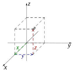
The Cartesian coordinate system in three-dimensional space

The prototypical example of a coordinate system is the Cartesian coordinate system. In the plane, two perpendicular lines are chosen and the coordinates of a point are taken to be the signed distances to the lines. [5] In three dimensions, three mutually orthogonal planes are chosen and the three coordinates of a point are the signed distances to each of the planes. [6] This can be generalized to create n coordinates for any point in n-dimensional Euclidean space.

Depending on the direction and order of the coordinate axes, the three-dimensional system may be a right-handed or a left-handed system.

Polar coordinate system

Another common coordinate system for the plane is the polar coordinate system. [7] A point is chosen as the pole and a ray from this point is taken as the polar axis. For a given angle θ, there is a single line through the pole whose angle with the polar axis is θ (measured counterclockwise from the axis to the line). Then there is a unique point on this line whose signed distance from the origin is r for given number r. For a given pair of coordinates (r, θ) there is a single point, but any point is represented by many pairs of coordinates. For example, (r, θ), (r, θ+2π) and (−r, θ+π) are all polar coordinates for the same point. The pole is represented by (0, θ) for any value of θ.

Cylindrical and spherical coordinate systems

Cylindrical coordinate system Cylindrical Coordinates.svg
Cylindrical coordinate system

There are two common methods for extending the polar coordinate system to three dimensions. In the cylindrical coordinate system, a z-coordinate with the same meaning as in Cartesian coordinates is added to the r and θ polar coordinates giving a triple (r, θ, z). [8] Spherical coordinates take this a step further by converting the pair of cylindrical coordinates (r, z) to polar coordinates (ρ, φ) giving a triple (ρ, θ, φ). [9]

Homogeneous coordinate system

A point in the plane may be represented in homogeneous coordinates by a triple (x, y, z) where x/z and y/z are the Cartesian coordinates of the point. [10] This introduces an "extra" coordinate since only two are needed to specify a point on the plane, but this system is useful in that it represents any point on the projective plane without the use of infinity. In general, a homogeneous coordinate system is one where only the ratios of the coordinates are significant and not the actual values.

Other commonly used systems

Some other common coordinate systems are the following:

There are ways of describing curves without coordinates, using intrinsic equations that use invariant quantities such as curvature and arc length. These include:

Coordinates of geometric objects

Coordinates systems are often used to specify the position of a point, but they may also be used to specify the position of more complex figures such as lines, planes, circles or spheres. For example, Plücker coordinates are used to determine the position of a line in space. [11] When there is a need, the type of figure being described is used to distinguish the type of coordinate system, for example the term line coordinates is used for any coordinate system that specifies the position of a line.

It may occur that systems of coordinates for two different sets of geometric figures are equivalent in terms of their analysis. An example of this is the systems of homogeneous coordinates for points and lines in the projective plane. The two systems in a case like this are said to be dualistic. Dualistic systems have the property that results from one system can be carried over to the other since these results are only different interpretations of the same analytical result; this is known as the principle of duality . [12]

Transformations

There are often many different possible coordinate systems for describing geometrical figures. The relationship between different systems is described by coordinate transformations, which give formulas for the coordinates in one system in terms of the coordinates in another system. For example, in the plane, if Cartesian coordinates (x, y) and polar coordinates (r, θ) have the same origin, and the polar axis is the positive x axis, then the coordinate transformation from polar to Cartesian coordinates is given by x = r cosθ and y = r sinθ.

With every bijection from the space to itself two coordinate transformations can be associated:

For example, in 1D, if the mapping is a translation of 3 to the right, the first moves the origin from 0 to 3, so that the coordinate of each point becomes 3 less, while the second moves the origin from 0 to −3, so that the coordinate of each point becomes 3 more.

Coordinate lines/curves and planes/surfaces

Given a coordinate system, if one of the coordinates of a point varies while the other coordinates are held constant, then the resulting curve is called a coordinate curve. If a coordinate curve is a straight line, it is called a coordinate line. A coordinate system for which some coordinate curves are not lines is called a curvilinear coordinate system. [13]

A coordinate line with all constant coordinates equal to zero is called a coordinate axis.

In a Cartesian coordinate system, all coordinates curves are lines, and, therefore, there are as many coordinate axes as coordinates. Moreover, the coordinate axes are pairwise orthogonal.

A polar coordinate system is a curvilinear system where coordinate curves are lines or circles. However, one of the coordinate curves is reduced to a single point, the origin, which is often viewed as a circle of radius zero. Similarly, spherical and cylindrical coordinate systems have coordinate curves that are lines, circles or circles of radius zero.

Many curves can occur as coordinate curves. For example, the coordinate curves of parabolic coordinates are parabolas.

Coordinate surfaces of the three-dimensional paraboloidal coordinates. Parabolic coordinates 3D.png
Coordinate surfaces of the three-dimensional paraboloidal coordinates.

In three-dimensional space, if one coordinate is held constant and the other two are allowed to vary, then the resulting surface is called a coordinate surface. For example, the coordinate surfaces obtained by holding ρ constant in the spherical coordinate system are the spheres with center at the origin. In three-dimensional space the intersection of two coordinate surfaces is a coordinate curve. In the Cartesian coordinate system we may speak of coordinate planes.

Similarly, coordinate hypersurfaces are the (n − 1)-dimensional spaces resulting from fixing a single coordinate of an n-dimensional coordinate system. [14]

Coordinate maps

The concept of a coordinate map, or coordinate chart is central to the theory of manifolds. A coordinate map is essentially a coordinate system for a subset of a given space with the property that each point has exactly one set of coordinates. More precisely, a coordinate map is a homeomorphism from an open subset of a space X to an open subset of Rn. [15] It is often not possible to provide one consistent coordinate system for an entire space. In this case, a collection of coordinate maps are put together to form an atlas covering the space. A space equipped with such an atlas is called a manifold and additional structure can be defined on a manifold if the structure is consistent where the coordinate maps overlap. For example, a differentiable manifold is a manifold where the change of coordinates from one coordinate map to another is always a differentiable function.

Orientation-based coordinates

In geometry and kinematics, coordinate systems are used to describe the (linear) position of points and the angular position of axes, planes, and rigid bodies. [16] In the latter case, the orientation of a second (typically referred to as "local") coordinate system, fixed to the node, is defined based on the first (typically referred to as "global" or "world" coordinate system). For instance, the orientation of a rigid body can be represented by an orientation matrix, which includes, in its three columns, the Cartesian coordinates of three points. These points are used to define the orientation of the axes of the local system; they are the tips of three unit vectors aligned with those axes.

Geographic systems

The Earth as a whole is one of the most common geometric spaces requiring the precise measurement of location, and thus coordinate systems. Starting with the Greeks of the Hellenistic period, a variety of coordinate systems have been developed based on the types above, including:

See also

Relativistic coordinate systems

Related Research Articles

In mathematics, analytic geometry, also known as coordinate geometry or Cartesian geometry, is the study of geometry using a coordinate system. This contrasts with synthetic geometry.

<span class="mw-page-title-main">Cartesian coordinate system</span> Most common coordinate system (geometry)

In geometry, a Cartesian coordinate system in a plane is a coordinate system that specifies each point uniquely by a pair of real numbers called coordinates, which are the signed distances to the point from two fixed perpendicular oriented lines, called coordinate lines, coordinate axes or just axes of the system. The point where they meet is called the origin and has (0, 0) as coordinates.

In mathematics, an equation is a mathematical formula that expresses the equality of two expressions, by connecting them with the equals sign =. The word equation and its cognates in other languages may have subtly different meanings; for example, in French an équation is defined as containing one or more variables, while in English, any well-formed formula consisting of two expressions related with an equals sign is an equation.

<span class="mw-page-title-main">Euclidean space</span> Fundamental space of geometry

Euclidean space is the fundamental space of geometry, intended to represent physical space. Originally, in Euclid's Elements, it was the three-dimensional space of Euclidean geometry, but in modern mathematics there are Euclidean spaces of any positive integer dimension n, which are called Euclidean n-spaces when one wants to specify their dimension. For n equal to one or two, they are commonly called respectively Euclidean lines and Euclidean planes. The qualifier "Euclidean" is used to distinguish Euclidean spaces from other spaces that were later considered in physics and modern mathematics.

<span class="mw-page-title-main">Polar coordinate system</span> Coordinates determined by distance and angle

In mathematics, the polar coordinate system is a two-dimensional coordinate system in which each point on a plane is determined by a distance from a reference point and an angle from a reference direction. The reference point is called the pole, and the ray from the pole in the reference direction is the polar axis. The distance from the pole is called the radial coordinate, radial distance or simply radius, and the angle is called the angular coordinate, polar angle, or azimuth. Angles in polar notation are generally expressed in either degrees or radians.

<span class="mw-page-title-main">Spherical coordinate system</span> 3-dimensional coordinate system

In mathematics, a spherical coordinate system is a coordinate system for three-dimensional space where the position of a given point in space is specified by three numbers, : the radial distance of the radial liner connecting the point to the fixed point of origin ; the polar angle θ of the radial line r; and the azimuthal angle φ of the radial line r.

<i>n</i>-sphere Generalized sphere of dimension n (mathematics)

In mathematics, an n-sphere or hypersphere is an n-dimensional generalization of the 1-dimensional circle and 2-dimensional sphere to any non-negative integer n. The n-sphere is the setting for n-dimensional spherical geometry.

<span class="mw-page-title-main">Stereographic projection</span> Particular mapping that projects a sphere onto a plane

In mathematics, a stereographic projection is a perspective projection of the sphere, through a specific point on the sphere, onto a plane perpendicular to the diameter through the point. It is a smooth, bijective function from the entire sphere except the center of projection to the entire plane. It maps circles on the sphere to circles or lines on the plane, and is conformal, meaning that it preserves angles at which curves meet and thus locally approximately preserves shapes. It is neither isometric nor equiareal.

<span class="mw-page-title-main">Complex plane</span> Geometric representation of the complex numbers

In mathematics, the complex plane is the plane formed by the complex numbers, with a Cartesian coordinate system such that the x-axis, called the real axis, is formed by the real numbers, and the y-axis, called the imaginary axis, is formed by the imaginary numbers.

<span class="mw-page-title-main">Hyperbolic geometry</span> Non-Euclidean geometry

In mathematics, hyperbolic geometry is a non-Euclidean geometry. The parallel postulate of Euclidean geometry is replaced with:

<span class="mw-page-title-main">Homogeneous coordinates</span> Coordinate system used in projective geometry

In mathematics, homogeneous coordinates or projective coordinates, introduced by August Ferdinand Möbius in his 1827 work Der barycentrische Calcul, are a system of coordinates used in projective geometry, just as Cartesian coordinates are used in Euclidean geometry. They have the advantage that the coordinates of points, including points at infinity, can be represented using finite coordinates. Formulas involving homogeneous coordinates are often simpler and more symmetric than their Cartesian counterparts. Homogeneous coordinates have a range of applications, including computer graphics and 3D computer vision, where they allow affine transformations and, in general, projective transformations to be easily represented by a matrix. They are also used in fundamental elliptic curve cryptography algorithms.

<span class="mw-page-title-main">Rotation (mathematics)</span> Motion of a certain space that preserves at least one point

Rotation in mathematics is a concept originating in geometry. Any rotation is a motion of a certain space that preserves at least one point. It can describe, for example, the motion of a rigid body around a fixed point. Rotation can have a sign (as in the sign of an angle): a clockwise rotation is a negative magnitude so a counterclockwise turn has a positive magnitude. A rotation is different from other types of motions: translations, which have no fixed points, and (hyperplane) reflections, each of them having an entire (n − 1)-dimensional flat of fixed points in a n-dimensional space.

In Euclidean geometry, two-dimensional rotations and reflections are two kinds of Euclidean plane isometries which are related to one another.

<span class="mw-page-title-main">Line (geometry)</span> Straight figure with zero width and depth

In geometry, a straight line, usually abbreviated line, is an infinitely long object with no width, depth, or curvature, an idealization of such physical objects as a straightedge, a taut string, or a ray of light. Lines are spaces of dimension one, which may be embedded in spaces of dimension two, three, or higher. The word line may also refer, in everyday life, to a line segment, which is a part of a line delimited by two points.

<span class="mw-page-title-main">Radius</span> Segment in a circle or sphere from its center to its perimeter or surface and its length

In classical geometry, a radius of a circle or sphere is any of the line segments from its center to its perimeter, and in more modern usage, it is also their length. The name comes from the Latin radius, meaning ray but also the spoke of a chariot wheel. The typical abbreviation and mathematical variable name for radius is R or r. By extension, the diameter D is defined as twice the radius:

<span class="mw-page-title-main">Three-dimensional space</span> Geometric model of the physical space

In geometry, a three-dimensional space is a mathematical space in which three values (coordinates) are required to determine the position of a point. Most commonly, it is the three-dimensional Euclidean space, that is, the Euclidean space of dimension three, which models physical space. More general three-dimensional spaces are called 3-manifolds. The term may also refer colloquially to a subset of space, a three-dimensional region, a solid figure.

<span class="mw-page-title-main">Rotation of axes in two dimensions</span> Transformation of coordinates through an angle

In mathematics, a rotation of axes in two dimensions is a mapping from an xy-Cartesian coordinate system to an x′y′-Cartesian coordinate system in which the origin is kept fixed and the x′ and y′ axes are obtained by rotating the x and y axes counterclockwise through an angle . A point P has coordinates (x, y) with respect to the original system and coordinates (x′, y′) with respect to the new system. In the new coordinate system, the point P will appear to have been rotated in the opposite direction, that is, clockwise through the angle . A rotation of axes in more than two dimensions is defined similarly. A rotation of axes is a linear map and a rigid transformation.

<span class="mw-page-title-main">Euclidean plane</span> Geometric model of the planar projection of the physical universe

In mathematics, a Euclidean plane is a Euclidean space of dimension two, denoted E2. It is a geometric space in which two real numbers are required to determine the position of each point. It is an affine space, which includes in particular the concept of parallel lines. It has also metrical properties induced by a distance, which allows to define circles, and angle measurement.

In geometry, line coordinates are used to specify the position of a line just as point coordinates are used to specify the position of a point.

In the hyperbolic plane, as in the Euclidean plane, each point can be uniquely identified by two real numbers. Several qualitatively different ways of coordinatizing the plane in hyperbolic geometry are used.

References

Citations

  1. Woods p. 1
  2. Weisstein, Eric W. "Coordinate System". MathWorld .
  3. Weisstein, Eric W. "Coordinates". MathWorld .
  4. Stewart, James B.; Redlin, Lothar; Watson, Saleem (2008). College Algebra (5th ed.). Brooks Cole. pp. 13–19. ISBN   978-0-495-56521-5.
  5. Anton, Howard; Bivens, Irl C.; Davis, Stephen (2021). Calculus: Multivariable. John Wiley & Sons. p. 657. ISBN   978-1-119-77798-4.
  6. Moon P, Spencer DE (1988). "Rectangular Coordinates (x, y, z)". Field Theory Handbook, Including Coordinate Systems, Differential Equations, and Their Solutions (corrected 2nd, 3rd print ed.). New York: Springer-Verlag. pp. 9–11 (Table 1.01). ISBN   978-0-387-18430-2.
  7. Finney, Ross; George Thomas; Franklin Demana; Bert Waits (June 1994). Calculus: Graphical, Numerical, Algebraic (Single Variable Version ed.). Addison-Wesley Publishing Co. ISBN   0-201-55478-X.
  8. Margenau, Henry; Murphy, George M. (1956). The Mathematics of Physics and Chemistry . New York City: D. van Nostrand. p.  178. ISBN   978-0-88275-423-9. LCCN   55010911. OCLC   3017486.
  9. Morse, PM; Feshbach, H (1953). Methods of Theoretical Physics, Part I. New York: McGraw-Hill. p. 658. ISBN   0-07-043316-X. LCCN   52011515.
  10. Jones, Alfred Clement (1912). An Introduction to Algebraical Geometry. Clarendon.
  11. Hodge, W.V.D.; D. Pedoe (1994) [1947]. Methods of Algebraic Geometry, Volume I (Book II). Cambridge University Press. ISBN   978-0-521-46900-5.
  12. Woods p. 2
  13. Tang, K. T. (2006). Mathematical Methods for Engineers and Scientists. Vol. 2. Springer. p. 13. ISBN   3-540-30268-9.
  14. Liseikin, Vladimir D. (2007). A Computational Differential Geometry Approach to Grid Generation. Springer. p. 38. ISBN   978-3-540-34235-9.
  15. Munkres, James R. (2000) Topology. Prentice Hall. ISBN   0-13-181629-2.
  16. Hanspeter Schaub; John L. Junkins (2003). "Rigid body kinematics". Analytical Mechanics of Space Systems. American Institute of Aeronautics and Astronautics. p. 71. ISBN   1-56347-563-4.

Sources