
The Periplus of the Erythraean Sea, also known by its Latin name as the Periplus Maris Erythraei, is a Greco-Roman periplus written in Koine Greek that describes navigation and trading opportunities from Roman Egyptian ports like Berenice Troglodytica along the coast of the Red Sea, and others along Horn of Africa, the Persian Gulf, Arabian Sea and the Indian Ocean, including the modern-day Sindh region of Pakistan and southwestern regions of India. The text has been ascribed to different dates between the first and third centuries, but a mid-first-century date is now the most commonly accepted. While the author is unknown, it is clearly a first-hand description by someone familiar with the area and is nearly unique in providing accurate insights into what the ancient Hellenic world knew about the lands around the Indian Ocean.

Mafia Island is an island and district of Pwani Region, Tanzania. The island is the third largest in Tanzanian ocean territory, but is not administratively included within the semi-autonomous region of Zanzibar, which has been politically separate since 1890. Mafia Island forms the major part of Mafia District, one of the six administrative districts in the Pwani coastal region. The local archipelago and the main island are sometimes called Chole shamba in Swahili, hinterlands of the former maintown of Chole on Mafia Bay.
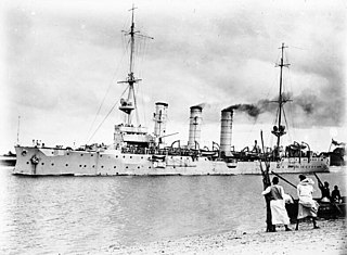
SMS Königsberg was the lead ship of her class of light cruisers built by the German Kaiserliche Marine. Named after Königsberg, the capital of East Prussia, she was laid down in January 1905, launched in December of that year and completed by June 1906. Her class included three other ships: Stettin, Stuttgart, and Nürnberg. Königsberg was armed with a main battery of ten 10.5-centimeter (4.1 in) guns and had a top speed of 24.1 knots.

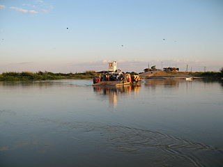
The Rufiji River lies entirely within Tanzania. It is also the largest and longest river in the country. The river is formed by the confluence of the Kilombero and Luwegu rivers. It is approximately 600 kilometres (370 mi) long, with its source in southwestern Tanzania and its mouth on the Indian Ocean opposite Mafia Island across the Mafia Channel, in Pwani Region. Its principal tributary is the Great Ruaha River. It is navigable for approximately 100 kilometres (62 mi).

Rufiji is one of the six districts of the Pwani Region of Tanzania. It is bordered to the north by the Kisarawe and Mkuranga Districts, to the east by the Indian Ocean, to the south by the Kilwa District, Lindi Region and to the west by the Morogoro Region.
Rhapta was an emporion said to be on the coast of Southeast Africa, first described in the 1st century CE. Its location has not been firmly identified, although there are a number of plausible candidate sites. The ancient Periplus of the Erythraean Sea described Rhapta as "the last emporion of Azania", two days' travel south of the Menouthias islands. The Periplus also states that the city and port were ruled by South Arabian vassals of the Himyarite kingdom, particularly a certain “ Mapharitic chieftain.”

Pwani Region is one of Tanzania's 31 administrative regions. The word "Pwani" in Swahili means the "coast". The regional capital is the town of Kibaha. The Region borders the Tanga Region to the north, Morogoro Region to the west, Lindi Region to the south, and surrounds Dar es Salaam Region to the east. The Indian Ocean also borders the region to its northeast and southeast. The region is home to Mafia Island, the Rufiji delta and Saadani National Park. The region is home to Bagamoyo town, a historical Swahili settlement, and the first colonial capital of German East Africa. According to the 2012 national census, the region had a population of 1,098,668, which was slightly lower than the pre-census projection of 1,110,917. From 2002 to 2012, the region's 2.2 percent average annual population growth rate was the seventeenth-highest in the country. It was also the 21st most densely populated region with 34 people per square kilometre., the region is slightly larger than Belgium.

The Battle of the Rufiji Delta was fought in German East Africa from October 1914–July 1915 during the First World War, between the German Navy's light cruiser SMS Königsberg, and a powerful group of British warships. The battle was a series of attempts, ultimately successful, to sink the blockaded German light cruiser.

The Selous Game Reserve is a protected area in southern Tanzania. It covers a total area of 50,000 km2 (19,000 sq mi) and has additional buffer zones. It was designated a UNESCO World Heritage Site in 1982 due to its wildlife diversity and undisturbed nature. Some of the diverse wildlife of the savannah include the presence of the African bush elephant, black rhino, hippopotamus, African Lion, East African wild dog, Cape buffaloes, Masai giraffe, Plains zebra, and Nile crocodile. Permanent human habitation is not permitted within the reserve. All human entry and exit is controlled by the Wildlife Division of the Tanzanian Ministry of Natural Resources and Tourism.

Kamenny Islands are a group of three islands in the Neva delta, in Saint Petersburg, Russia.
The Rufiji are an ethnic and linguistic group based in the central coast of Tanzania specifically Rufiji District next to the Rufiji River delta in Pwani Region. In 1987 the Rufiji population was estimated to number 200,000.
The Matumbi are a Bantu ethnolinguistic group native to Kilwa District, Lindi Region in southern Tanzania, who speak the Matumbi language. They are also the native inhabitants of the Songosongo island archipelago. Their homeland is also south of the Rufiji delta in southern Pwani Region in Rufiji District. In 1978 the Matumbi population was estimated to number 72,000. They are the largest ethnic group in Kilwa District. The Matumbi Highlands are named after them.

The Kirov Islands or Sergey Kirov Islands is an island group in the Kara Sea, Russian Federation. It is an archipelago of small islands covered with tundra vegetation located about 140 km (87 mi) from the coast of Siberia and 100 km (62 mi) northwest of the Nordenskiöld Archipelago.

The Humber-class monitors were three large gunboats under construction for the Brazilian Navy in Britain in 1913. Designed for service on the Amazon River, the ships were of shallow draft and heavy armament and were ideally suited to inshore, riverine and coastal work but unsuitable for service at sea, where their weight and light draft reduced their speed from a projected twelve knots to under four. The class comprised Humber, Mersey and Severn. All three were taken over by the Royal Navy shortly before the outbreak of the First World War and were commissioned as small monitors. All three saw extensive service during the war and were sold in 1919.

The Battle of Zanzibar was an encounter between the German Kaiserliche Marine and the British Royal Navy early in the First World War. While taking on coal in the delta of the Rufiji River in German East Africa, the German cruiser SMS Königsberg learned that a British cruiser, HMS Pegasus, which had been part of the Royal Navy's Cape Squadron sent to counter Königsberg, had put in at Zanzibar for repairs. Königsberg's captain, Commander Max Looff, decided to attack Pegasus while she was in port.
The Ulanga River, also known as the Kilombero River, rises in the highlands of the southwest of Morogoro Region, Tanzania, on the eastern slope of the East African Rift. The river flows northeast along the northeastern border of the Lindi Region before it flows into the Rufiji River. The Rufiji eventually flows into the Indian Ocean on the southern coast of the Pwani Region.
The Kipo Forest Reserve is in the Rufiji River Valley in Rufiji District, Pwani Region of eastern Tanzania, East Africa. It is protected under the 2002 Tanzania Forest Act and managed by the Forest and Beekeeping Division of the Ministry of Natural Resources and Tourism (MNRT) of Tanzania.
Julius Nyerere Hydropower Station is a hydroelectric dam under construction across the Rufiji River in eastern Tanzania. Although controversial, the government approved the plans in 2018. The power station is expected to have an installed capacity of 2,115 megawatts (2,836,000 hp) and to produce 5,920GWh of power annually. The project, power station and dam are owned by and will be managed by the government owned Tanzania Electric Supply Company (TANESCO). Construction began in 2019 and is expected to be completed in 2022.
The East African coral coast is a marine ecoregion along the eastern coast of Africa. It extends along the coasts of Kenya, Tanzania, and northern Mozambique, from Lamu in Kenya to Angoche in Mozambique. It adjoins the Northern Monsoon Current Coast ecoregion to the north, and the Bight of Sofala/Swamp Coast ecoregion to the south.
