Tanzania, officially the United Republic of Tanzania, is a country in East Africa within the African Great Lakes region. It borders Uganda to the north; Kenya to the northeast; the Indian Ocean to the east; Mozambique and Malawi to the south; Zambia to the southwest; and Rwanda, Burundi, and the Democratic Republic of the Congo to the west. Mount Kilimanjaro, Africa's highest mountain, is in northeastern Tanzania. According to the 2022 national census, Tanzania has a population of nearly 62 million, making it the most populous country located entirely south of the equator.
Transport in Tanzania includes road, rail, air and maritime networks. The road network is 86,472 kilometres (53,731 mi) long, of which 12,786 kilometres (7,945 mi) is classified as trunk road and 21,105 kilometres (13,114 mi) as regional road. The rail network consists of 3,682 kilometres (2,288 mi) of track. Commuter rail service is in Dar es Salaam only. There are 28 airports, with Julius Nyerere International being the largest and the busiest. Ferries connect Mainland Tanzania with the islands of Zanzibar. Several other ferries are active on the countries' rivers and lakes.

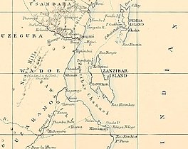
Zanzibar is an insular semi-autonomous province which united with Tanganyika in 1964 to form the United Republic of Tanzania. It is an archipelago in the Indian Ocean, 25–50 km (16–31 mi) off the coast of the African mainland, and consists of many small islands and two large ones: Unguja and Pemba Island. The capital is Zanzibar City, located on the island of Unguja. Its historic centre, Stone Town, is a World Heritage Site.

Pemba Island is a Tanzanian island forming part of the Zanzibar Archipelago, lying within the Swahili Coast in the Indian Ocean.

Mafia Island is an island and district of Pwani Region, Tanzania. The island is the third largest in Tanzanian ocean territory, but is not administratively included within the semi-autonomous region of Zanzibar, which has been politically separate since 1890. Mafia Island forms the major part of Mafia District, one of the six administrative districts in the Pwani coastal region. The local archipelago and the main island are sometimes called Chole shamba in Swahili, hinterlands of the former maintown of Chole on Mafia Bay.
Unguja South Region, Zanzibar South Region or South Zanzibar Region is one of the 31 regions of Tanzania. The region covers an area of 854 km2 (330 sq mi). The region is comparable in size to the combined land area of the nation state of Kiribati. and the administrative region is located entirely on the island of Zanzibar. Unguja South Region is bordered on three sides to the south by Indian Ocean, northeast by Unguja North Region and northwest by Mjini Magharibi Region. The regional capital is the town of Koani. Besides being known for its Spinner dolphin populations, the region is also home to the oldest mosque in East Africa, the Kizimkazi Mosque and also historic Makunduchi town. According to the 2012 census, the region has a total population of 94,504.
Auhah Island is a small island belonging to Kuwait. It is 800 metres (2,625 ft) long by 540 metres (1,772 ft) wide, which corresponds to an area of about 34 hectares, and is located 4 km (2 mi) south-east of Failaka Island, and 33 km (21 mi) from Salmiya on the mainland. Apart from a lighthouse and a small heliport, the island is uninhabited.
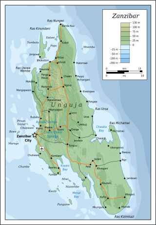
Unguja is the largest and most populated island of the Zanzibar archipelago, in Tanzania.

Pangavini Island is an uninhabited Tanzanian island in the Zanzibar Channel, about 1.5 km off the mainland, north of the country's capital city, Dar es Salaam and is one of the nine islands of the Dar es Salaam Marine Reserve System (DMRS).
The island is small, only about 250 m long; it has a rocky coastline without beaches.

Pangani Town is a historic Swahili settlement located on the south eastern shore of Tanga Region, Tanzania. The town lies 45 km (28 mi) south of the city of Tanga, at the mouth of the Pangani River. It is the headquarters of the Pangani District. Administrately the town Pangani is situated within two wards, Pangani Mashariki and Pangani Magharibi. The town is currently the largest settlement in Pangani district and is a major tourist attraction in Tanga region and is a Tanzanian National Histotic Site.
The Väinameri or Väinameri Sea is a strait and sub-bay of the Baltic Sea, located between the West Estonian Archipelago and the Estonian mainland, within western Estonia.

Makunduchi is a historic town and district capital in the Kusini District of the Unguja South Region in Tanzania. It is located inside the Kajengwa ward, and Mtegani ward, occupying Kiongoni neighboorhood, Nganani neighborhood and Kijini neighborhood. The town comprises two distinct settlements, about 2 km from each other, "Old Makunduchi" on the east and "New Makunduchi". Old Makunduchi is a small fishermen's village on the shore of the Indian Ocean with the Nganani mtaa (neighborhood), while New Makunduchi has some modern buildings, shops, as well as some blocks of flats that were built in the 1970s with the aid of East Germans inreturn for Tanzanian political support internationally. The town is also the birthplace and resting place for the 4th president of Zanzibar Idris Abdul Wakil. Makunduchi is also the birthplace of Samia Suluhu Hassan, the president of Tanzania. Other famous politicians for Makunduchi include Mohamed Gharib Bilal. Also famous novelist Muhammed Said Abdulla.

The Chumbe Lighthouse is located in Chumbe Island in Zanzibar.
The Matumbi Lighthouse is located at the south western tip of Pemba, in Tanzania. The lighthouse is on a small island called Matumbi Makubwa. The lighthouse's construction history is unknown, however, the 31m square stone tower was renovated in 2002 by Salem Construction limited from Zanzibar.
The Ras Makunduchi Lighthouse is located at the south eastern tip of Kusini District Unguja South Region of Tanzania. The lighthouse is located near the historic town of Makunduchi. It is a 27m squared concrete tower painted red and white. The tower has 165 steps to the top and has two non resident operators. Since the lighthouse is on Zanzibar, it is managed by the Zanzibar Ports Corporation instead of the Tanzania Ports Authority.
The PungumeLighthouse is located on Pungume Island at the south western tip of the Zanzibar Archipelago, in Tanzania. The Lighthouse is a squared stone tower recently painted with black and white stripes. The lighthouse is an important one as it shines into the channel where ships enter the Stone Town harbor. The lighthouse is managed and operated by the Zanzibar Ports Corporation.
The Mangapwani Lighthouse is located in Bumbwini, Zanzibar, Tanzania. The lighthouse is one of the oldest lighthouses on the island and is a square stone tower, painted with black and white horizontal bands. The lighthouse is near the Mangapwani slave caves, which were built after the slave trade was abolished in 1873. According to a July 2008 article in Lighthouse Digest, the lighthouse is area is abandoned and stripped by vandals.

Isola delle Correnti Lighthouse is an active lighthouse located on an islet, 277 metres (909 ft) long and 152 metres (499 ft) wide, connected to mainland by a rocky isthmus on the southernmost tip of Sicily in the municipality of Portopalo di Capo Passero on the Malta Channel.

La Rocchetta Lighthouse is an active lighthouse located on the southern part of the promontory of Piombino overlooking the Piombino Channel which separates the Elba from the mainland.

Margaret Brock Reef is a reef in the Australian state of South Australia located in the state's coastal waters on its south-east coast about 7 kilometres (4.3 mi) west of the headland of Cape Jaffa and about 27.2 kilometres (16.9 mi) south-west of the town of Kingston SE. It is the site of both a navigation aid which operated as a staffed lighthouse from 1872 to 1973 and as an automatic beacon onward to the present day, and a rock lobster sanctuary declared under state law in 1973. It is named after the barque Margaret Brock which was wrecked there in 1852.