The Arabian Sea is a region of the northern Indian Ocean bounded on the north by Pakistan, Iran and the Gulf of Oman, on the west by the Gulf of Aden, Guardafui Channel and the Arabian Peninsula, on the southeast by the Laccadive Sea and the Maldives, on the southwest by Somalia, and on the east by India. Its total area is 3,862,000 km2 (1,491,000 sq mi) and its maximum depth is 4,652 meters (15,262 ft). The Gulf of Aden in the west connects the Arabian Sea to the Red Sea through the strait of Bab-el-Mandeb, and the Gulf of Oman is in the northwest, connecting it to the Persian Gulf.

Zanzibar is an insular autonomous region of Tanzania. It is composed of the Zanzibar Archipelago in the Indian Ocean, 25–50 kilometres (16–31 mi) off the coast of the mainland, and consists of many small islands and two large ones: Unguja and Pemba Island. The capital is Zanzibar City, located on the island of Unguja. Its historic centre, Stone Town, is a World Heritage Site.

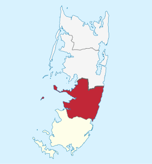
Pemba Island is a Tanzanian island forming part of the Zanzibar Archipelago, lying within the Swahili Coast in the Indian Ocean.

Masirah Island, also referred to as Mazeira Island or Wilāyat Maṣīrah, is an island off the east coast of mainland Oman in the Arabian Sea, and the largest island of the country. It is 95 km (59 mi) long north–south, between 12 and 14 km wide, with an area of about 649 km2, and a population estimated at 12,000 in 12 villages mainly in the north of the island. Administratively, it forms one of the five provinces of the Ash Sharqiyah South Governorate. Previously it was a province of the Ash Sharqiyah Region. The principal village is Raʾs-Ḥilf in the northern part of the island. It contains a Royal Air Force of Oman air base and a fish factory, as well as a few small towns. Previously, the BBC had a relay facility consisting of both HF and MF broadcasting transmitters stationed there. Most of the island's interior is deserted, with access to the island only possible by a small ferry for cars or by Royal Air Force of Oman Airbus A320 or Lockheed C-130 Hercules flights.

The Red Sea Riviera, Egypt's eastern coastline along the Red Sea, consists of resort cities on the western shore of the Gulf of Aqaba and along the eastern coast of mainland Egypt, south of the Gulf of Suez. The combination of a favorable climate, warm sea, thousands of kilometers of shoreline and abundant natural and archaeological points of interest makes this stretch of Egypt's coastline a popular national and international tourist destination. There are numerous National Parks along the Red Sea Riviera, both underwater and on land. Desert and marine life are protected by a number of laws, and visitors may be subject to heavy fines for not abiding.

The Zanzibar Archipelago consists of several islands lying off the coast of East Africa south of the Somali sea. The archipelago is also known as the Spice Islands. There are four main islands, three primary islands with human populations, a fourth coral island that serves as an essential breeding ground for seabirds, plus a number of smaller islets that surround them and an isolated tiny islet.
Chake-Chake is a city located on the Tanzanian island of Pemba. It is in the centre of a deep indentation in the west coast called Chake-Chake Bay.
Bomberai Peninsula is located in the Western New Guinea region, opposite to and to the south of the Bird's Head Peninsula. To the west lies the Sebakor Bay and to the south Kamrau Bay. Sabuda island lies off the western tip of the peninsula, and is separated from the mainland by Berau and Bintuni straits.

Mbweni is a town on the Tanzanian island of Unguja, the main island of Zanzibar. It is located on the central west coast, seven kilometres south of the Zanzibari capital of Stone Town.
Bububu is a town on the Tanzanian island of Unguja, the main island of Zanzibar. It is located on the central west coast, 10 kilometres north of the Zanzibari capital of Stone Town.

Chambani is a village on the Zanzibari island of Pemba. It is located in the south of the island, nine kilometres south of Chake-Chake, close to several sets of ruins, notably the Pujini Ruins, a 15th-century citadel, located close to the village of Pujini, two kilometres to the north.
Ngagu is a village on the Zanzibari island of Pemba. It is located at the end of a narrow peninsula known as Ras Mkumbuu, which lies on the west coast immediately to the north of Chake-Chake Bay. The town is located close to the Quanbalu Ruins. Possibly dating from as early as the eighth century, these are the remains of a major trading centre which may have been Africa's oldest Muslim town.
The Ras Mkumbuu Ruins are located on the west coast of the Tanzanian island of Pemba, part of the Zanzibar Archipelago specifically in South Pemba Region. They lie close to the village of Ndagoni at the end of a long narrow peninsula known as Ras Mkumbuu, which lies to the northwest of the town of Chake-Chake.
Fundo Island is located off the northwest coast of Pemba Island, one of the two main islands of Tanzania's Zanzibar Archipelago. It is one of the larger minor islands in the archipelago and the largest of those surrounding Pemba. Fundo Island is nine kilometres in length, though barely a kilometre in width, and is surrounded by a reef.
Ras Mkumbuu is a long narrow peninsula on the central west coast of Pemba Island, one of the two main islands of Tanzania's Zanzibar Archipelago. The town of Chake-Chake, one of the island's main population centres, is located immediately to the south of it on Chake-Chake Bay. The peninsula stretches due west for 12 kilometres, tapering to only a few tens of metres wide at its narrowest point. The peninsula, along with Fundo Island to the north, forms part of a natural breakwater which provides a calm harbour for the northern town of Wete.
Jozani is a village on the Tanzanian island of Unguja. It is located in the southeast of the island, 3.1 miles south of Chwaka Bay, close to the edge of the Jozani-Chwaka Bay National Park. It is primarily a farming community of about 800 people. located 21.7 miles south-east of Zanzibar Town off the road leading to Paje, Zanzibar. It is easily reached by public buses 309 and 310, by chartered taxi or as an organized tour from Zanzibar Town. These tours are often in combination with dolphin observation in Kizimkazi, one of Zanzibar's oldest settlements with a tiny 12th century mosque open to public. The main road on the island, connecting the west and east coasts of Zanzibar, also connects to Jozani. Besides public bus routes 9, 10 and 13, you can also get here from Zanzibar Town by dala-dala number 309, 310, 324, and 326. Jozani is a small and rural village, situated in the innermost part of the Pete Inlet Bay, immediately south of the Jozani Chwaka Bay National Park. It is one of six rural villages surrounding the park. Residents here depend to a large degree on the Jozani Forest as a source of firewood, hunting, building resources, farming, fishing, and more. The village also operates ecotourism in the Jozani Forest and has constructed a 0.6 mile boardwalk through the mangroves at the southern road entrance into the national park. Many villagers work as authorized guides for tours in the southern tip of Jozani Forest.
Kae is not a village, but the beach of Michamvi village on the Tanzanian island of Unguja, part of Zanzibar. It is one of two villages located in the east of the island at the northern tip of Michamvi Peninsula. It lies on the shore of Chwaka Bay, immediately to the west of the village of Pingwe.

The People's Bank of Zanzibar (PBZ) is a commercial bank in Tanzania. It is licensed by the Bank of Tanzania, the central bank and national banking regulator.

Nungwi, or Ras Nungwi, is a large village located in the far northern end of the island of Zanzibar. With a population of about 5,563, Nungwi is the second- or third-largest settlement on the island, possibly smaller than Makunduchi. It is situated in the Nungwi Ward in the Kaskazini A District of the Unguja North Region. It is about 35 miles (56 km) north of Zanzibar Town on the Nungwi Peninsula, about an hour drive from Stone Town. To the south Nungwi shares a border with the neighboring Matemwe- and Tazari villages. Nungwi was traditionally a fishing village and dhow-building center, but is now a popular tourist destination, and for instance recognized in CNN’s list of "100 best beaches of the world" in 2014. West Nungwi has changed a lot since the 1990s and is now a popular tourist destination with numerous resorts, restaurants, bars, stores, etc. East Nungwi is quieter and generally more laid-back.

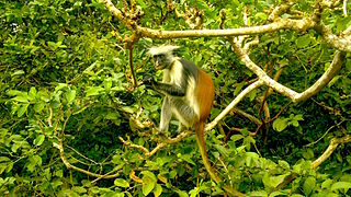
The wildlife of Zanzibar consists of terrestrial and marine flora and fauna in the archipelago of Zanzibar, an autonomous region of Tanzania. Its floral vegetation is categorized among the coastal forests of eastern Africa as the Southern Zanzibar-Inhambane coastal forest mosaic and the Northern Zanzibar-Inhambane coastal forest mosaic. Its faunal species are mostly small animals, birds, and butterflies.