The Strait of Georgia or the Georgia Strait is an arm of the Salish Sea between Vancouver Island and the extreme southwestern mainland coast of British Columbia, Canada and the extreme northwestern mainland coast of Washington, United States. It is approximately 240 kilometres (150 mi) long and varies in width from 20 to 58 kilometres. Along with the Strait of Juan de Fuca and Puget Sound, it is a constituent part of the Salish Sea.
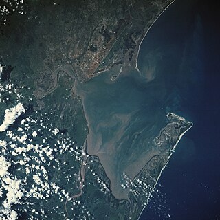
Maputo Bay, formerly also known as Delagoa Bay from Baía da Lagoa in Portuguese, is an inlet of the Indian Ocean on the coast of Mozambique, between 25° 40' and 26° 20' S, with a length from north to south of over 90 km long and 32 km wide.
Sechelt is a district municipality located on the lower Sunshine Coast of British Columbia. Approximately 50 km northwest of Vancouver, it is accessible from mainland British Columbia by a 40-minute ferry trip between Horseshoe Bay and Langdale, and a 25-minute drive from Langdale along Highway 101, also known as the Sunshine Coast Highway. The name Sechelt is derived from the Sechelt language word, shishalh, the name of the First Nations people who first settled the area thousands of years ago.

The Nova Scotia peninsula is a peninsula on the Atlantic coast of North America.
Eva-Liv Island, alternatively transcribed as Yeva-Liv Island, and also known as Eva Island, is the northeasternmost island in Franz Josef Land, Arkhangelsk Oblast, Russian Arctic.
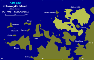
Kolosovykh Island is an island, in the Kara Sea off the coast of Siberia.

Taymyr Island is a large island in the coast of the Kara Sea. Its length is 33 km (21 mi) and its average width about 10 km (6.2 mi). This island is located west of the Taymyr Gulf in an area of skerries right off the western coast of the Taymyr Peninsula. The narrow strait between Taymyr island and the Siberian coast is called Proliv Taymyrskiy It is about 3 km (1.9 mi) wide on average.

The Isuledda, also called Isola dei Gabbiani, is an almost-island in northern Sardinia, Italy, facing the Sardinian channel. Covering an area of approximately 180,000 m², it is almost completely surrounded by the sea, and connected to the mainland by a narrow isthmus of sandy terrain, hence, despite the name, it is in fact a peninsula. It is situated close to the località of Porto Pollo and Barrabisa.
Hall Land is a peninsula in far northwestern Greenland. It is a part of the Northeast Greenland National Park. Hall Land is one of the coldest places in Greenland.

The Remote Peninsula is a peninsula located on the eastern coast of Baffin Island. It is part of the Qikiqtaaluk Region of the Canadian territory of Nunavut. The Inuit settlement of Pond Inlet is 295 km (183 mi) to the northwest and Clyde River is 90 km (56 mi) to the southeast.
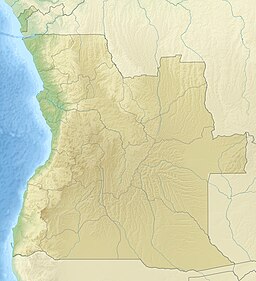
Tigres Island is an island in Angola. It is situated in the Namibe Province.
Baía de Namibe or Little Fish Bay is a bay in Angola. It is located in the Namibe Province.

Baia de Santa Marta, also known as Baía das Luciras or Espiegle Bay, is a bay in Angola. It is located in the Namibe Province.
Porto Alexandre, occasionally known in English as Port Alexander, is a bay in Angola. It is located in the Namibe Province.
Pipas Bay is a bay in Angola. It is located in the Namibe Province, 30 km north of Moçâmedes.
Nyeboe Land is a peninsula in far northwestern Greenland. It is a part of the Northeast Greenland National Park.

Svyatoy Nos is a large peninsula on the eastern edge of Lake Baikal, Eastern Siberia, in the Barguzinsky District of the Republic of Buryatia. It is part of the Zabaykalsky (Trans-Baikal) National Park.

Saint Martin of the Tigers, sometimes referred to simply as Village of Tigres Bay, is a ghost town in southern Angola, located on Tigres Island, currently separated from the Angolan mainland by the Tigres Strait. For legal purposes it is also a commune in the municipality of Tômbua, in the province of Namibe.