The Arabian Sea is a region of sea in the northern Indian Ocean, bounded on the west by the Arabian Peninsula, Gulf of Aden and Guardafui Channel, on the northwest by Gulf of Oman and Iran, on the north by Pakistan, on the east by India, and on the southeast by the Laccadive Sea and the Maldives, on the southwest by Somalia. Its total area is 3,862,000 km2 (1,491,000 sq mi) and its maximum depth is 4,652 meters. The Gulf of Aden in the west connects the Arabian Sea to the Red Sea through the strait of Bab-el-Mandeb, and the Gulf of Oman is in the northwest, connecting it to the Persian Gulf.

Cape Guardafui is a headland in the autonomous Puntland region in Somalia. Coextensive with Puntland's Gardafuul administrative province, it forms the geographical apex of the Horn of Africa. Its shore at 51°27'52"E is the second easternmost point on mainland Africa after Ras Hafun. The offshore oceanic strait Guardafui Channel is named after it.

Pemba Island is a Tanzanian island forming part of the Zanzibar Archipelago, lying within the Swahili Coast in the Indian Ocean.

The Royal Astronomical Society (RAS) is a learned society and charity that encourages and promotes the study of astronomy, solar-system science, geophysics and closely related branches of science. Its headquarters are in Burlington House, on Piccadilly in London. The society has over 4,000 members, known as fellows, most of whom are professional researchers or postgraduate students. Around a quarter of Fellows live outside the UK.

Sharm El Sheikh, alternatively rendered Sharm el-Sheikh, Sharm el Sheikh, or Sharm El-Sheikh, is an Egyptian city on the southern tip of the Sinai Peninsula, in South Sinai Governorate, on the coastal strip along the Red Sea. Its population is approximately 73,000 as of 2023. Sharm El Sheikh is the administrative hub of Egypt's South Sinai Governorate, which includes the smaller coastal towns of Dahab and Nuweiba as well as the mountainous interior, St. Catherine and Mount Sinai. The city and holiday resort is a significant centre for tourism in Egypt, while also attracting many international conferences and diplomatic meetings. Sharm El Sheikh is one of the Asian cities of Egypt.

Ras Al Khaimah (RAK) is one of the seven emirates that make up the United Arab Emirates (UAE). The city of Ras Al Khaimah, abbreviated to RAK or RAK City, is the capital of the emirate and home to most of the emirate's residents. It is linked to the Islamic trading port of Julfar. Its name in English means "headland of the tent". The emirate borders Oman's exclave of Musandam, and occupies part of the same peninsula. It covers an area of 2,486 km2 (960 sq mi) and has 64 km (40 mi) of beach coastline. As of 2015, the emirate had a population of about 345,000.

Gregory Anthony Isaacs OD was a Jamaican reggae musician. Milo Miles, writing in The New York Times, described Isaacs as "the most exquisite vocalist in reggae".

Alan Daniel Maman, professionally known as the Alchemist, is an American hip hop producer, DJ, rapper, and entrepreneur. He began his music career in 1991 in the hip hop duo the Whooliganz under the moniker Mudfoot, along with now-actor Scott Caan. He has produced music since the 1990s.
Ras Tanura is a city in the Eastern Province of Saudi Arabia located on a peninsula extending into the Persian Gulf. The name Ras Tanura applies both to a gated Saudi Aramco employee compound and to an industrial area further out on the peninsula that serves as a major oil port and oil operations center for Saudi Aramco, the largest oil company in the world. Today, the compound has about 3,200 residents, with a few Americans and British expats.

Masirah Island, also referred to as Mazeira Island or Wilāyat Maṣīrah, is an island off the east coast of mainland Oman in the Arabian Sea, and the largest island of the country. It is 95 km (59 mi) long north–south, between 12 and 14 km wide, with an area of about 649 km2, and a population estimated at 12,000 in 12 villages mainly in the north of the island. It is divided from the mainland by the Masirah Channel.
Foul Bay is a bay on the Egyptian side of the Red Sea, in the Red Sea Governorate.

Ras Muhammad is a national park in Egypt at the southern extreme of the Sinai Peninsula, overlooking the Gulf of Suez on the west and the Gulf of Aqaba to the east. The park is becoming a center of eco-tourism in the region.

The Red Sea Riviera, Egypt's eastern coastline along the Red Sea, consists of resort cities on the western shore of the Gulf of Aqaba and along the eastern coast of mainland Egypt, south of the Gulf of Suez. The combination of a favorable climate, warm sea, thousands of kilometers of shoreline, and abundant natural and archaeological points of interest makes this stretch of Egypt's coastline a popular national and international tourist destination. There are numerous National Parks along the Red Sea Riviera, both underwater and on land. Desert and marine life are protected by several laws, and visitors may be subject to heavy fines for not abiding.
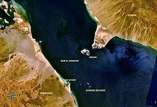
Ras Siyyan or Ras Siyan is a peninsula in the Obock Region of Djibouti, on the Bab-el-Mandeb strait, about 20 km southwest of Perim Island.
Fomm ir-Riħ, is a small bay in the limits of Mġarr on the western side of the island of Malta. The area is characterised by a fault line which creates an interesting landscape with vertical cliffs and a pebble beach. There is also an unusual syncline behind the beach.

Dubai Creek has been described as a natural saltwater creek, tidal inlet, and watercourse or waterway in Dubai, United Arab Emirates (UAE). It extends about 9 miles (14 km) inwards and forms a natural port that has traditionally been used for trade and transport. The creek ranges from 200 to 1,200 metres in width while the average depth is about 6.5 to 7 metres. Previously, it extended to Ras Al Khor Wildlife Sanctuary but as part of the new Business Bay Canal and Dubai Canal, it extends a further 13 km (8.1 mi) to the Persian Gulf.

Al Jazirah Al Hamra is a town to the south of the city of Ras Al Khaimah in the United Arab Emirates. It is known for its collection of abandoned houses and other buildings, including a mosque, which is widely believed locally to be haunted. The town was ruled by the Zaab tribe, which was rehoused in Abu Dhabi following a dispute with the Ruler of Ras Al Khaimah.

The Trucial States, also known as the Trucial Coast, the Trucial Sheikhdoms, Trucial Arabia or Trucial Oman, was a group of tribal confederations to the south of the Persian Gulf whose leaders had signed protective treaties, or truces, with the United Kingdom between 1820 and 1892.

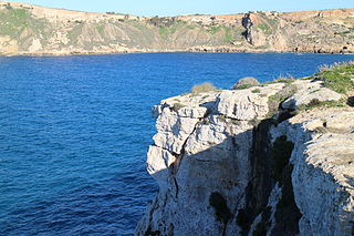
Ras ir-Raħeb, known also as Ras il-Knejjes is a scenic limestone promontory in north western Malta, close to the hamlet of Baħrija. The headland is located in the administrative area of the council of Rabat. Ras ir-Raħeb lies in the north western corner of the Rabat-Dingli-Mdina plateau, just off Fomm ir-Riħ Bay. It rises to 45 metres above sea level. The peak allows views of the west coast of the island, as far as the cliffs of Ta' Ċenċ in Gozo. A wide variety of vegetation grows on the headland, including large populations of esparto grass on the clay slopes in the area. The headland also serves as a navigational marker.
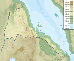
Bay of Beylul or Bēylul Bahir Selat'ē, also known as Badi Bay, is a bay on the Red Sea, on the coast of Eritrea. The bay is located about 450 km southeast of Asmara.