Pwani Region

Last updated
Pwani Region
Mkoa wa Pwani (Swahili)
Overhead view of the coastal area of Bagamoyo.jpg
Vikindu Coconuts.jpg
Architectural Detail - Bagamoyo - Tanzania - 01.jpg
From top to bottom:
Bird's eye view of Bagamoyo District, Coconut landscape of Mkuranga District and Bagamoyo
Etymology: The Coast
Nickname: 
Beautiful Pwani
Tanzania Pwani location map.svg
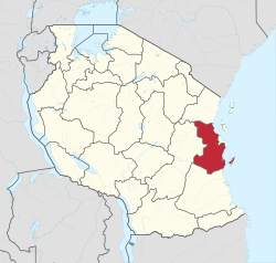
Location in Tanzania
Coordinates: 7°19′25.68″S38°49′13.8″E / 7.3238000°S 38.820500°E / -7.3238000; 38.820500
CountryFlag of Tanzania.svg Tanzania
ZoneCoastal
Administrative Region1972
Capital Kibaha
Districts
Government
  Regional CommissionerAbubakar Kunenge
Area
  Total
32,547 km2 (12,566 sq mi)
  Rank 13th of 31
Highest elevation
(Pongwe)
874 m (2,867 ft)
Population
 (2022)
  Total
2,024,947
  Rank 15th of 31
  Density62/km2 (160/sq mi)
Demonym Pwanian
Ethnic groups
  Settler Swahili
  Native Zaramo, Ndengereko, Rufiji, Kwere, Doe & Zigua
Time zone UTC+3 (EAT)
Postcode
61xxx
ISO 3166 code TZ-19
HDI (2021)0.525 [1]
low · 16th of 25
Website Official website
SymbolsofTanzania
Bird
Crowned Hawk-Eagle (Stephanoaetus coronatus) with prey ... (31850405640).jpg
African crowned eagle
Butterfly
Gold-banded Forester - Euphaedra neophron, Gorongosa National Park, Mozambique (30633313408).jpg
Gold banded forester
Fish
Whale shark Georgia aquarium.jpg
Whale shark
Mammal
Kobus ellipsiprymnus (Kruger, 2012).jpg
Waterbuck
Tree
Mangoes during the end of Autumn season in Hyderabad (2).jpg
Mango
Mineral
Kaolinite Ixtassou MNHN Geologie.jpg
Kaolin

Pwani Region (Swahili: Mkoa wa Pwani) is one of Tanzania's 31 administrative regions. The Swahili word pwani means 'coast'. With the town of Kibaha serving as the capital, the region borders the Tanga Region to the north, Morogoro Region to the west, Lindi Region to the south, and surrounds Dar es Salaam Region to the east. The Indian Ocean also borders the region to its northeast and southeast. The region is home to Mafia Island, the Rufiji delta and Saadani National Park. The region is home to Bagamoyo town, a historical Swahili settlement, and the first colonial capital of German East Africa. According to the 2012 national census, the region had a population of 1,098,668, which was slightly lower than the pre-census projection of 1,110,917. [2] :page 2 From 2002 to 2012, the region's 2.2 percent average annual population growth rate was the seventeenth-highest in the country. [2] :page 4 It was also the 21st most densely populated region with 34 people per square kilometre. [2] :page 6 [3] According to the 2022 census the population had nearly doubled to 2,024,947. [4] The region is slightly larger than Belgium (32,133 square kilometres (12,407 sq mi)).

Contents

Population

The native peoples of the Pwani Region are the Zaramo, Kwere, Doe, Ndengereko, Zigua, and Rufiji. The Zaramo are the dominant people group in Pwani Region and are native to central Pwani, specifically in Kisarawe, Kibaha, Mkuranga, and Bagamoyo districts. The second-largest group in terms of the territory is the Rufiji people who are native to Rufiji and Kibiti districts. The Kwere and Doe are native to Bagamoyo District and also southern Zigua people. In 2012, the region had 1,098,668 residents, up from 885,017 in the 2002 Population Census, indicating a considerable increase of 213,651 individuals (24.1%) during the intercensal period. The region has a population of 2.5 percent of Tanzania's overall population. When compared to other regions on the Mainland, the Coast Region ranks fifth least populated, followed by Iringa, Lindi, Njombe, and Katavi. Between 1988 and 2002, the population of the Pwani Region increased at a rate of 2.4 percent each year. Between 2002 and 2012, the annual growth rate fell to an average of 2.2 percent. [5]

CensusPopulation [4]
1978516,586
1988636,103
2002885,017
20121,098,668
20222,024,947
Zaramo Dance 1960s The National Archives UK - CO 1069-166-97.jpg
Zaramo Dance 1960s
Brooklyn Museum 1991.228.2 Zaramo Container Brooklyn Museum 1991.228.2 Container.jpg
Brooklyn Museum 1991.228.2 Zaramo Container

Economy

Agriculture remains the mainstay of the Pwani Region's economy. Commercial and peasant farming are practiced, with the latter taking precedence. Crop farming employed 82 percent of the economically active population in the 2007/08 Coast area agriculture sample census report, followed by livestock husbandry (2 percent), and fishing (2%). The remaining 12% worked in non-farming activities such as trade and repairs. Agriculture generates the majority of the region's monetary income, primarily through the sale of coconuts, oranges, mango, and cassava on a large scale. [6]

Administrative divisions

Districts

As of 2012, Pwani Region is divided into six districts, each administered by a council:

Districts of Pwani Region
Pwani in Tanzania.svg Bagamoyo District 311,740
Kibaha District 128,488
Kibaha Urban District 70,209
Kisarawe District 101,598
Mafia District 46,438
Mkuranga District 222,921
Rufiji District 217,274
Total1,098,668

However, additional districts have been added since 2012; Kibiti District and Chalinze District. [7] [8]

Education

Secondary (high) schools operated by the ministry of education in Pwani Region include:

  1. Kibaha Secondary School (Kibaha District)
  2. Kibiti Secondary School (Rufiji District)
  3. Minaki Secondary School (Kisarawe District) — this school was established in Kisarawe in 1925, as St. Andrews College. Prior to that, it traces its history back to a Universities' Mission to Central Africa mission school established in Kiungani, Zanzibar, in 1869. [9]

Notable people from Pwani Region

References

  1. "Sub-national HDI - Area Database - Global Data Lab". hdi.globaldatalab.org. Archived from the original on 2018-09-23. Retrieved 2020-02-26.
  2. 1 2 3 Population Distribution by Administrative Units, United Republic of Tanzania, 2013 Archived 2013-05-02 at the Wayback Machine
  3. Statistical Abstract 2011, Tanzania National Bureau of Statistics Archived 2013-11-05 at the Wayback Machine
  4. 1 2 "Tanzania: Regions and Cities - Population Statistics, Maps, Charts, Weather and Web Information". www.citypopulation.de. Retrieved 2024-02-09.
  5. "Pwani Population Profile". Archived from the original on 2022-06-15. Retrieved 2022-06-11.
  6. "Pwani Eocnomic Profile". Archived from the original on 2022-06-15. Retrieved 2022-06-11.
  7. "Kibiti District". Archived from the original on 2022-06-10. Retrieved 2022-06-11.
  8. "Chalinze District". Archived from the original on 2022-06-14. Retrieved 2022-06-11.
  9. Cooper-Poole, John; Doro, Marion, eds. (1 January 2006). "Reviews: The Story of Minaki. P M Libaba Second edition 2005, with additions by Peter White". Tanzanian Affairs. 83. Archived from the original on 7 July 2022. Retrieved 23 December 2010.