The country of Brazil occupies roughly half of South America, bordering the Atlantic Ocean. Brazil covers a total area of 8,514,215 km2 (3,287,357 sq mi) which includes 8,456,510 km2 (3,265,080 sq mi) of land and 55,455 km2 (21,411 sq mi) of water. The highest point in Brazil is Pico da Neblina at 2,994 m (9,823 ft). Brazil is bordered by the countries of Argentina, Bolivia, Colombia, Guyana, Paraguay, Peru, Suriname, Uruguay, Venezuela, and France.

The Democratic Republic of the Congo (DRC) is the largest country of sub-Saharan Africa, occupying some 2,344,858 square kilometres (905,355 sq mi). Most of the country lies within the vast hollow of the Congo River basin. The vast, low-lying central area is a plateau-shaped basin sloping toward the west, covered by tropical rainforest and criss-crossed by rivers. The forest center is surrounded by mountainous terraces in the west, plateaus merging into savannas in the south and southwest. Dense grasslands extend beyond the Congo River in the north. High mountains of the Ruwenzori Range are found on the eastern borders with Rwanda and Uganda.

Ecuador is a country in western South America, bordering the Pacific Ocean at the Equator, for which the country is named. Ecuador encompasses a wide range of natural formations and climates, from the desert-like southern coast to the snowcapped peaks of the Andes mountain range to the plains of the Amazon Basin. Cotopaxi in Ecuador is one of the world's highest active volcanos. It also has a large series of rivers that follow the southern border and spill into the northwest area of Peru.

India is situated north of the equator between 8°4' north to 37°6' north latitude and 68°7' east to 97°25' east longitude. It is the seventh-largest country in the world, with a total area of 3,287,263 square kilometres (1,269,219 sq mi). India measures 3,214 km (1,997 mi) from north to south and 2,933 km (1,822 mi) from east to west. It has a land frontier of 15,200 km (9,445 mi) and a coastline of 7,516.6 km (4,671 mi).

The Geography of Kenya is diverse, varying amongst its 47 counties. Kenya has a coastline on the Indian Ocean, which contains swamps of East African mangroves. Inland are broad plains and numerous hills. Kenya borders South Sudan to the northwest, Uganda to the west, Somalia to the east, Tanzania to the south, and Ethiopia to the north.

Tanzania comprises many lakes, national parks, and Africa's highest point, Mount Kilimanjaro. Northeast Tanzania is mountainous, while the central area is part of a large plateau covered in grasslands. The country also contains the southern portion of Lake Victoria on its northern border with Uganda and Kenya.

The Limpopo River rises in South Africa and flows generally eastward through Mozambique to the Indian Ocean. The term Limpopo is derived from Rivombo (Livombo/Lebombo), a group of Tsonga settlers led by Hosi Rivombo who settled in the mountainous vicinity and named the area after their leader. The river is approximately 1,750 kilometres (1,087 mi) long, with a drainage basin 415,000 square kilometres (160,200 sq mi) in size. The mean discharge measured over a year is 170 m3 per second at its mouth. The Limpopo is the second largest river in Africa that drains to the Indian Ocean, after the Zambezi River.

A drainage basin is an area of land where all flowing surface water converges to a single point, such as a river mouth, or flows into another body of water, such as a lake or ocean. A basin is separated from adjacent basins by a perimeter, the drainage divide, made up of a succession of elevated features, such as ridges and hills. A basin may consist of smaller basins that merge at river confluences, forming a hierarchical pattern.

The Eastern Continental Divide, Eastern Divide or Appalachian Divide is a hydrographic divide in eastern North America that separates the easterly Atlantic Seaboard watershed from the westerly Gulf of Mexico watershed. The divide nearly spans the United States from south of Lake Ontario through the Florida peninsula, and consists of raised terrain including the Appalachian Mountains to the north, the southern Piedmont Plateau and lowland ridges in the Atlantic Coastal Plain to the south. Water including rainfall and snowfall, lakes, streams and rivers on the eastern/southern side of the divide drains to the Atlantic Ocean; water on the western/northern side of the divide drains to the Gulf of Mexico. The ECD is one of six continental hydrographic divides of North America which define several drainage basins, each of which drains to a particular body of water.

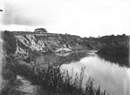
The Rufiji River lies entirely within Tanzania. It is also the largest and longest river in the country. The river is formed by the confluence of the Kilombero and Luwegu rivers. It is approximately 600 kilometres (370 mi) long, with its source in southwestern Tanzania and its mouth on the Indian Ocean opposite Mafia Island across the Mafia Channel, in Pwani Region. Its principal tributary is the Great Ruaha River. It is navigable for approximately 100 kilometres (62 mi).

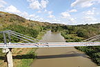
Periyar, IPA: [peɾijɐːr], is the longest river and the river with the largest discharge potential in the Indian state of Kerala. It is one of the few perennial rivers in the region and provides drinking water for several major towns. The Periyar is of utmost significance to the economy of Kerala. It generates a significant proportion of Kerala's electrical power via the Idukki Dam and flows along a region of industrial and commercial activity. The river also provides water for irrigation and domestic use throughout its course besides supporting a rich fishery. Due to these reasons, the river has been named the "Lifeline of Kerala". Kochi city, in the vicinity of the river mouth draws its water supply from Aluva, an upstream site sufficiently free of seawater intrusion. Twenty five percent of Kerala's industries are along the banks of river Periyar. These are mostly crowded within a stretch of 5 kilometres (3 mi) in the Eloor-Edayar region (Udhyogamandal), about 10 kilometres (6 mi) north of Kochi harbor.
The Nguru Mountains are a mountain range in Morogoro Region, Tanzania, Africa. They are part of the Eastern Arc Mountains. The mountains are predominantly covered with rainforest, home to 83 species of birds and African violets. Several forest reserves are located in the mountains.
The Udzungwa Mountains are a mountain range in south-central Tanzania. The mountains are mostly within Iringa Region, south of Tanzania's capital Dodoma. The Udzungwa Mountains are part of the Eastern Arc Mountains, and are home to a biodiverse community of flora and fauna with large numbers of endemic species.
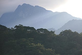
The Uluguru mountains are a mountain range in eastern Tanzania, named after the Luguru tribe. The main portion of the Uluguru mountains is a ridge running roughly north-south and rising to 2,630 metres (8,600 ft) altitude at its highest point. On the main Uluguru range, 50 villages touch the forest boundary and over 151,000 people are found within the mountain area, often at increasing densities at higher altitudes up to the forest boundary.
The Ulanga River, also known as the Kilombero River, rises in the highlands of the southwest of Morogoro Region, Tanzania, on the eastern slope of the East African Rift. The river flows northeast along the northeastern border of the Lindi Region before it flows into the Rufiji River. The Rufiji eventually flows into the Indian Ocean on the southern coast of the Pwani Region.
The Southern Highlands is a highland region in southwestern Tanzania, at the northern end of Lake Malawi. The highlands include portions of Mbeya, Njombe, Rukwa, Ruvuma, and Songwe regions, bordering Malawi, Mozambique, and Zambia. Mbeya is the largest city in the highlands.

The Sahibi river, also called the Sabi River, is an ephemeral, rain-fed river flowing through Rajasthan, Haryana and Delhi states in India. It originates in the eastern slopes of the Saiwar Protected Forest (PF) hills in Sikar District, enters Jaipur district near the foot of these hills, and after initially flowing southeast and east turns northeastwards near Shahpura and continues further till it exits Rajasthan to enter Haryana and further drains into Yamuna in Delhi, where its channeled course is also called the Najafgarh drain, which also serves as Najafgarh drain bird sanctuary. It flows for 300 km of which 157 km is in Rajasthan 100 km is in Haryana and 40 km in Delhi.
The Nguu Mountains are a mountain range in Tanga Region of Tanzania. The Nguu Mountains are part of the Eastern Arc Mountains. The mountains are covered in woodland, grassland, and forest.
Malundwe Mountain, also known as Malundwe Hill, is a mountain in Tanzania. It is located in Mikumi National Park in Morogoro Region.

The Ruvu River is a river in eastern Tanzania.