Rubeho Mountains

Last updated
Rubeho Mountains
Tanzania relief location map.svg
Red triangle with thick white border.svg
Location in Tanzania
Highest point
Peak Mangalisa
Elevation 2,286 m (7,500 ft)
Geography
Country Tanzania
Range coordinates 07°01′S36°42′E / 7.017°S 36.700°E / -7.017; 36.700 Coordinates: 07°01′S36°42′E / 7.017°S 36.700°E / -7.017; 36.700
Parent range Eastern Arc Mountains
Borders on Ukaguru Mountains

The Rubeho Mountains are a mountain range in central Tanzania. The mountains in Dodoma and Morogoro regions, southeast of Tanzania's capital Dodoma. The Rubeho Mountains are part of the Eastern Arc Mountains, and are home to a biodiverse community of flora and fauna with large numbers of endemic species.

Contents

Geography

The Rubeho Mountains are a dissected plateau, covering an area of 4636 km². [1] The highest peaks in the range are Mangalisa (2,286 m), Mafwemiro (2,152 m) and Ledengombe (1,941 m). [2] On the south, the steep-sided valley of the Great Ruaha River separates the Rubheho Mountains from the Udzungwa Mountains. On the southeast a narrow gap separates the Rubeho Mountains from Uvidunda Mountains. The Pala Mountains are close to the east, and the Mkata Plain beyond them. The Mkondoa River separates the Rubeho Mountains from the Ukaguru Mountains on the north and northeast. The Wota Mountains, a western outlier of the Rubeho mountains, and East African Plateau lie to the west.

Climate

The Rubeho Mountains intercept moisture-laden winds from the Indian Ocean, and receive more rainfall than the surrounding lowlands. Most of the rainfall occurs in the November-to-May wet season, although mist and light rain occur at higher elevations during the dry season months. Rainfall is higher on the southern and eastern slopes facing the Indian Ocean, and lower in the mountains' rain shadow to the north and west. Temperatures are cooler at higher elevations. [3]

Geology

The Rubeho Mountains, along with the others in the Eastern Arc, are made up of ancient crystalline Precambrian rocks that were uplifted over millions of years along fault lines. The most recent period of uplift started 30 million years ago, but the fault system and uplift process may be far older. Soils derived from these ancient rocks are not as fertile as the younger volcanic soils of mountains to the north and west. [3]

Flora and fauna

About thirty million years ago, the area was covered by extensive rainforest. During a cooler and drier period some ten million years ago, the lowland forests were converted to savanna, leaving the mountain ranges as "islands" where the tropical forests continued to flourish. The long-term persistence of a humid climate and the isolation of each mountain range has led to a great deal of endemism, and a very diverse flora and fauna. [4] The Rubeho and other Eastern Arc mountains have extremely high biodiversity with numerous endemic species (more than 25 percent of the vertebrate species). [5]

The Rubeho Mountains are covered with miombo woodland, dry montane forest, montane grassland, montane rainforest, and Acacia-Commiphora bushlands and thickets. Forests extend from 520 to 2050 meters elevation, and vary in composition and species type with elevation and rainfall. [1] An analysis of satellite images taken between 1999 and 2003 found 464 km² of the mountains were still covered in evergreen forest. [1]

The wetter eastern and southeastern slopes receive more rain from the Indian Ocean and support miombo woodlands at lower elevations, transitional evergreen forests above 520 meters elevation, and montane evergreen forests at higher elevations. [1] Tree species in the montane evergreen forests include Agarista salicifolia, Aphloia theiformis, Bridelia micrantha, Catha edulis, Diospyros whyteana, Halleria lucida, Macaranga kilimandscharica, Maesa lanceolata, Maytenus acuminata, Nuxia congesta, Parinari excelsa, Polyscias fulva, Rapanea melanophloeos , and Xymalos monospora . [6] On the western slopes of the main plateau, Macaranga kilimandscharica is the predominant tree, forming a 10-15-meter canopy in dry montane forests in valleys at 1,600–1,700 meters elevation. [2]

The drier western and northwestern slopes have Acacia-Commiphora bushlands and thickets at lower elevations, and dry montane forests at higher elevations. [2]

The Rubeho warbler (Scepomycter rubehoensis) is a highland songbird endemic to the Rubeho and Uvidunda mountains. Other endemic or near-endemic birds are the Rubeho forest partridge (Xenoperdix obscuratus) and Rubeho akalat (Sheppardia aurantiithorax).

Elephants (Loxodonta africana) and Red forest duikers (Cephalophus natalensis) are found in the forests of the eastern plateau. [2]

Protected areas and conservation

Ukwiva Forest Reserve (54,635 hectares), Mafwemiro Forest Reserve [3,238 hectares], and Mangalisa Forest Reserve [4,988 hectares] are among the protected areas. Ukwiva covers the northeastern portion of the main plateau, and includes the mountains' largest block of evergreen montane forest on the eastern slopes, and dry montane forest at 1,600–1,700 m. Pala Mountain Forest Reserve (108.34 km²) [7] includes the transitional evergreen forests in the Pala Mountains, just east of the main plateau. Mafwemiro is northwest of Ukivwa. Mangalisa is a separate mountain block west of the main plateau, north of the Great Ruaha River. Mangalisa forest reserve includes patches of disturbed dry high-elevation semi-evergreen woodland, and Podocarpus -dominated montane forest in the southern part of the reserve. [2]

Transport

The highway number A7 in Tanzania borders the southern edge of the highlands, following the Big Ruaha River before heading northeast through the Rubeho-Uvidunda mountain gap.. Tanzania Central Line railway skirts the northern end of the mountains, following the Mkondoa River between the Rubeho and the Ukaguru mountains between Dar es Salaam and western Tanzania. At Kilosa the Central Railway's Mikumi line branches south through the Mkata Plain east of the mountains.

Related Research Articles

Eastern Highlands Mountain range in Zimbabwe and Mozambique

The Eastern Highlands, also known as the Manica Highlands, is a mountain range on the border of Zimbabwe and Mozambique. The Eastern Highlands extend north and south for about 300 kilometres (190 mi) through Zimbabwe's Manicaland Province and Mozambique's Manica Province.

The Nguru Mountains are a mountain range in Morogoro Region, Tanzania, Africa. The Nguru Mountains are part of the Eastern Arc Mountains. The mountains are predominantly covered with rainforest, home to 83 species of birds and African violets. There are a number of forest reserves in the mountains.

The Kipengere Range, also known as the Livingstone Mountains, lies entirely in Njombe Region in southwest Tanzania at the northern end of Lake Nyasa. Near Lake Nyasa they are known as the Kinga Mountains. It is a plateau-like ridge of mountains running southeastwards from the basin of the Great Ruaha River in the north to that of the Ruhuhu River in the south, and forms part of the eastern escarpment of the East African Rift. The range is mostly clad in montane grasslands, renowned for their botanical diversity and displays of flowers, with montane evergreen forests mostly in stream valleys.

Udzungwa Mountains Mountain range in south-central Tanzania

The Udzungwa Mountains are a mountain range in south-central Tanzania. The mountains are mostly within Iringa Region, south of Tanzania's capital Dodoma. The Udzungwa Mountains are part of the Eastern Arc Mountains, and are home to a biodiverse community of flora and fauna with large numbers of endemic species.

Mount Rungwe


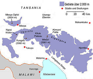
Mount Rungwe is a volcanic mountain in Mbeya Region, in Tanzania's Southern Highlands. At an altitude of 2,981 metres (9,780 ft), it is southern Tanzania's second-highest peak. Rungwe's volcano is currently inactive.

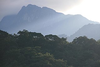
The Uluguru mountains are a mountain range in eastern Tanzania, named after the Luguru tribe. The main portion of the Uluguru mountains is a ridge running roughly north-south and rising to 2,630 metres (8,600 ft) altitude at its highest point. On the main Uluguru range, 50 villages touch the forest boundary and over 151,000 people are found within the mountain area, often at increasing densities at higher altitudes up to the forest boundary.

Eastern Arc Mountains Mountain range in Kenya and Tanzania

The Eastern Arc Mountains is a chain of mountains found in Kenya and Tanzania. The chain runs from northeast to southwest, with the Taita Hills being in Kenya and the other ranges being in Tanzania. They are delimited on the southwest by the fault complex represented by the Makambako Gap that separates them from the Kipengere Range. To the northeast, they are delimited by more recent volcanism represented by Mount Kilimanjaro. The chain is considered a Tentative World Heritage Site.

The Southern Highlands is a highland region in southwestern Tanzania, at the northern end of Lake Malawi. The highlands include portions of Mbeya, Njombe, Rukwa, Ruvuma, and Songwe regions, bordering Malawi, Mozambique, and Zambia. Mbeya is the largest city in the highlands.

Mbulu Highlands

The Mbulu Highlands is a plateau in north-central Tanzania.

Eastern Arc forests

The Eastern Arc forests is a montane tropical moist forest ecoregion of eastern Africa. The ecoregion comprises several separate highland areas above 800 meters in Kenya, and (mostly) Tanzania.

Ethiopian montane forests

The Ethiopian montane forests is a tropical moist broadleaf forest ecoregion in eastern Africa. It covers the middle elevations of the Ethiopian Highlands in Ethiopia and extends into neighboring Eritrea, Sudan, Djibouti, and Somaliland. The ecoregion includes distinctive Afromontane forests, woodlands, grasslands, and shrublands. The ecoregion's biodiversity is threatened by deforestation, conversion to agriculture, and overgrazing.

Rondo Plateau Plateau in Lindi and Mtwara Regions, Tanzania

The Rondo Plateau, also known as the Muera Plateau, is a high and extensive massif in the Lindi Region and northern Mtwara Region of southeastern of Tanzania. A portion of the plateau is protected by the Rondo Forest Reserve. It is one of a group of dissected plateaus lying between the Mbwemburu and Lukuledi rivers. It is approximately 60 km inland from Lindi, and is situated 15 km north of the Masasi road. It was revealed as an important biodiversity site in studies conducted since the 1980s.

The Misuku Hills are a mountain range in Malawi's Northern Region.

The Umalila Mountains are a mountain range in southern Tanzania, on the border with Malawi. The Umalila Mountains are part of Tanzania's Southern Highlands.

Southern <i>Acacia</i>–<i>Commiphora</i> bushlands and thickets

The Southern AcaciaCommiphora bushlands and thickets is a tropical grasslands, savannas, and shrublands ecoregion in Tanzania and Kenya. It includes portions of Serengeti National Park and Ngorongoro Conservation Area, which are designated World Heritage Sites and biosphere reserves for their outstanding wildlife and landscapes. It is one of three Acacia–Commiphora bushlands and thickets ecoregions in eastern Africa.

The Ukaguru Mountains are a mountain range in central Tanzania. The mountains are in Morogoro region, east of Tanzania's capital Dodoma. The mountains are named for the Kaguru people. The Ukaguru Mountains are part of the Eastern Arc Mountains, and are home to a biodiverse community of flora and fauna with large numbers of endemic species.

The Nguu Mountains are a mountain range in Tanga Region of Tanzania. The Nguu Mountains are part of the Eastern Arc Mountains. The mountains are covered in woodland, grassland, and forest.

Southwestern Arabian foothills savanna

The Southwestern Arabian foothills savanna, also known as the Southwestern Arabian Escarpment shrublands and woodlands, is a desert and xeric shrubland ecoregion of the southern Arabian Peninsula, covering portions of Saudi Arabia, Yemen, and Oman.


The Uvidunda Mountains are a mountain range in Tanzania, in Tanzania's Morogoro Region. They are named for the Vidunda people.

Malundwe Mountain, also known as Malundwe Hill, is a mountain in Tanzania. It is located in Mikumi National Park in Morogoro Region.

References

  1. 1 2 3 4 N. D. Burgess et al. (2007). "The biological importance of the Eastern Arc Mountains of Tanzania and Kenya". Biological Conservation 134 (2007) pp. 209–231.
  2. 1 2 3 4 5 BirdLife International (2019) Important Bird Areas factsheet: Rubeho Mountains. Downloaded from http://www.birdlife.org on 12/09/2019.
  3. 1 2 "Eastern Arc forests". World Wildlife Fund ecoregion profile. Accessed 10 September 2019.
  4. Briggs, Philip (2009). Northern Tanzania: The Bradt Safari Guide with Kilimanjaro and Zanzibar. Bradt Travel Guides. pp. 20–21. ISBN   978-1-84162-292-7.
  5. Newmark, W. D., 2002, Conserving Biodiversity in East African Forests, a Study of the Eastern Arc Mountains. Ecological Studies 155. Springer-Verlag, Berlin, p. 197
  6. "Rubeho". Eastern Arc Mountains Conservation and Education Fund (EAMCEF). Accessed 12 September 2019.
  7. "Pala Mountain Forest Reserve". Protected Planet. Accessed 12 September 2019.