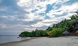
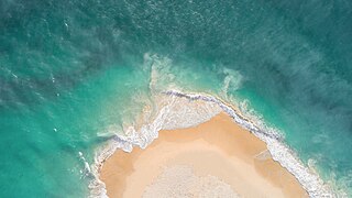
Mafia Island or Chole Shamba is an island of The Mafia Archipelago located in Mafia District in the southern Pwani Region of Tanzania across the Mafia Channel. The island is the third largest in Tanzanian ocean territory, but is not administratively included within the semi-autonomous region of Zanzibar, which has been politically separate since 1890. Mafia Island forms the largest part of Mafia District, one of the six administrative districts in the Pwani Region. As the Mafia Archipelago's main islan, is sometimes called Chole shamba in meaning Chole farmlands Swahili. This is in opposition to the historic settlement of Chole Mjini(Chole town) on Chole Island inside Mafia Bay. The island's population is over 40,000. The economy is based on fishing, subsistence agriculture and the market in Kilindoni. The island attracts some tourists, mainly scuba divers, birdwatchers, game fishermen, and people seeking relaxation.
Bongoyo Island is a protected, uninhabited island under the Dar es Salaam Marine Reserve with the IUCN category II located within Kinondoni District of Dar es Salaam Region in Tanzania. The island situated 2.5 km north of the country's largest city, Dar es Salaam in the Sea of Zanj. It is the most frequently visited of the four islands of the Dar es Salaam Marine Reserve System (DMRS) and a popular daytrip for both tourists and Tanzanian residents alike for snorkelling and sunbathing. North of the island is Mbudya Island and to the west is Pangavini Island. The island is home to some of Tanzania's largest specimens of endangered coconut crabs.
Mbudya Island is a protected, uninhabited island under the Dar es Salaam Marine Reserve with the IUCN category II located within Kinondoni District of Dar es Salaam Region in Tanzania. The island reserve measures around 14.2 km2. Fungu Yasin is to the north of the island, and Bongoyo Island is to the south. The island of Pangavini is to the west. The island is home to endangered coconunt crabs.
The Dar es Salaam Marine Reserve System or DMRS is a group of marine reserves in Tanzania, with the IUCN category II located within Dar es Salaam Region of Tanzania. The reserve system consists of nine uninhabited islands, four located north of Dar es Salaam's Kinondoni District; and four south of the city Makatumbi Islands, Kimbubu Island, Sinda Island and Kendwa Island in Kigamboni District. It provides protection for several important tropical ecosystems; coral reefs, mangroves and seagrass beds.

Pangavini Island is a protected, uninhabited island under the Dar es Salaam Marine Reserve with the IUCN category II located within Kinondoni District of Dar es Salaam Region in Tanzania. The island reserve measures around 2.13km2. Pangavini is the smallest island in the group, only about 250 m long; it has a rocky coastline without beaches. To the west of the island is Kunduchi ward and to the north is Mbudya Island. To the south of the island is Bongoyo Island.
Fungu Yasini Island is a protected, uninhabited island under the Dar es Salaam Marine Reserve (DMRS) with the IUCN category II located within Kinondoni District of Dar es Salaam Region in Tanzania. The island reserve measures around 22.90km2 with most it underwater as a reef. South of the island is Mbudya Island.

Mafia Island Marine Park is a protected marine park with the IUCN category VI around the Mafia Archipelago in the Indian Ocean's sea of Zanj. It is administratively located in the jurisdiction Mafia District of Pwani Region in Tanzania.

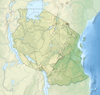
Mafia District Council(Wilaya ya Mafia, in Swahili) is one of six administrative districts of Pwani Region in Tanzania. It administers not only the main Mafia Island but the entire Mafia Archipelago. The District covers an area of 642.6 km2 (248.1 sq mi). The Sea of Zanj completely encircles the District. Rufiji District is located on the other side of the Mafia Channel to the west. The district is comparable in size to the land area of Saint Lucia. The town of Kilindoni serves as its administrative capital. The District is home to the largest concentration of Whale Sharks in Africa, Mafia Island Marine Park, Historic Chole Island Ruins, Kisimani Mafia and Kua Ruins; and Mlola Forest Reserve. According to the 2012 Tanzania National Census, the population of the District was 46,438.

The Marine Park and Reserves Unit of Tanzania was formed in 1994 under the Marine Parks and Reserve Act No 29, of 1994. The headquarters are located in Upanga West ward of Ilala District in Dar es Salaam Region. Previously all marine life and biodiversity was under the Ministry of Livestock and Fisheries. The population along the 1400 km Tanzanian coastline has reached to over 10 million and the increase in number of people whose livelihood depends on the marine resource has also increased. The increase in population has caused various threats to the marine life due to over fishing, coral mining and unplanned increase in settlements. To protect the marine biodiversity the Government of Tanzania established the Marine Park and Reserves unit in 1994 with Mafia Island Marine Park as the first marine park.
The East African coral coast is a marine ecoregion along the eastern coast of Africa. It extends along the coasts of Kenya, Tanzania, and northern Mozambique, from Lamu in Kenya to Angoche in Mozambique. It adjoins the Northern Monsoon Current Coast ecoregion to the north, and the Bight of Sofala/Swamp Coast ecoregion to the south.

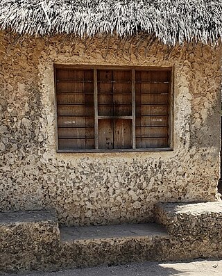
Chole Island Ruins is a national historic site located on Chole Island of Jibondo ward in Mafia District of Pwani Region in Tanzania. The ruined mosques are from the 14th century, whereas other remains that have survived are often considerably more recent, from the 18th century. Even though the remains are in disrepair and are difficult to navigate, the largest standing ruin is a massive double-story building with stone staircases and a labyrinth of anterooms.

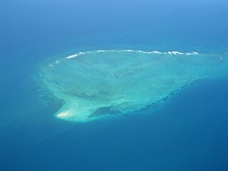
The Mafia Archipelago or The Mafia Islands is an group of islands across the Mafia Channel in the Mafia District of Pwani Region's coast on the Sea of Zanj in Tanzania's Indian Ocean coast. The archipelago is composed of 9 islands and around 12 coral reefs. In total, the Mafia archipelago covers 972 km2 (375 sq mi) in total, of which 8.5 km2 (3.3 sq mi) 407 km2 are land and 565 km2 are water. and has an average elevation of 53 m (174 ft). Of the 12 reefs in the archipelago the most famous one is the Tutia Reef. The nine Islands in the archipelago are. The largest island in the archipelago is Mafia Island also known as Chole Shamba locally. The other eight islands inside Mafia District in addition to Mafia Island are; Juani Island, Chole Island, Jibondo Island (Kibondo), Bwejuu Island, Shungumbili Island (Thanda), Barakuni Island, Miewi Island, and Niororo Island (Nyororo).

Juani Island is an island of the Mafia Archipelago located in Jibondo ward of Mafia District in southern Pwani Region of Tanzania.
Chole Island or Chole Mjini Island is an island of the Mafia Archipelago located in Jibondo ward of Mafia District in southern Pwani Region of Tanzania. A fossil coral reef that was uncovered at the conclusion of the last ice age, around 12,000 years ago, served as the foundation for the 2.26 km2 island of Chole. It has been a part of the Mafia Island Marine Park for a very long time.
Jibondo Island is an island of the Mafia Archipelago located in Jibondo ward of Mafia District in southern Pwani Region of Tanzania. After Juani Island, which is to its east, the island is the third largest in the archipelago. Mafia Island is to the north, and the Mafia Channel is to the west and south. Jibondo ward is named after the island. The island is part of the Mafia Island Marine Park.
Bwejuu Island is an island of the Mafia Archipelago located in Kilindoni ward of Mafia District in southern Pwani Region of Tanzania. After Jibondo Island, which is to its east, the island is the fourth largest in the archipelago. Mafia Island is to the east, and the Mafia Channel is to the west and south of the island.
Shungumbili Island or Shungi Mbili, also more commercially known as Thanda Island is a private island of the Mafia Archipelago located in Kirongwe ward of Mafia District in southern Pwani Region of Tanzania. The island is not a part of the Mafia Island Marine Park.
Tutia Reef is a system of protected coral reefs inside the Mafia Island Marine Park (MIMP) with the IUCN category II designation. The reef is located on Tanzania's Mafia Archipelago of Mafia District in southern Pwani Region of Tanzania. Tutia Reef is rated as the country's top spot for sport fishing, however the reef is aso the site some of the worst coral bleaching events in history in 1998. The reef is located south west of Jibondo Island inside the Mafia Channel.