Dar es Salaam is the largest city and financial hub of Tanzania. It is also the capital of the Dar es Salaam Region. With a population of over six million people, Dar es Salaam is the largest city in East Africa and the sixth-largest in Africa. Located on the Swahili coast, Dar es Salaam is an important economic center and one of the fastest-growing cities in the world.

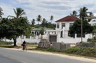
Lindi is a historic southern Tanzanian coastal town and regional capital of the Lindi Region. The town is located at the far end of Lindi Bay on the Indian Ocean in southeastern Tanzania. The town is 450 kilometres (280 mi) south of Dar es Salaam and 105 km (65 mi) north of Mtwara, the southernmost coastal town in Tanzania, and gives its name to the surrounding Lindi Region. The Lindi Region is a large, yet sparsely populated, region of Tanzania.

Dar es Salaam Region is one of Tanzania's 31 administrative regions and is located in the east coast of the country. The region covers an area of 1,393 km2 (538 sq mi). The region is comparable in size to the combined land and water areas of the nation state of Mauritius Dar es Salaam Region is bordered to the east by Indian Ocean and it is entirely surrounded by Pwani Region. The Pwani districts that border Dar es Salaam region are Bagamoyo District to the north, Kibaha Urban District to the west, Kisarawe District to the south west and Mkuranga District to the south of the region. The region's seat (capital) is located inside the ward of Ilala. The region is named after the city of Dar es Salaam itself. The region is home to Tanzania's major finance, administration and industries, thus the making it the country's richest region. The region also has the second highest Human Development Index in the country after Mjini Magharibi. According to the 2022 census, the region has a total population of 5,383,728 and national census of 2012 had 4,364,541. The region has the highest population in Tanzania followed by Mwanza Region.

Ilala District, officially the Ilala Municipal Council is one of five districts of the Dar es Salaam Region of Tanzania. The district is bordered to the north and northeast by Kinondoni District and Ubungo District, to the east by the Zanzibar Channel, the west by Pwani Region, and to the south by the Temeke District. It covers an area of 364.9 km2 (140.9 sq mi). The district is comparable in size to the land area of U.S Virgin Islands. The administrative seat is Mchafukoge. The 2012 National Tanzania Census states the population for Ilala as 1,220,611.

Kisarawe District Council is one of eight administrative districts of Pwani Region in Tanzania. The District covers an area of 5,031 km2 (1,942 sq mi). It is bordered to the east by Dar es Salaam Region's Ilala and Ubungo Municipal Councils. The Kibaha District and Kibaha Town Council border the district to the north, and the Mkuranga District and Kibiti District border it to the south-east. By the Rufiji District to the south, and the Morogoro District of the Morogoro Region to the west. The district is comparable in size to the land area of Trinidad and Tobago. The town of Kisarawe serves as its administrative capital. According to the 2012 Tanzania National Census, the population of the District was 101,598.
Mkuranga District Council is one of eight administrative districts of Pwani Region in Tanzania. The District covers an area of 2,827 km2 (1,092 sq mi). It is bordered to the north by Dar es Salaam's Kigamboni, Temeke and Ilala Districts. To the east by the Mafia Channel, to the south by Kibiti District, and to the west by Kisarawe District. The district is comparable in size to the land area of Samoa. The town of Mkuranga serves as its administrative capital. The district is home to the Vikindu Forest Reserve, one of last remaining East African coastal forests. In 2016 the Tanzania National Bureau of Statistics report the population of Mkuranga District were 243,062 people in the district, from 222,921 in 2012.
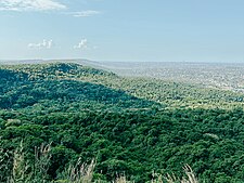
The Uluguru mountains are a mountain range in eastern Tanzania, named after the Luguru tribe. The main portion of the Uluguru mountains is a ridge running roughly north-south and rising to 2,630 metres (8,600 ft) altitude at its highest point. On the main Uluguru range, 50 villages touch the forest boundary and over 151,000 people are found within the mountain area, often at increasing densities at higher altitudes up to the forest boundary.
Mbudya Island is a protected, uninhabited island under the Dar es Salaam Marine Reserve with the IUCN category II located within Kinondoni District of Dar es Salaam Region in Tanzania. The island reserve measures around 14.2 km2. Fungu Yasin is to the north of the island, and Bongoyo Island is to the south. The island of Pangavini is to the west. The island is home to endangered coconunt crabs.
The Dar es Salaam pipistrelle is a species of vesper bat. It is found only in Dar es Salaam Region and Pwani Region of Tanzania. Its natural habitat is subtropical or tropical dry forests.

Hildegarde's tomb bat is a species of sac-winged bat in the family Emballonuridae. It is found near the coast in Kenya and Tanzania where it feeds in tropical dry forests and roosts in caves. It is a diurnal species and the International Union for Conservation of Nature has assessed its conservation status as "endangered". The specific name hildegardeae was given in honour of anthropologist Hildegarde Beatrice Hinde.

The Rondo dwarf galago or Rondo bushbaby is a species of primate in the family Galagidae. The dwarf galagos are the smallest members of the genus Galagoides. It weighs less than 100 grams, making it the smallest known galago. It is endemic to Tanzania where its natural habitat is subtropical or tropical dry forests. It lives in an area reported in 2012 to be less than 100 square kilometers and is threatened by habitat loss due to logging. While it was discovered in the 1950s, the Rondo dwarf galago was deemed data deficient until 1996. In 1996, the Rondo dwarf galago was fully described as a species. It is now listed as one of "The World's 25 Most Endangered Primates."
The Ulanga River, also known as the Kilombero River, rises in the highlands of the southwest of Morogoro Region, Tanzania, on the eastern slope of the East African Rift. The river flows northeast along the northeastern border of the Lindi Region before it flows into the Rufiji River. The Rufiji eventually flows into the Indian Ocean on the southern coast of the Pwani Region.
Kisarawe is a Tanzanian district that is the larger settlement of the Pugu Hills, southwest of Dar es Salaam. In the Kisarawe district there is an 8200-hectares cultivation of Jatropha shrubs that are processed to produce biodiesel.
The Kazimzumbwi Forest Reserve, officially listed as Pugu/Kazimzumbwi Nature Forest Reserve is a protected area located in Kisarawe ward of Kisarawe District in Pwani Region, Tanzania. It is located next to the Pugu ward of Ilala MC to the east, about 20 km (12 mi) south-west of Dar es Salaam. It covers an area of 4,887 hectares, at an altitude between 120 and 180 m. The reserve was established in 1936, but both agriculture and logging were tolerated for several years. Logging, in particular, went on until the 1970s.
Pugu is an administrative ward of the Ilala Municipical Council of the Dar es Salaam Region in Tanzania. Kinyerezi and Kwembe ward of Kinondoni MC form the ward's northern boundary. The ward is bordered by Majohe to the south and Gongolamboto to the east. In the west the ward is bordered by Kisarawe ward of Kisarawe District in the Pwani Region. The ward is named after the Pugu Hills, which form its western border and are home to the Pugu Hills Forest Reserve and the Kazimzumbwi Forest Reserve, two of some of the world's oldest forests. According to the 2012 census, the ward has a total population of 49,422.
The Church of Jesus Christ of Latter-day Saints in Tanzania refers to the Church of Jesus Christ of Latter-day Saints and its members in Tanzania. The first branch was organized in 1992. In 2021, there were 2,999 members in 23 congregations.
The Pande Game Reserve is a protected area located in Mabwepande ward of Kinondoni District and Mbezi ward of Ubungo District in Dar es Salaam Region of Tanzania that covers an area of 15.39 km2 (5.94 sq mi). It was established as a Forest Reserve in 1952 under the British colonial occupation.
The Vikindu Forest Reserve is a protected area located in Mkuranga District of Pwani Region in Tanzania that covers an area of 17.1 km2 (6.6 sq mi). Vikindu Forest Reserve is situated on a plain between 40 and 80 meters above sea level, about 15 kilometers inland from the Indian Ocean and about 17 kilometers south of Dar es Salaam on the main road to Kilwa. The main tarmac Dar es Salaam to Kilwa Road, which is part of the eastern edge of the forests reserve, provides access in all weather conditions. To the immediate south of the forest reserve is the village of Vikindu.
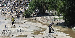
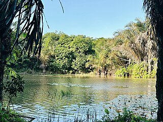
Msimbazi River is located in Dar es Salaam Region of Tanzania. It begins in Kisarawe ward, Kisarawe District and eventually drains into Zanzibar Channel at the border of Upanga West ward of Ilala MC and Hananasif ward of Kinondoni MC. The length of the Msimbazi River is about 35 kilometers. It flows eastward into the Zanzibar Channel of the Indian Ocean via the Pugu and Kazimzumbwi Forest Reserves, joining the Sinza, Ubungo, and Luhanga Rivers along the way.
Kwale Island is a protected, seasonally inhabited island in the Pemba Channel under the Tanga Marine Reserves (TMRS) with the IUCN category II located inside Kwale ward in Mkinga District of Tanga Region in Tanzania. The coral island, located approximately a kilometer offshore in Manza Bay, and the modern hamlet on the shoreline are both referred to as Kwale. 86.2% of Kwale Island, or 528.1 Ha, is covered with mangroves. Kwale Island and Ulenge Island are the only seasonally inhabited by islands in the marine reserve, thus the two have the most human impact. The Island has an average elevation of 7 m (23 ft).