The Great Barrier Reef is the world's largest coral reef system, composed of over 2,900 individual reefs and 900 islands stretching for over 2,300 kilometres (1,400 mi) over an area of approximately 344,400 square kilometres (133,000 sq mi). The reef is located in the Coral Sea, off the coast of Queensland, Australia, separated from the coast by a channel 160 kilometres (100 mi) wide in places and over 61 metres (200 ft) deep. The Great Barrier Reef can be seen from outer space and is the world's biggest single structure made by living organisms. This reef structure is composed of and built by billions of tiny organisms, known as coral polyps. It supports a wide diversity of life and was selected as a World Heritage Site in 1981. CNN labelled it one of the Seven Natural Wonders of the World in 1997. Australian World Heritage places included it in its list in 2007. The Queensland National Trust named it a state icon of Queensland in 2006.

The Great Barrier Reef Marine Park protects a large part of Australia's Great Barrier Reef from damaging activities. It is a vast multiple-use Marine Park which supports a wide range of uses, including commercial marine tourism, fishing, ports and shipping, recreation, scientific research and Indigenous traditional use. Fishing and the removal of artefacts or wildlife is strictly regulated, and commercial shipping traffic must stick to certain specific defined shipping routes that avoid the most sensitive areas of the park. The Great Barrier Reef is the largest and best known coral reef ecosystem in the world. Its reefs, almost 3000 in total, represent about 10 per cent of all the coral reef areas in the world. It supports an amazing variety of biodiversity, providing a home to thousands of coral and other invertebrate species, bony fish, sharks, rays, marine mammals, marine turtles, sea snakes, as well as algae and other marine plants.
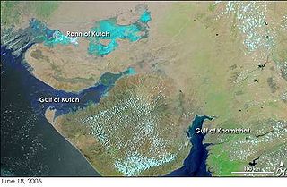
The Gulf of Kutch is located between the peninsula regions of Kutch and Saurashtra, bounded in the state of Gujarat that borders Pakistan. It opens towards the Arabian Sea facing the Gulf of Oman.

The Florida Keys National Marine Sanctuary is a U.S. National Marine Sanctuary in the Florida Keys. It includes the Florida Reef, the only barrier coral reef in North America and the third-largest coral barrier reef in the world. It also has extensive mangrove forest and seagrass fields. The Florida Keys National Marine Sanctuary, designated in 1990, is the ninth national marine sanctuary to be established in a system that comprises 13 sanctuaries and two marine national monuments. The Florida Keys National Marine Sanctuary protects approximately 2,900 square nautical miles of coastal and ocean waters from the estuarine waters of south Florida along the Florida Keys archipelago, encompassing more than 1,700 islands, out to the Dry Tortugas National Park, reaching into the Atlantic Ocean, Florida Bay and the Gulf of Mexico.

Southeast Asian coral reefs have the highest levels of biodiversity for the world's marine ecosystems. They serve many functions, such as forming the livelihood for subsistence fishermen and even function as jewelry and construction materials. Corals inhabit coastal waters off of every continent except Antarctica, with an abundance of reefs residing along Southeast Asian coastline in several countries including Indonesia, the Philippines, and Thailand. Coral reefs are developed by the carbonate-based skeletons of a variety of animals and algae. Slowly and over time, the reefs build up to the surface in oceans. Coral reefs are found in shallow, warm salt water. The sunlight filters through clear water and allows microscopic organisms to live and reproduce. Coral reefs are actually composed of tiny, fragile animals known as coral polyps. Coral reefs are significantly important because of the biodiversity. Although the number of fish are decreasing, the remaining coral reefs contain more unique sea creatures. The variety of species living on a coral reef is greater than anywhere else in the world. An estimation of 70-90% of fish caught are dependent on coral reefs in Southeast Asia and reefs support over 25% of all known marine species.
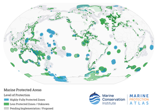
Marine protected areas (MPAs) are protected areas of the world's seas, oceans, estuaries or in the US, the Great Lakes. These marine areas can come in many forms ranging from wildlife refuges to research facilities. MPAs restrict human activity for a conservation purpose, typically to protect natural or cultural resources. Such marine resources are protected by local, state, territorial, native, regional, national, or international authorities and differ substantially among and between nations. This variation includes different limitations on development, fishing practices, fishing seasons and catch limits, moorings and bans on removing or disrupting marine life. In some situations, MPAs also provide revenue for countries, potentially equal to the income that they would have if they were to grant companies permissions to fish. The value of MPA to mobile species is unknown.
Cousin Island is a small granitic island of the Seychelles, lying 2 km (1.2 mi) west of Praslin. It is a nature reserve protected under Seychelles law as a Special Reserve. It is managed by Nature Seychelles, a national nonprofit organization and Partner of BirdLife International, by which it has been identified as an Important Bird Area.

The Ningaloo Coast is a World Heritage Site located in the north west coastal region of Western Australia. The 705,015-hectare (1,742,130-acre) heritage-listed area is located approximately 1,200 kilometres (750 mi) north of Perth, along the East Indian Ocean. The distinctive Ningaloo Reef that fringes the Ningaloo Coast is 260 kilometres (160 mi) long and is Australia's largest fringing coral reef and the only large reef positioned very close to a landmass. The Muiron Islands and Cape Farquhar are within this coastal zone.

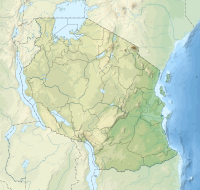
Chumbe Island is a private island in the Mjini Magharibi Region, Tanzania, off the coast of Mjini District. It is situated in the Zanzibar Channel. The island is known for its ecological innovation and exceptional coral reefs. The Chumbe Lighthouse is also located on the island.
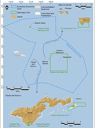
The National Marine Sanctuary of American Samoa is a federally-designated underwater area protected by the National Oceanic and Atmospheric Administration's (NOAA) Office of National Marine Sanctuaries. This sanctuary is the largest and most remote in the National Marine Sanctuary system. Spanning 13,581 sq mi, it is thought to be home to the greatest biodiversity of aquatic species of all the marine sanctuaries. Among them are expansive coral reefs, including some of the oldest Porites coral heads on earth, deep-water reefs, hydrothermal vent communities, and rare archeological resources. It was established in 1986, and then expanded and renamed in 2012.

Pescador Island is a small limestone island located in the Tañon Strait, a few kilometres from the western coast of the island of Cebu in the Philippines. It is under the jurisdiction of the municipality of Moalboal.

The Coral Triangle (CT) is a roughly triangular area in the tropical waters around the Philippines, Indonesia, Malaysia, Papua New Guinea, the Solomon Islands and Timor-Leste. This area contains at least 500 species of reef-building corals in each ecoregion. The Coral Triangle is located between the Pacific and Indian oceans and encompasses portions of two biogeographic regions: the Indonesian-Philippines Region, and the Far Southwestern Pacific Region. As one of eight major coral reef zones in the world, the Coral Triangle is recognized as a global centre of marine biodiversity and a global priority for conservation. Its biological resources make it a global hotspot of marine biodiversity. Known as the "Amazon of the seas", it covers 5.7 million square kilometres (2,200,000 sq mi) of ocean waters. It contains more than 76% of the world's shallow-water reef-building coral species, 37% of its reef fish species, 50% of its razor clam species, six out of seven of the world's sea turtle species, and the world's largest mangrove forest. In 2014, the Asian Development Bank (ADB) reported that the gross domestic product of the marine ecosystem in the Coral Triangle is roughly $1.2 trillion per year and provides food to over 120 million people. According to the Coral Triangle Knowledge Network, the region annually brings in about $3 billion in foreign exchange income from fisheries exports, and another $3 billion from coastal tourism revenues.
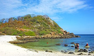
Pigeon Island National Park is one of the three marine national parks of Sri Lanka. The national park is situated 1 km off the coast of Nilaveli, a coastal town in Eastern Province, encompassing a total area of 471.429 hectares. The island's name derives from the rock pigeon which has colonized it. The national park contains some of the best remaining coral reefs of Sri Lanka. Pigeon Island was designated as a sanctuary in 1963. In 2003 it was re-designated as a national park, making it the 17th such park in Sri Lanka. The island was used as a shooting range during the colonial era. Pigeon Island was one of the several protected areas affected by the Indian Ocean tsunami in 2004.
Bacalar Chico National Park and Marine Reserve (BCNPMR) is a protected area and UNESCO World Heritage Site on the northern part of Ambergris Caye in Belize.
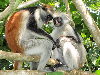
The wildlife of Zanzibar consists of terrestrial and marine flora and fauna in the archipelago of Zanzibar, an autonomous region of Tanzania. Its floral vegetation is categorized among the coastal forests of eastern Africa as the Southern Zanzibar-Inhambane coastal forest mosaic and the Northern Zanzibar-Inhambane coastal forest mosaic. Its faunal species are mostly small animals, birds, and butterflies.

The Menai Bay Conservation Area (MBCA) is located in Menai Bay, Zanzibar Tanzania. At 470 square kilometres (180 sq mi), it is Zanzibar's largest marine protected area. It was officially established as a conservation area in August 1997 in the traditional fishing area, known as Unguja Island, covering the tropical marine environment comprising extensive coral reefs, tropical fish, sea grasses, and mangrove forests. In addition to controlling illegal fishing, MBCA's alternative initiatives have included bee keeping, mangrove replanting, tree nurseries and tourism. The management of the MBCA falls upon the Fisheries Department and the bay's local villages. It is rated by the IUCN as Category VI Managed Resource Protected Area.

Angel Chua Alcala was a Filipino biologist who was named a National Scientist of the Philippines in 2014. Alcala is known for his fieldwork to build sanctuaries and to promote biodiversity in the aquatic ecosystems of the Philippines. He was the Chairman of the Board of Advisers at the Angelo King Center for Research and Environmental Management located in Silliman University. Alcala published more than 200 peer-reviewed articles and books and his biological contributions to the environment and ecosystems have made him a renowned figure of natural sciences in the Philippines.
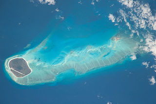
The Glorioso Islands Marine Natural Park is a marine park at the entrance of the Mozambique Channel, around the Glorioso Islands, in the Indian Ocean. It extends for more than 43,000 square kilometres (17,000 sq mi) until the edge of the French overseas territory's exclusive economic zone. Established in 2012, it is the fourth marine natural park created by France and the second in the Indian Ocean after Mayotte Marine Natural Park, which it abuts.
Chapwani Island is a private island located in Malindi ward of Mjini District in Mjini Magharibi Region, Tanzania. A British naval cemetery located in Chapwani serves as the last resting place for servicemen who died while serving in Zanzibar. These are the graves of those who perished in the attack by the German cruiser SMS Königsberg on the British protected cruiser HMS Pegasus during World War One. Interms of marine protection, Changuu and Chapwani reefs were seen as less protected, whereas Chumbe reefs and Kizimkazi reefs were thought to be well protected.
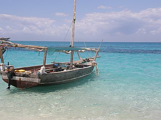
Kwale Island is a protected island located in Fumba ward of Mjini District in Mjini Magharibi Region, Tanzania. The island is included in the marine conservation area of Menai Bay.

