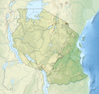
Mafia Island or Chole Shamba is an island of The Mafia Archipelago located in Mafia District in the southern Pwani Region of Tanzania across the Mafia Channel. The island is the third largest in Tanzanian ocean territory, but is not administratively included within the semi-autonomous region of Zanzibar, which has been politically separate since 1890. Mafia Island forms the largest part of Mafia District, one of the six administrative districts in the Pwani Region. As the Mafia Archipelago's main island, it's sometimes called Chole Shamba, meaning Chole farmlands in Swahili. This is in opposition to the historic settlement of Chole Mjini on Chole Island inside Mafia Bay. The island's population is over 65,000. The economy is based on fishing, subsistence agriculture and the market in Kilindoni. The island attracts some tourists, mainly scuba divers, birdwatchers, game fishermen, and people seeking relaxation.
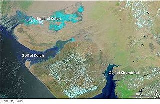
The Gulf of Kutch is located between the peninsula regions of Kutch and Saurashtra, bounded in the state of Gujarat that borders Pakistan. It opens towards the Arabian Sea facing the Gulf of Oman.

Blast fishing, fish bombing, dynamite fishing or grenade fishing is a destructive fishing practice using explosives to stun or kill schools of fish for easy collection. This often illegal practice is extremely destructive to the surrounding ecosystem, as the explosion often destroys the underlying habitat that supports the fish. The frequently improvised nature of the explosives used, and undetonated charges, means danger for fishermen and divers as well, with accidents and injuries.
Lady Elliot Island is the southernmost coral cay of the Great Barrier Reef, Australia. The island lies 46 nautical miles north-east of Bundaberg and covers an area of approximately 45 hectares. It is part of the Capricorn and Bunker Group of islands and is owned by the Commonwealth of Australia. The island is home to a small eco resort and an airstrip, which is serviced daily by flights from Bundaberg, Hervey Bay, Brisbane and the Gold Coast.

Apo Island is a volcanic island covering 74 hectares in land area, 7 kilometers off the southeastern tip of Negros Island and 30 kilometers south of the Negros Oriental capital of Dumaguete in the Philippines. The name "Apo" means "elder" or "respected ancestor" in the Visayan languages.

Pangavini Island is a protected, uninhabited island under the Dar es Salaam Marine Reserve with the IUCN category II located within Kinondoni District of Dar es Salaam Region in Tanzania. The island reserve measures around 2.13km2. Pangavini is the smallest island in the group, only about 250 m long; it has a rocky coastline without beaches. To the west of the island is Kunduchi ward and to the north is Mbudya Island. To the south of the island is Bongoyo Island.

Reef Check is an international non-governmental organization dedicated to the conservation of two reef ecosystems: tropical coral reefs and Californian rocky reefs. The Foundation is headquartered in Los Angeles, California, United States, but uses data from volunteer scuba diver teams in over 80 countries, ranging from Australia, Japan, to even Germany. It is the United Nations’ official coral reef monitoring program.

The Olango Island Group is a group of islands found in the Central Visayas region of the Philippines. It comprises Olango island and 6 satellite islets namely: Caubian, Camungi, Caohagan, Gilutongan, Nalusuan, Pangan-an, and Sulpa. The island group has a total land area of approximately 1,030 hectares. It is divided under the jurisdiction of the city of Lapu-Lapu and the municipality of Cordova, Cebu. It lies 5 kilometers (3.1 mi) east of Mactan and is a major tourist destination in Cebu. It is known for its wildlife sanctuary. The entire area is the first declared Ramsar Wetland Site in the Philippines, as recognized in 1994.

The Jozani Chwaka Bay National Park is a 50 km2 (19 sq mi) national park in Tanzania located on the island of Zanzibar. It is the only national park in Zanzibar.

Maziwe island officially, The Maziwe Island Marine Reserve Maziwe Marine Reserve is a small island located on the northern shores of Tanzania. One of the oldest marine reserves in Tanzania, this vibrant coral reef ecosystem supports over 400 species of fish as well as a stunning diversity of coral, sponge and algae species. Maziwe is also considered the most important breeding ground for turtles in East Africa. This coastal ecosystem is not only essential for its dependent wildlife but also for the long-term sustainability of the livelihoods of people living in the area.
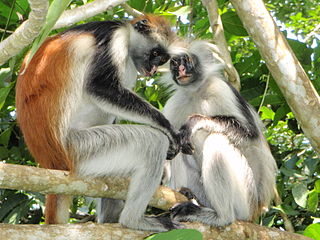
The wildlife of Zanzibar consists of terrestrial and marine flora and fauna in the archipelago of Zanzibar, an autonomous region of Tanzania. Its floral vegetation is categorized among the coastal forests of eastern Africa as the Southern Zanzibar-Inhambane coastal forest mosaic and the Northern Zanzibar-Inhambane coastal forest mosaic. Its faunal species are mostly small animals, birds, and butterflies.

The Chumbe Marine Park, officially recognized officially as Chumbe Reef Sanctuary is a privately managed marine park on Chumbe Island, Zanzibar since 1994. It is successful as an ecotourism project. The objective of this sanctuary is to preserve and develop the rich biodiversity of the coral. Set up after controversial debate over a period of 3 years between the private developer of the park, the government and the local fishermen, the sanctuary has received funds from European Union, Gesellschaft für Technische Zusammenarbeit and many other donors including the initial developer.

The Menai Bay Conservation Area (MBCA) is located in Menai Bay, Zanzibar Tanzania. At 470 square kilometres (180 sq mi), it is Zanzibar's largest marine protected area. It was officially established as a conservation area in August 1997 in the traditional fishing area, known as Unguja Island, covering the tropical marine environment comprising extensive coral reefs, tropical fish, sea grasses, and mangrove forests. In addition to controlling illegal fishing, MBCA's alternative initiatives have included bee keeping, mangrove replanting, tree nurseries and tourism. The management of the MBCA falls upon the Fisheries Department and the bay's local villages. It is rated by the IUCN as Category VI Managed Resource Protected Area.

Half Moon Caye is an island and natural monument of Belize located at the southeast corner of Lighthouse Reef Atoll. This natural monument was the first nature reserve to have been established in Belize under the National Park Systems Act in 1981 and first marine protected area in Central America. This is also Belize's oldest site of wildlife protection since it was first designated as a bird sanctuary in 1924 to protect the habitat of the red-footed booby birds.
The East African coral coast is a marine ecoregion along the eastern coast of Africa. It extends along the coasts of Kenya, Tanzania, and northern Mozambique, from Lamu in Kenya to Angoche in Mozambique. It adjoins the Northern Monsoon Current Coast ecoregion to the north, and the Bight of Sofala/Swamp Coast ecoregion to the south.
The Glorioso Islands Marine Natural Park is a marine park at the entrance of the Mozambique Channel, around the Glorioso Islands, in the Indian Ocean. It extends for more than 43,000 square kilometres (17,000 sq mi) until the edge of the French overseas territory's exclusive economic zone. Established in 2012, it is the fourth marine natural park created by France and the second in the Indian Ocean after Mayotte Marine Natural Park, which it abuts.
Chapwani Island is a private island located in Malindi ward of Mjini District in Mjini Magharibi Region, Tanzania. A British naval cemetery located in Chapwani serves as the last resting place for servicemen who died while serving in Zanzibar. These are the graves of those who perished in the attack by the German cruiser SMS Königsberg on the British protected cruiser HMS Pegasus during World War One. Interms of marine protection, Changuu and Chapwani reefs were seen as less protected, whereas Chumbe reefs and Kizimkazi reefs were thought to be well protected.
Kwale Island is a protected island located in Fumba ward of Mjini District in Mjini Magharibi Region, Tanzania. The island is included in the marine conservation area of Menai Bay.

Sume Island is a protected island located in Fumba ward of Mjini District in Mjini Magharibi Region, Tanzania. The island is included in the Menai Bay Marine Conservation Area. Sume reef protects on the biodiverse island. Field observations of Acropora spp. reefs on Sume Island in southern Zanzibar indicate that native Eucheuma denticulatum is flourishing there.

The La Cordillera Reef Nature Reserve, also known as the Reserva Natural Cayos de la Cordillera, is a nature reserve located 1.5 nautical miles off the coast of the barrio of Cabezas in the municipality of Fajardo in northeastern Puerto Rico. It consists of a small chain of cays, reefs, and islets, collectively known as La Cordillera or Cayos de la Cordillera. From west to east, the archipelago comprises Las Cucarachas islets, Los Farallones islets, Icacos cay, Ratones cay, Lobos cay, Palominos island, Palominitos island, La Blanquilla cay and islets, Diablo cay, Hermanos reefs, and Barriles reefs. The nature reserve covers about 18 nautical miles and almost 30,000 acres between cape Las Cabezas de San Juan in Cabezas, Fajardo and the Spanish virgin island of Culebra.