Kinondoni District, officially the Kinondoni Municipal Council is one of five districts of the Dar es Salaam Region of Tanzania. The district is bordered to the north by Bagamoyo District and Kibaha of Pwani Region, to the east by the Indian Ocean, the west by Ubungo District, and to the south by the Ilala District. The district covers an area of 269.5 km2 (104.1 sq mi). The district is comparable in size to the land area of Malta. The administrative seat is Ndugumbi. The district is home to one of the best preserved Medieval Swahili settlements, Kunduchi Ruins, headquarters for the National Muslim Council of Tanzania (BAKWATA) and Makumbusho Village Museum. Considered the cultural center of Dar es Salaam, Kinondoni District is also regarded the birthplace of the musical genre of Singeli. In addition the district is one of two districts in Dar es Salaam that has a National Historic Site, namely the Kunduchi Ruins.The 2012 National Tanzania Census states the population for Kinondoni as 1,775,049.

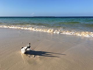
The intertidal zone or foreshore is the area above water level at low tide and underwater at high tide: in other words, the part of the littoral zone within the tidal range. This area can include several types of habitats with various species of life, such as seastars, sea urchins, and many species of coral with regional differences in biodiversity. Sometimes it is referred to as the littoral zone or seashore, although those can be defined as a wider region.
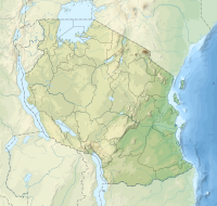
Bongoyo Island is a protected, uninhabited island under the Dar es Salaam Marine Reserve with the IUCN category II located within Kinondoni District of Dar es Salaam Region in Tanzania. The island situated 2.5 km north of the country's largest city, Dar es Salaam in the Sea of Zanj. It is the most frequently visited of the four islands of the Dar es Salaam Marine Reserve System (DMRS) and a popular daytrip for both tourists and Tanzanian residents alike for snorkelling and sunbathing. North of the island is Mbudya Island and to the west is Pangavini Island. The island is home to some of Tanzania's largest specimens of endangered coconut crabs.
Mbudya Island is a protected, uninhabited island under the Dar es Salaam Marine Reserve with the IUCN category II located within Kinondoni District of Dar es Salaam Region in Tanzania. The island reserve measures around 14.2 km2. Fungu Yasin is to the north of the island, and Bongoyo Island is to the south. The island of Pangavini is to the west. The island is home to endangered coconunt crabs.
The Dar es Salaam Marine Reserve System or DMRS is a group of marine reserves in Tanzania, with the IUCN category II located within Dar es Salaam Region of Tanzania. The reserve system consists of nine uninhabited islands, four located north of Dar es Salaam's Kinondoni District; and four south of the city Makatumbi Islands, Kimbubu Island, Sinda Island and Kendwa Island in Kigamboni District. It provides protection for several important tropical ecosystems; coral reefs, mangroves and seagrass beds.

Pangavini Island is a protected, uninhabited island under the Dar es Salaam Marine Reserve with the IUCN category II located within Kinondoni District of Dar es Salaam Region in Tanzania. The island reserve measures around 2.13km2. Pangavini is the smallest island in the group, only about 250 m long; it has a rocky coastline without beaches. To the west of the island is Kunduchi ward and to the north is Mbudya Island. To the south of the island is Bongoyo Island.

Apo Reef is a coral reef system in the Philippines situated in the western waters of Occidental Mindoro province in the Mindoro Strait. Encompassing 34 square kilometres (13 sq mi), it is considered the world's second-largest contiguous coral reef system, and is the largest in the country. The reef and its surrounding waters are protected areas administered as the Apo Reef Natural Park (ARNP). It is one of the best known and most popular diving regions in the country, and is in the tentative list for UNESCO World Heritage Sites.

Maziwi island officially, The Maziwe Island Marine Reserve is a unvegetated, protected island surrounded by coral reefs located about 8 kilometres (5.0 mi) south east of the town of Pangani off the northern coast of Tanga Region in Tanzania. The island is administered under Mwera ward of Pangani District. However, it is currently under the Tanga Marine Reserves System. It became a nature reserve in 1975. At one time the island was larger than its present area and was well-vegetated but with the loss of its coconut trees and scrub cover, it has suffered erosion and is now sometimes completely immersed at the time of the highest tides. Green sea turtles no longer nest on the island, but it is visited by numerous sea birds. The sea contains many species of coral and over two hundred species of fish. The reserve has received little active conservation work but management is now supported by levying a small fee on tourists which is used to compensate local fishermen for loss of income.

A marine habitat is a habitat that supports marine life. Marine life depends in some way on the saltwater that is in the sea. A habitat is an ecological or environmental area inhabited by one or more living species. The marine environment supports many kinds of these habitats.
Phyllodesmium pecten is a species of sea slug, an aeolid nudibranch, a marine gastropod mollusc in the family Facelinidae.

Solitary Islands Marine Park (SIMP) is a marine park in New South Wales State waters, Australia. It adjoins the Solitary Islands Marine Reserve and was declared under the Marine Parks Act 1997 (NSW) in January 1998. Prior to this it was declared a marine reserve in 1991. The Park was one of the first declared in NSW and stretches along the northern NSW coast, from Muttonbird Island, Coffs Harbour, to Plover Island near Sandon River, 75 kilometres to the north. It includes coastal estuaries and lakes and extends from the mean high water mark, to three nautical miles out to sea, covering an area of around 72 000 hectares. There are five main islands in the Park, North Solitary Island, North West Solitary Island, South West Solitary Island, South Solitary Island and Split Solitary Island, as well as other significant outcrops such as Muttonbird Island and submerged reefs.
The East African coral coast is a marine ecoregion along the eastern coast of Africa. It extends along the coasts of Kenya, Tanzania, and northern Mozambique, from Lamu in Kenya to Angoche in Mozambique. It adjoins the Northern Monsoon Current Coast ecoregion to the north, and the Bight of Sofala/Swamp Coast ecoregion to the south.
Kwale Island is a protected, seasonally inhabited island in the Pemba Channel under the Tanga Marine Reserves (TMRS) with the IUCN category II located inside Kwale ward in Mkinga District of Tanga Region in Tanzania. The coral island, located approximately a kilometer offshore in Manza Bay, and the modern hamlet on the shoreline are both referred to as Kwale. 86.2% of Kwale Island, or 528.1 Ha, is covered with mangroves. Kwale Island and Ulenge Island are the only seasonally inhabited by islands in the marine reserve, thus the two have the most human impact. The Island has an average elevation of 7 m (23 ft).
Makatumbi Islands or Makatumbe Islands are a protected, uninhabited islands in the Sea of Zanj under the Dar es Salaam Marine Reserve (DMRS) with the IUCN category II located within Kigamboni District of Dar es Salaam Region in Tanzania. The islands reserve measures around 7.8km2 consisting of inner and outer Makatumbi Island. South of the island is Kimbubu Island and north is the Dar es Salaam harbor mouth. The island is under threat from Marine pollution as elevated cadmium readings offshore for a core found east of Makatumbe Island near the entrance to the Dar es Salaam harbour.

Sinda Island is a protected, uninhabited island in the Sea of Zanj under the Dar es Salaam Marine Reserve (DMRS) with the IUCN category II located within Kigamboni District of Dar es Salaam Region in Tanzania. The islands reserve measures around 4.6km2 consisting of inner and outer Sinder Island. South of the island is Kikwero reef and west is the Somangila ward of Kigamboni. The island is home to endangered coconunt crabs. The Islands are home to ruins that date back to the 19th century, but Arab sailor Ibn Majid first noted the islands in 1470.
Kimbubu Island is a protected, uninhabited island in the Sea of Zanj under the Dar es Salaam Marine Reserve (DMRS) with the IUCN category II located within Kigamboni District of Dar es Salaam Region in Tanzania. The islands reserve measures around 4.7km2. East of the island is Sinda Island, north is the Makatumbi Islands and west is the Mjimwema ward of Kigamboni.
Kendwa Island is a protected, uninhabited island in the Sea of Zanj under the Dar es Salaam Marine Reserve (DMRS) with the IUCN category II located within Kigamboni District of Dar es Salaam Region in Tanzania. The islands reserve measures around 5.30km2. The Sinda Island is to the east of the island, the Makatumbi Islands are to the north, and the Kigamboni ward of Kigamboni is to the west. The island is home to endangered coconunt crabs.
Kirui Island officially, Kirui Island Marine Reserve is a protected, uninhabited island in the Pemba Channel under the Tanga Marine Reserves (TMRS) with the IUCN category II located within Mkinga District of Tanga Region in Tanzania. The Island is the largest in Tanga and one of the largest protected marine Islands in Tanzania Mangroves are thought to cover 680 ha (ha) of the island of Kirui, with the largest mangrove area being on the north and west sides, Kigomeni mangrove being on the east coast, and Kirui South Mangrove being on the south.
Mwewe Island officially, Mwewe Island Marine Reserve is a protected, uninhabited island in the Pemba Channel under the Tanga Marine Reserves (TMRS) with the IUCN category II located within Mkinga District of Tanga Region in Tanzania. Acoording to oral Digo history, the island was used by some Kirui Island residents, Mwewe Island was eventually purchased by Sultan Bin Athmani of Moa.
Ulenge Island officially, Ulenge Island Marine Reserve is a protected, seasonally habited island in the Tanga Bay of Pemba Channel under the Tanga Marine Reserves (TMRS) with the IUCN category II located within Tanga City Council of Tanga Region in Tanzania. Kwale Island and Ulenge Island are the only islands in the marine reserve that are seasonally inhabited. Of Tanga's whole marine reserves system, Ulenge Island is the most degraded. Ulenge's reefs had the lowest fish numbers and the lowest coral cover and species diversity. This is mostly because Tanga Bay and Tanga City Council are nearby, which has a greater negative human impact. Ulenge Island is nicknamed by English speakers as Bird Island due to its importance as a seabird sanctuary.