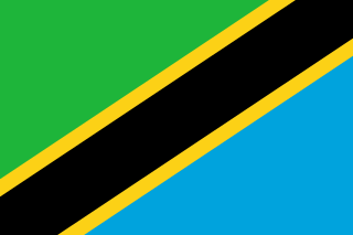
Tanzania, officially the United Republic of Tanzania, is a country in East Africa within the African Great Lakes region. It is bordered by Uganda to the northwest; Kenya to the northeast; the Indian Ocean to the east; Mozambique and Malawi to the south; Zambia to the southwest; and Rwanda, Burundi, and the Democratic Republic of the Congo to the west. Mount Kilimanjaro, Africa's highest mountain, is in northeastern Tanzania. According to the 2022 national census, Tanzania has a population of nearly 62 million, making it the most populous country located entirely south of the equator.

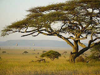
The Serengeti National Park is a large national park in northern Tanzania that stretches over 14,763 km2 (5,700 sq mi). It is located in eastern Mara Region and northeastern Simiyu Region and contains over 1,500,000 hectares of virgin savanna. The park was established in 1940.

Mtwara Region is one of Tanzania's 31 administrative regions. The regional capital is the municipality of Mtwara. Mtwara Region is home to one of the most infuluencial people in Tanzania, the Makonde. Mtwara is home to Tanzania's 4th president Benjamin Mkapa and is home to a number of influential artists. The boundary with Mozambique to the south is formed by the Ruvuma River. To the west, Mtwara is bordered by Ruvuma Region, to the north by Lindi Region, and to the east is the Indian Ocean.

Kilwa District is one of six administrative districts of Lindi Region in Tanzania. The District covers an area of 15,000 km2 (5,800 sq mi). The district is comparable in size to the land area of the nation state of East Timor. Kilwa district is bordered to the north by Rufiji District in Pwani Region, to the east by the Indian Ocean, to the south by the Lindi District, Nachingwea District together with Ruangwa District, and to the west by the Liwale District. The district borders every other district in Lindi Region except Lindi Municipal District. The district seat (capital) is the town of Kilwa Masoko. The district is named after the medieval Swahili city state of Kilwa Kisiwani. According to the 2012 census, the district has a total population of 190,744. By 2022, the population had increased to 297,676.

Mara Region is one of Tanzania's 31 administrative regions. The region covers an area of 21,760 km2 (8,400 sq mi). The region is comparable in size to the combined land area of the nation state of El Salvador. The neighboring regions are Mwanza Region and Simiyu Region, Arusha Region, and Kagera Region. The Mara Region borders Kenya .The regional capital is the municipality of Musoma. Mara Region is known for being the home of Serengeti National Park, a UNESCO World Heritage site and also the birth place of Tanzania's founding father Julius Nyerere. Under British colonial occupation, the Mara Region was a district called the Lake Province, which became the Lake Region after independence in 1961.

Arusha Region is one of Tanzania's 31 administrative regions and is located in the northeast of the country. The region's capital and largest city is the city of Arusha. The region is bordered by Kajiado County and Narok County in Kenya to the north, the Kilimanjaro Region to the east, the Manyara and Singida Regions to the south, and the Mara and Simiyu regions to the west. Arusha Region is home to Ngorongoro Conservation Area, a UNESCO World Heritage Site. The region is comparable in size to the combined land and water areas of the state of Maryland in the United States.

Kigoma Region is one of Tanzania's 31 administrative regions. The regional capital is the city of Kigoma. Kigoma Region borders Kagera Region, Geita Region, Katavi Region, Tabora Region, DRC and Burundi According to the 2012 national census, the region had a population of 2,127,930, which was higher than the pre-census projection of 1,971,332. For 2002–2012, the region's 2.4 percent average annual population growth rate was tied for the fourteenth highest in the country. It was also the sixteenth most densely populated region with 57 people per square kilometer. With a size of 45,066 square kilometres (17,400 sq mi), the region is slightly smaller than Estonia.

Tabora Region is one of Tanzania's 31 administrative regions. The regional capital is the municipality of Tabora. The region is located in mid-western part of Tanzania. Tabora is bordered by Shinyanga to the north, Singida to the east, Mbeya and Songwe to the south. lastly, Katavi, Kigoma and Geita, border Tabora to the west. Tabora is by far the largest region in Tanzania by area. Most of the population in the region is concentrated in the north in Nzega district. According to the 2022 national census, Tabora Region had a population of 3,391,679.

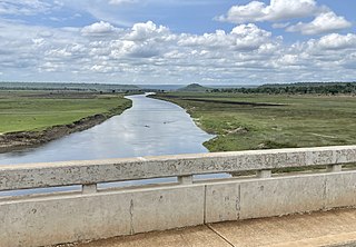
The Malagarasi River is a river in western Tanzania, flowing through Kigoma Region, although one of its tributaries comes from southeastern Burundi. The river also forms the western border of Tabora Region, the southern border of Kagera Region and the southwestern border of Geita Region. It is the second-longest river in Tanzania behind the Rufiji—Great Ruaha, and has the largest watershed of any river flowing into Lake Tanganyika. The Malagarasi-Muyovozi Wetlands are a designated a Ramsar site. Local tribes have nicknamed the Malagarasi as "the river of bad spirits".

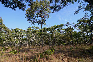
The Central Zambezian miombo woodlands ecoregion spans southern central Africa. Miombo woodland is the predominant plant community. It is one of the largest ecoregions on the continent, and home to a great variety of wildlife, including many large mammals.
The Kigosi National Park (Hifadhi ya Taifa ya Kigosi, In Swahili) is a national park located in Shinyanga Region, Geita Region and northwest Tabora Region of Tanzania. In 2019, Kigosi National Park was created. Kigosi National Park was established in 2019. It is a part of the Moyowosi/Malagarasi wetlands complex, which is the largest wetlands complex in East Africa, and has an area of 8,265 km2. The Malagarasi, Moyowosi, Nikonga, Ugalla, Kigosi, Nikonga, and Gombe are seven slow-moving rivers that meander through a vast and intricate network of marshes, plains lakes, and woodlands. These rivers should not be confused with the Gombe Stream National Park where the chimpanzees live. These rivers eventually combine to form the Malagarasi River, which empties into Ilagala's Lake Tanganyika. With a total area of almost 92,000 square kilometers, the wetland system is larger than the entire country of Portugal.

Tanzania contains some 20 percent of the species of Africa's large mammal population, found across its reserves, conservation areas, marine parks, and 17 national parks, spread over an area of more than 42,000 square kilometres (16,000 sq mi) and forming approximately 38 percent of the country's territory. Wildlife resources of Tanzania are described as "without parallel in Africa" and "the prime game viewing country". Serengeti National Park, the country's second largest national park area at 14,763 square kilometres (5,700 sq mi), is located in northern Tanzania and is famous for its extensive migratory herds of wildebeests and zebra while also having the reputation as one of the great natural wonders of the world. The Ngorongoro Conservation Area, established in 1959, is a UNESCO World Heritage Site and inhabited by the Maasai people. Its Ngorongoro Crater is the largest intact caldera in the world.

Katavi Region is one of Tanzania's 31 administrative regions. The region covers an area of 45,843 km2 (17,700 sq mi). The region is comparable in size to the combined land area of the nation state of Estonia. Katavi Region is bordered to the east by Tabora Region. The region is bordered to the south by Rukwa Region and Songwe Region. Lastly, Katavi borders DRC on Lake Tanganyika to the west. The region derives its name from Katavi, the spirit of lake Tanganyika. The regional capital city is Mpanda. According to the 2022 national census, the region had a population of 1,152,958.
The Tanzania National Parks Authority commonly known as TANAPA is responsible for the management of Tanzania's national parks. TANAPA is a parastatal corporation and all its income is reinvested into the organization. It is governed by a number of instruments including the National Parks Act, Chapter 282 of the 2002 and the Wildlife Conservation Act No. 5 of 2009. TANAPA manages the nation's 23 National parks which covers approximately 15% of the land area and has the mandate to conserve and manage the wildlife in Tanzania, and to enforce the related laws and regulations in this industry. It manages the biodiversity of the country, protecting and conserving the flora and fauna. The organization does not have a mandate over the game reserves such as the Selous Game Reserve which is managed by the Tanzanian Wildlife Division and the Ngorongoro Conservation Area managed by the Ngorongoro Conservation Authority.

3°48′43″S35°53′20″E — River mouth
The Ufipa Plateau is a highland in southwestern Tanzania. It lies mostly in Rukwa Region, near the border with Zambia. The plateau is named for the Fipa people who inhabit it.

Nyerere National Park is the largest national park in Tanzania and also one of the world's largest wildlife sanctuaries and national parks. The total area of the park is 30,893 km2 (11,928 sq mi) and covers the big part of Liwale District in western Lindi Region, south west Pwani Region, north eastern Ruvuma Region and a big part of south eastern Morogoro Region. The park is about the size of Belgium (Europe). Much of the area is in a wild state without being altered by human activities. The part of Selous game reserve is now running a hydro electric power. The park has a great river known as Rufiji River. Rufiji is Tanzania's largest river and is home to many crocodiles and hippopotamuses. It is also one of largest mangrove forests in the world located at its delta.

Itigi District is a district council in the Singida Region of central Tanzania established in 2015. The district lies in the south-western portion of the Singida Region with 279,069 people and encompasses a large area mostly made up of protected game reserves.

Nsimbo District is a district council in the Katavi Region of Tanzania's Southern Highlands established in 2012. The district lies in the middle of the region east of the city of Mpanda. It is a tropical environment of mostly forest reserves and agricultural economy.


