
The Comoro Islands or the Comoros are an archipelago of volcanic islands situated off the southeastern coast of Africa, to the east of Mozambique and northwest of Madagascar. The islands are politically divided between the Union of the Comoros, a sovereign country, and Mayotte, an Overseas Department of France.

The Mnazi Bay-Ruvuma Estuary Marine Park(MBREMP) was established on 1 July 2000 under Act No. 29 of 1994 of Marine Parks and Reserves of Tanzania.

Hol Chan Marine Reserve is a marine reserve close to Ambergris Caye and Caye Caulker, off the coast of Belize. It covers approximately 18 km² (4,448 acres) of coral reefs, seagrass beds, and mangrove forest. Hol Chan is Mayan for "little channel".

Sodwana Bay is a bay in South Africa on the KwaZulu Natal north coast, between St. Lucia and Lake Sibhayi. It is in the Sodwana Bay National Park, and the Maputaland Marine Reserve, and is a popular recreational diving destination. The term is commonly used to refer to both the marine reserve and the terrestrial park, as well as the geographical bay.
The Dar es Salaam Marine Reserve System or DMRS is a group of marine reserves in Tanzania, with the IUCN category II located within Dar es Salaam Region of Tanzania. The reserve system consists of nine uninhabited islands, four located north of Dar es Salaam's Kinondoni District; and four south of the city Makatumbi Islands, Kimbubu Island, Sinda Island and Kendwa Island in Kigamboni District. It provides protection for several important tropical ecosystems; coral reefs, mangroves and seagrass beds.

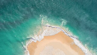
Maziwi island officially, The Maziwe Island Marine Reserve is a unvegetated, protected island surrounded by coral reefs located about 8 kilometres (5.0 mi) south east of the town of Pangani off the northern coast of Tanga Region in Tanzania. The island is administered under Mwera ward of Pangani District. However, it is currently under the Tanga Marine Reserves System. It became a nature reserve in 1975. At one time the island was larger than its present area and was well-vegetated but with the loss of its coconut trees and scrub cover, it has suffered erosion and is now sometimes completely immersed at the time of the highest tides. Green sea turtles no longer nest on the island, but it is visited by numerous sea birds. The sea contains many species of coral and over two hundred species of fish. The reserve has received little active conservation work but management is now supported by levying a small fee on tourists which is used to compensate local fishermen for loss of income.

The East African mangroves are a mangrove ecoregion consisting of swamps along the Indian Ocean coast of East Africa in Mozambique, Tanzania, Kenya and southern Somalia.
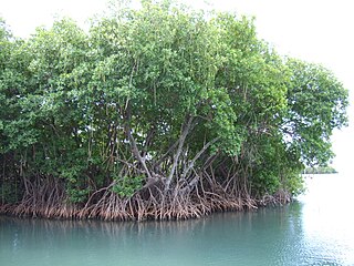
Mangrove ecosystems represent natural capital capable of producing a wide range of goods and services for coastal environments and communities and society as a whole. Some of these outputs, such as timber, are freely exchanged in formal markets. Value is determined in these markets through exchange and quantified in terms of price. Mangroves are important for aquatic life and home for many species of fish.
The Guiuan Protected Landscape and Seascape, also known as the Guiuan Marine Reserve, is a protected area associated with the Guiuan Island Group which is located off the coast of the municipality of Guiuan on the eastern side of Leyte Gulf in the Philippines. The protected area consists of the following islands from within the group: Calicoan, Manicani, Suluan, Tubabao, Victory, Homonhon and other smaller islands and their surrounding reefs. It also includes the coastal area of mainland Guiuan in Eastern Samar covering a total area of 60,448 hectares. The land which now comprises the conservation area was previously declared as a Marine Reserve and Tourist Zone and was placed under the administration and control of the Philippine Tourism Authority in 1978. It was re-proclaimed and re-classified as a protected landscape/seascape in 1994 under the National Integrated Protected Areas System Act of 1992.
The St. Croix East End Marine Park (STXEEMP) was established to "protect territorially significant marine resources, and promote sustainability of marine ecosystems, including coral reefs, sea grass beds, wildlife habitats and other resources, and to conserve and preserve significant natural areas for the use and benefit of future generations." It is the U.S. Virgin Islands’ first territorially designated and managed marine protected area (MPA).
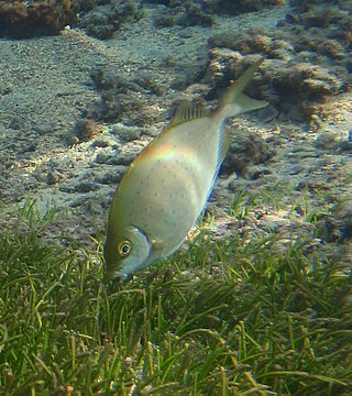
Siganus sutor, the shoemaker spinefoot rabbitfish ,whitespotted rabbitfish or African whitespotted rabbitfish, is a species of marine ray-finned fish, a rabbitfish belonging to the family Siganidae. It lives in Indo-Pacific coral reefs. It is endemic to the Indian Ocean, from Indonesia to Comoros. S. sutor is one of the commercial marine fishes, which is ubiquitously caught, in Tanzania and the entire East African coast of Indian ocean. S. sutor is among the most common fish species in the marine fisheries of Kenya, and accounts for around 40% of the artisanal fishery landings. Various fishing gears are used to target the siganids, but basket traps are the preferred ones. It is one of the mangrove/seagrass-associated coral reef fishes. This species inhabits littoral areas and its fin spines are venomous to humans.

The Bonaire National Marine Park or BNMP is one of the oldest marine reserves in the world. It includes the sea around Bonaire and Klein Bonaire from the high water line to a depth of sixty meters. The park was established in 1979 and covers 2700 hectares and includes a coral reef, seagrass, and mangrove vegetation. The Lac Bay lagoon is also part of the underwater park.
The East African coral coast is a marine ecoregion along the eastern coast of Africa. It extends along the coasts of Kenya, Tanzania, and northern Mozambique, from Lamu in Kenya to Angoche in Mozambique. It adjoins the Northern Monsoon Current Coast ecoregion to the north, and the Bight of Sofala/Swamp Coast ecoregion to the south.
The Northern Monsoon Current coast is a marine ecoregion along the eastern coast of Africa. It extends along a portion of the coasts of Somalia and Kenya, from south of Lamu in Kenya to north of Mogadishu in Somalia. It adjoins the Central Somali coast ecoregion to the north, and the East African coral coast ecoregion to the south.
The Tanga Coelacanth Marine Park (TCMP) is a Marine park in Tanzania, with the IUCN category II located within Tanga Region of Tanzania. The Tanga Coelacanth Marine Park (TACMP), which covers the entirety of Tanga City and all Coastal Areas from Tanga Bay and South of the Fishing Village of Kigombe, was Gazetted in 2009 by the Government of Tanzania (GoT) in recognition of the value of the Coelacanths and for their protection. Coelacanths have been spotted on Tanga Island, Mwambani Bay, Yambe Island, and Karange Island, all of which are part of the Park.
Kwale Island is a protected, seasonally inhabited island in the Pemba Channel under the Tanga Marine Reserves (TMRS) with the IUCN category II located inside Kwale ward inMkinga District of Tanga Region in Tanzania. The coral island, located approximately a kilometer offshore in Manza Bay, and the modern hamlet on the shoreline are both referred to as Kwale. 86.2% of Kwale Island, or 528.1 Ha, is covered with mangroves. Kwale Island and Ulenge Island are the only seasonally inhabited by islands in the marine reserve, thus the two have the most human impact. The Island has an average elevation of 7 m (23 ft).
Kirui Island officially, Kirui Island Marine Reserve is a protected, uninhabited island in the Pemba Channel under the Tanga Marine Reserves (TMRS) with the IUCN category II located within Mkinga District of Tanga Region in Tanzania. The Island is the largest in Tanga and one of the largest protected marine Islands in Tanzania Mangroves are thought to cover 680 ha (ha) of the island of Kirui, with the largest mangrove area being on the north and west sides, Kigomeni mangrove being on the east coast, and Kirui South Mangrove being on the south.
Mwewe Island officially, Mwewe Island Marine Reserve is a protected, uninhabited island in the Pemba Channel under the Tanga Marine Reserves (TMRS) with the IUCN category II located within Mkinga District of Tanga Region in Tanzania. Acoording to oral Digo history, the island was used by some Kirui Island residents, Mwewe Island was eventually purchased by Sultan Bin Athmani of Moa.
Ulenge Island officially, Ulenge Island Marine Reserve is a protected, seasonally habited island in the Tanga Bay of Pemba Channel under the Tanga Marine Reserves (TMRS) with the IUCN category II located within Tanga City Council of Tanga Region in Tanzania. Kwale Island and Ulenge Island are the only islands in the marine reserve that are seasonally inhabited. Of Tanga's whole marine reserves system, Ulenge Island is the most degraded. Ulenge's reefs had the lowest fish numbers and the lowest coral cover and species diversity. This is mostly because Tanga Bay and Tanga City Council are nearby, which has a greater negative human impact. Ulenge Island is nicknamed by English speakers as Bird Island due to its importance as a seabird sanctuary.
