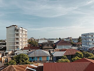
Tanga is a historic city and the capital of Tanga Region. The city is the most northernly port city of Tanzania to the west of the Indian Ocean on Tanga Bay. The city has a population of 393,429 in 2022. Tanga is governed by the Tanga City Council. The city is also home to the Port of Tanga. The name Tanga means "sail" in Swahili. The city is also the capital of Tanga District.

Latimeria is a rare genus of fish which contains the only living species of coelacanth. It includes two extant species: the West Indian Ocean coelacanth and the Indonesian coelacanth. They follow the oldest known living lineage of Sarcopterygii, which means they are more closely related to lungfish and tetrapods than to the common ray-finned fishes and cartilaginous fishes.

Blast fishing, fish bombing, dynamite fishing or grenade fishing is a destructive fishing practice using explosives to stun or kill schools of fish for easy collection. This often illegal practice is extremely destructive to the surrounding ecosystem, as the explosion often destroys the underlying habitat that supports the fish. The frequently improvised nature of the explosives used, and undetonated charges, means danger for fishermen and divers as well, with accidents and injuries.

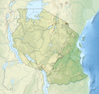
Tanga Region is one of Tanzania's 31 administrative regions. The region covers an area of 26,667 km2 (10,296 sq mi). The region is comparable in size to the combined land area of the nation state of Burundi. The regional capital is the municipality of Tanga city. Located in northeast Tanzania, the region is bordered by Kenya and Kilimanjaro Region to the north; Manyara Region to the west; and Morogoro and Pwani Regions to the south. It has a coastline to the east with the Indian Ocean. According to the 2012 national census, the region had a population of 2,045,205.

Tanga Island known during German East Africa as Toten Island in old colonial maps

Mafia Island Marine Park is a protected marine park with the IUCN category VI around the Mafia Archipelago in the Indian Ocean's sea of Zanj. It is administratively located in the jurisdiction Mafia District of Pwani Region in Tanzania.

Maziwi island officially, The Maziwe Island Marine Reserve is a unvegetated, protected island surrounded by coral reefs located about 8 kilometres (5.0 mi) south east of the town of Pangani off the northern coast of Tanga Region in Tanzania. The island is administered under Mwera ward of Pangani District. However, it is currently under the Tanga Marine Reserves System. It became a nature reserve in 1975. At one time the island was larger than its present area and was well-vegetated but with the loss of its coconut trees and scrub cover, it has suffered erosion and is now sometimes completely immersed at the time of the highest tides. Green sea turtles no longer nest on the island, but it is visited by numerous sea birds. The sea contains many species of coral and over two hundred species of fish. The reserve has received little active conservation work but management is now supported by levying a small fee on tourists which is used to compensate local fishermen for loss of income.

The Ulenge Island Rear Range Lighthouse is a historic lighthouse on Ulenge Island in the Pemba Channel under the Tanga Marine Reserves (TMRS) with the IUCN category II located within Tanga City Council of Tanga Region in Tanzania.
The Ulenge Island Front Range Lighthouse is a historic lighthouse on Ulenge Island in the Pemba Channel under the Tanga Marine Reserves (TMRS) with the IUCN category II located within Tanga City Council of Tanga Region in Tanzania.

The Marine Park and Reserves Unit of Tanzania was formed in 1994 under the Marine Parks and Reserve Act No 29, of 1994. The headquarters are located in Upanga West ward of Ilala District in Dar es Salaam Region. Previously all marine life and biodiversity was under the Ministry of Livestock and Fisheries. The population along the 1400 km Tanzanian coastline has reached to over 10 million and the increase in number of people whose livelihood depends on the marine resource has also increased. The increase in population has caused various threats to the marine life due to over fishing, coral mining and unplanned increase in settlements. To protect the marine biodiversity the Government of Tanzania established the Marine Park and Reserves unit in 1994 with Mafia Island Marine Park as the first marine park.
The East African coral coast is a marine ecoregion along the eastern coast of Africa. It extends along the coasts of Kenya, Tanzania, and northern Mozambique, from Lamu in Kenya to Angoche in Mozambique. It adjoins the Northern Monsoon Current Coast ecoregion to the north, and the Bight of Sofala/Swamp Coast ecoregion to the south.
The Tanga Coelacanth Marine Park (TCMP) is a Marine park in Tanzania, with the IUCN category II located within Tanga Region of Tanzania. The Tanga Coelacanth Marine Park (TACMP), which covers the entirety of Tanga City and all Coastal Areas from Tanga Bay and South of the Fishing Village of Kigombe, was Gazetted in 2009 by the Government of Tanzania (GoT) in recognition of the value of the Coelacanths and for their protection. Coelacanths have been spotted on Tanga Island, Mwambani Bay, Yambe Island, and Karange Island, all of which are part of the Park.
Yambe Island is protected, uninhabited historic island located directly east of the city of Tanga in Tanga District of Tanga Region in Tanzania. It is the largest island in Tanga region. It is located entirely with the Tanga Coelacanth Marine Park (TCMP). The island is administered by Tanzania Marine Parks and Reserves. The island is also home to medieval Swahili ruins that have yet to be excavated.
Kwale Island is a protected, seasonally inhabited island in the Pemba Channel under the Tanga Marine Reserves (TMRS) with the IUCN category II located inside Kwale ward inMkinga District of Tanga Region in Tanzania. The coral island, located approximately a kilometer offshore in Manza Bay, and the modern hamlet on the shoreline are both referred to as Kwale. 86.2% of Kwale Island, or 528.1 Ha, is covered with mangroves. Kwale Island and Ulenge Island are the only seasonally inhabited by islands in the marine reserve, thus the two have the most human impact. The Island has an average elevation of 7 m (23 ft).
Kirui Island officially, Kirui Island Marine Reserve is a protected, uninhabited island in the Pemba Channel under the Tanga Marine Reserves (TMRS) with the IUCN category II located within Mkinga District of Tanga Region in Tanzania. The Island is the largest in Tanga and one of the largest protected marine Islands in Tanzania Mangroves are thought to cover 680 ha (ha) of the island of Kirui, with the largest mangrove area being on the north and west sides, Kigomeni mangrove being on the east coast, and Kirui South Mangrove being on the south.
The Tanga Marine Reserves System (TMRS) is a group of marine reserves in the Tanga Region of Tanzania. All TMRs, though, serve as significant sea bird breeding areas. The Tanga Marine Reserves are: Kirui Island, Maziwe Island, Ulenge Island, Kwale Island and Mwewe Island.
Mwewe Island officially, Mwewe Island Marine Reserve is a protected, uninhabited island in the Pemba Channel under the Tanga Marine Reserves (TMRS) with the IUCN category II located within Mkinga District of Tanga Region in Tanzania. Acoording to oral Digo history, the island was used by some Kirui Island residents, Mwewe Island was eventually purchased by Sultan Bin Athmani of Moa.
Ulenge Island officially, Ulenge Island Marine Reserve is a protected, seasonally habited island in the Tanga Bay of Pemba Channel under the Tanga Marine Reserves (TMRS) with the IUCN category II located within Tanga City Council of Tanga Region in Tanzania. Kwale Island and Ulenge Island are the only islands in the marine reserve that are seasonally inhabited. Of Tanga's whole marine reserves system, Ulenge Island is the most degraded. Ulenge's reefs had the lowest fish numbers and the lowest coral cover and species diversity. This is mostly because Tanga Bay and Tanga City Council are nearby, which has a greater negative human impact. Ulenge Island is nicknamed by English speakers as Bird Island due to its importance as a seabird sanctuary.