
Tanga is the most northerly port city of Tanzania on the west of the Indian Ocean, and the capital of Tanga Region. It had a population of 393,429 in 2022. The city is also home to the Port of Tanga. The name Tanga means "sail" in Swahili.

Tanga Region is one of Tanzania's 31 administrative regions. The region covers an area of 26,667 km2 (10,296 sq mi). The region is comparable in size to the combined land area of the nation state of Burundi. The regional capital is the municipality of Tanga city. Located in northeast Tanzania, the region is bordered by Kenya and Kilimanjaro Region to the north; Manyara Region to the west; and Morogoro and Pwani Regions to the south. It has a coastline to the east with the Indian Ocean. According to the 2012 national census, the region had a population of 2,045,205.

Same is one of the seven districts of the Kilimanjaro Region of Tanzania. It is bordered to the north by the Mwanga District, to the northeast by Kenya, to the south and southeast by the Korogwe District and Lushoto District of Tanga Region, and to the west by Simanjiro District of Manyara Region. The district capital is the town of Same, Tanzania. The south Pare Mountains are located within the district's boundaries and so is a part of Mkomazi National Park. According to the 2002 Tanzania National Census, the population of the Same District was 212,235. The population had risen to 269,807 according to the 2012 Tanzania National Census.

Handeni District is one of the 11 districts of Tanga Region in Tanzania. The District covers an area of 6,534 km2 (2,523 sq mi). It is bordered to the west by the Kilindi District and the Handeni Urban District, to the north by the Korogwe District, to the east by the Pangani District, and to the south by the Pwani Region. In 2002 Kilindi District was formed out of the district. The administrative capital of the district is Mkata town. According to the 2002 Tanzania National Census, the population of the Handeni District was 248,633. According to the 2012 census, the population had increased to: 276,646.
Lushoto is one of the eleven districts of Tanga Region in Tanzania. It is bordered to the northeast by Kenya, to the east by the Muheza District, to the northwest by the Kilimanjaro Region, west by Korogwe District and to the south by the Bumbuli District. The district's capital and largest town is Lushoto.

Muheza is one of eleven administrative districts of Tanga Region in Tanzania. The District covers an area of 1,498 km2 (578 sq mi). It is bordered to the north by Mkinga District, to the east by Tanga and the Indian Ocean, to the south by the Pangani District and Handeni District, and to the west by the Korogwe District. The administrative capital of the district is Muheza town. According to the 2002 Tanzania National Census, the population of the Muheza District was 279,423. According to the 2012 Tanzania National Census, the population of Muheza District had decreased to 204,461; this is less than ten years before, because Mkinga District was created that same year. The highest point in Muheza District is Kimbo Peak at 1,063m.
Hale Dam is a hydroelectric dam in Tanzania, located in the town of Hale in Mnyuzi ward of Korogwe District of Tanga Region. Its installed capacity is 21 megawatts (28,000 hp). Thousands of people were displaced to build the dam.

The Shambaa people, also called the Sambaa, Shambala, Sambala or Sambara, are a Bantu ethnic group. Their ancestral home is on the Usambara Mountains of Lushoto District, Bumbuli District. They are native to the valleys and eastern Usambara Mountains of Korogwe District, Korogwe Urban District and western Muheza District of northern Tanga Region of Tanzania. The word Shamba means "farm", and these people live in one of the most fertile Tanzanian region. Shambaai in Kisambaa means "where the banana's thrive". In 2001, the Shambaa population was estimated to number 664,000.

Mkinga is one of the eleven districts of Tanga Region in Tanzania. It was created from Muheza District in 2007. The District covers an area of 1,442 km2 (557 sq mi). The administrative capital of the district is located in a small town called Parungu Kasera. The district is bordered by Tanga District to the south east and Muheza District to the south west. On the east the district is bordered by the Indian Ocean. On the west Korogwe Korogwe District and Lushoto District. On the north the district borders Kenya. The highest point in Korogwe District is Mhinduro Peak at 913m.

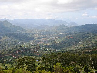
Korogwe District also known as Korogwe District Council is one of the eleven districts of Tanga Region in Tanzania. The District covers an area of 6,534 km2 (2,523 sq mi). It is bordered to the northeast by the Lushoto District and north by Bumbuli District. Korogwe District also bordered to the east by the Mkinga District and the Muheza District, to the South by the Handeni Rural District and the Korogwe Urban District, and to the West by the Kilimanjaro Region. The highest point in Korogwe District is Mafi Peak at 1,442m.
Handeni is a city located in the Handeni Urban District, Tanga Region, Tanzania. It is the capital of both Handeni Town Council and Handeni District. The 2022 national census estimated the population of Handeni Town Council at 108,968.
Handeni Town Council also known as Handeni Urban District is one of the 11 districts of the Tanga Region of Tanzania. The district covers an area of 837.4 km2 (323.3 sq mi). The administrative capital of the district is Mdoe. Handeni Town District is bordered to the east by Handeni District and the west by Kilindi District.

Korogwe Urban District is one of the eleven districts of the Tanga Region of Tanzania. The District covers an area of 225.3 km2 (87.0 sq mi). Korogwe Urban District is bordered to the north by Korogwe Rural District and to the south by Handeni Rural District. The administrative capital of the district is Korogwe town. According to the 2012 Tanzania National Census, the population of Korogwe Urban District was 68,308.
Kwamndolwa is an administrative ward in Korogwe Urban District of Tanga Region in Tanzania. The ward covers an area of 43.2 km2 (16.7 sq mi), and has an average elevation of 297 m (974 ft). According to the 2012 census, the ward has a total population of 5,160.
Magunga is an administrative ward in Korogwe Urban District of Tanga Region in Tanzania. The ward covers an area of 8.5 km2 (3.3 sq mi), and has an average elevation of 326 m (1,070 ft). According to the 2012 census, the ward has a total population of 9,519.
Manundu is an administrative ward in Korogwe Urban District of Tanga Region in Tanzania. The ward covers an area of 4.5 km2 (1.7 sq mi), and has an average elevation of 328 m (1,076 ft). According to the 2012 census, the ward has a total population of 17,499.
Mtonga is an administrative ward in Korogwe Urban District of Tanga Region in Tanzania. The ward covers an area of 14.8 km2 (5.7 sq mi), and has an average elevation of 334 m (1,096 ft). According to the 2012 census, the ward has a total population of 10,369.
Ngombezi is an administrative ward in Korogwe Urban District of Tanga Region in Tanzania. The ward covers an area of 34.2 km2 (13.2 sq mi), and has an average elevation of 366 m (1,201 ft). According to the 2012 census, the ward has a total population of 5,346.
Old Korogwe is an administrative ward in Korogwe Urban District of Tanga Region in Tanzania. The ward covers an area of 26.7 km2 (10.3 sq mi), and has an average elevation of 314 m (1,030 ft). According to the 2012 census, the ward has a total population of 6,394.


