
Pangani District is one of the eight districts and one of 11 administrative councils in Tanga Region in north eastern Tanzania. As of the 2012 census, the population was Pangani district was 54,025, making it the least populous district in Tanga region. The district seat (capital) and largest settlement in Pangani district is the town of Pangani. The district is named after the historic Pangani River.

Tanga Region is one of Tanzania's 31 administrative regions. The region covers an area of 26,667 km2 (10,296 sq mi). The region is comparable in size to the combined land area of the nation state of Burundi. The regional capital is the municipality of Tanga city. Located in northeast Tanzania, the region is bordered by Kenya and Kilimanjaro Region to the north; Manyara Region to the west; and Morogoro and Pwani Regions to the south. It has a coastline to the east with the Indian Ocean. According to the 2012 national census, the region had a population of 2,045,205.
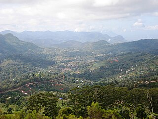
Lushoto is one of the eleven districts of Tanga Region in Tanzania. It is bordered to the northeast by Kenya, to the east by the Muheza District, to the northwest by the Kilimanjaro Region, west by Korogwe District and to the south by the Bumbuli District. The district's capital and largest town is Lushoto.

Muheza District, officially the, Muheza District Council is one of eleven administrative districts of Tanga Region in Tanzania. The District covers an area of 1,498 km2 (578 sq mi). It is bordered to the north by Mkinga District, to the east by Tanga and the Indian Ocean, to the south by the Pangani District and Handeni District, and to the west by the Korogwe District. The district is comparable in size to the land area of Guadeloupe. The town of Muheza, after which the district is named, serves as its administrative capital. According to the 2012 Tanzania National Census, the population of Muheza District had decreased to 204,461; this is less than ten years before, because Mkinga District was created that same year. The highest point in Muheza District is Kimbo Peak at 1,063m.

Elerai is an administrative ward in Arusha District, Arusha Region of Tanzania. It is one of 19 urban administrative wards in the municipality. The ward is bordered by Olasiti ward to the west, Kiranyi ward to the north, Ngarenaro ward to the east, Sombetini to the south and, a tiny portion of Unga L.T.D ward to the southeast. The ward covers an area of 3.746 km2 and ranks number eleven in the area in Arusha city. The ward is home to the national National College of Tourism, the African Court and Tanzania National Parks Authority (TANAPA)'s national headquarters, also the Arusha Modern school. The school's famous alumna is Tanzanian recording artist, Vanessa Mdee, who received secondary education there. According to the 2012 census, the ward had a total population of 40,749.

Mkinga District, officially the, Mkinga District Council is one of eleven administrative districts of Tanga Region in Tanzania. It was created from Muheza District in 2007. The District covers an area of 2,712 km2 (1,047 sq mi). The district is comparable in size to the land area of Samoa. The administrative capital of the district is Parungu Kasera. The district is bordered by Tanga District to the south east and Muheza District to the south west. On the east the district is bordered by the Indian Ocean. On the west is Korogwe District and Lushoto District. The latter's northern boundary is a slither of Mkomazi National Park. On the north the district borders Kenya. The highest point in the district is Mhinduro Peak at 913m. The district is home to the Umba Game Controlled Area. According to the 2012 Tanzania National Census, the population of Mkinga District was 118,065.

Korogwe District also known as Korogwe District Council is one of the eleven districts of Tanga Region in Tanzania. The District covers an area of 6,534 km2 (2,523 sq mi). It is bordered to the northeast by the Lushoto District and north by Bumbuli District. Korogwe District also bordered to the east by the Mkinga District and the Muheza District, to the South by the Handeni Rural District and the Korogwe Urban District, and to the West by the Kilimanjaro Region. The highest point in Korogwe District is Mafi Peak at 1,442m.

Zigi River also known as Sigi River, is a river in located in east Tanga Region in Tanzania.

Mombo is one of the 20 wards of the Korogwe District, Tanga Region, Tanzania.
Handeni Town Council also known as Handeni Urban District is one of the 11 districts of the Tanga Region of Tanzania. The district covers an area of 837.4 km2 (323.3 sq mi). The administrative capital of the district is Mdoe. Handeni Town District is bordered to the east by Handeni District and the west by Kilindi District.
The Tanga Coelacanth Marine Park (TCMP) is a Marine park located in Tanga Region, Tanzania. The marine park is around 552 square kilometers, of which 85 square kilometers is terrestrial, covering small coastal parts of Pangani District, Muheza District and Tanga District. The park extends along the coast from 100 km starting from the estuary of the Pangani River to the bay of Tanga City. The Marine parks covers the Islands of Toten, Yambe and Karange Islands. The marine park is home to the famous Coelacanth. The park is also a sanctuary for the African Dugong and Green sea turtle.

Central is an administrative ward in Tanga City Council of Tanga Region in Tanzania. Tanga Bay borders the ward on its northern side. Pemba Channel lies to the east, and Mzingani, Usagara, Ngamiani Kaskazini, and Majengo ward are to the south. The Chumbageni ward is to the west. The ward covers an area of 3.8 km2 (1.5 sq mi), and has an average elevation of 10 m (33 ft). The ward seat is Halmashauri ya Jiji and is home to the Port of Tanga. According to the 2012 census, the ward has a total population of 5,739.

Chumbageni(Kata ya Chumbageni in Swahili) is an administrative ward in Tanga City Council of Tanga Region in Tanzania. Tanga Bay and Mzizima Ward, which are separated by the Mkulumuzi River, border the ward to the north. Central ward is to the east. Majengo, Mwanzange, and Nguvumali wards are to the south. Kiomoni ward is to the west. The ward covers an area of 2.5 km2 (0.97 sq mi), and has an average elevation of 23 m (75 ft). According to the 2012 census, the ward has a total population of 14,225.

Kiomoni is an administrative ward in Tanga City Council of Tanga Region in Tanzania. The Mzizima, Gombero, and Mnyenzani wards the latter two of Mkinga, surround the ward on its northern side. Chumbageni and Nguvumali wards are to the east. Maweni and Pongwe wards are located to the south. The Muheza District wards of Mlingoni and Pande Darajani are to the west. The ward covers an area of 83.5 km2 (32.2 sq mi), and has an average elevation of 52 m (171 ft). The ward is home to the Amboni Caves and also the largest limestone mine in the country. According to the 2012 census, the ward has a total population of 6,587.
Kirare is an administrative ward in Tanga City Council of Tanga Region in Tanzania. Marungu forms the ward's northern boundary. Tongoni is to the east. Kigombe ward is in the south. The Muheza District ward of Ngomeni is to the west. The ward covers an area of 55.6 km2 (21.5 sq mi), and has an average elevation of 39 m (128 ft). According to the 2012 census, the ward has a total population of 4,756.
Majengo is an administrative ward in Tanga District of Tanga Region in Tanzania. The ward covers an area of 0.9 km2 (0.35 sq mi), and has an average elevation of 17 m (56 ft). According to the 2012 census, the ward has a total population of 7,482.
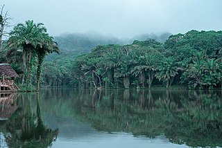
Amani is an administrative ward in Muheza District of Tanga Region in Tanzania. The ward covers an area of 91 km2 (35 sq mi), and has an average elevation of 963 m (3,159 ft). According to the 2012 census, the ward has a total population of 5,553.
Tanganyika is an administrative ward in Muheza District of Tanga Region in Tanzania. The ward covers an area of 6.3 km2 (2.4 sq mi), and has an average elevation of 200 m (660 ft). According to the 2012 census, the ward has a total population of 3,580.

Kisiwani is an administrative ward in Muheza District of Tanga Region in Tanzania. The ward covers an area of 74.5 km2 (28.8 sq mi), and has an average elevation of 304 m (997 ft). According to the 2012 census, the ward has a total population of 7,123.
Magoroto is an administrative ward in Muheza District of Tanga Region in Tanzania. The ward covers an area of 38 km2 (15 sq mi), and has an average elevation of 309 m (1,014 ft). According to the 2012 census, the ward has a total population of 5,769.


