
Tanzania, officially the United Republic of Tanzania, is a country in East Africa within the African Great Lakes region. It borders Uganda to the north; Kenya to the northeast; the Indian Ocean to the east; Mozambique and Malawi to the south; Zambia to the southwest; and Rwanda, Burundi, and the Democratic Republic of the Congo to the west. Mount Kilimanjaro, Africa's highest mountain, is in northeastern Tanzania. According to the 2022 national census, Tanzania has a population of nearly 62 million, making it the most populous country located entirely south of the equator.

Dodoma, officially Dodoma City, is the national capital of Tanzania and the capital of the Dodoma Region, with a population of 765,179. In 1974, the Tanzanian government announced that the capital would be moved from Dar es Salaam to Dodoma for social and economic reasons and to centralise the capital within the country. It became the official capital in 1996. Much of the initial design did not come to fruition for a long time. In May 2023 the national government under President Samia Suluhu unveiled the new State House in Dodoma in a historic event stamping the relocation of government duties to the city. As a result, Dar es Salaam would remain as the commercial and maritime capital of Tanzania with Dodoma retaining the state house Ikulu, and a large number of government functions.

Mafia Island is an island and district of Pwani Region, Tanzania. The island is the third largest in Tanzanian ocean territory, but is not administratively included within the semi-autonomous region of Zanzibar, which has been politically separate since 1890. Mafia Island forms the major part of Mafia District, one of the six administrative districts in the Pwani coastal region. The local archipelago and the main island are sometimes called Chole shamba in Swahili, hinterlands of the former maintown of Chole on Mafia Bay.

Arusha City is a Tanzanian city, with a population of 617,631, and the regional capital of the Arusha Region, with a population of 2,356,255.

Lindi is a historic southern Tanzanian coastal town and regional capital of the Lindi Region. The town is located at the far end of Lindi Bay on the Indian Ocean in southeastern Tanzania. The town is 450 kilometres (280 mi) south of Dar es Salaam and 105 km (65 mi) north of Mtwara, the southernmost coastal town in Tanzania, and gives its name to the surrounding Lindi Region. The Lindi Region is a large, yet sparsely populated, region of Tanzania.

Pwani Region is one of Tanzania's 31 administrative regions. The word "Pwani" in Swahili means the "coast". The regional capital is the town of Kibaha. The Region borders the Tanga Region to the north, Morogoro Region to the west, Lindi Region to the south, and surrounds Dar es Salaam Region to the east. The Indian Ocean also borders the region to its northeast and southeast. The region is home to Mafia Island, the Rufiji delta and Saadani National Park. The region is home to Bagamoyo town, a historical Swahili settlement, and the first colonial capital of German East Africa. According to the 2012 national census, the region had a population of 1,098,668, which was slightly lower than the pre-census projection of 1,110,917. From 2002 to 2012, the region's 2.2 percent average annual population growth rate was the seventeenth-highest in the country. It was also the 21st most densely populated region with 34 people per square kilometre., the region is slightly larger than Belgium.

Musoma is a city in the east shore of lake Victoria of Tanzania. It is the capital of Mara Region, one of the administrative Regions of Tanzania. It also serves as the administrative centre of Musoma Rural District and Musoma Urban District.
Arusha Region is one of Tanzania's 31 administrative regions and is located in the north of the country. The region's capital and largest city is the city of Arusha. The region is bordered by Kajiado County and Narok County in Kenya to the north, the Kilimanjaro Region to the east, the Manyara and Singida Regions to the south, and the Mara and Simiyu regions to the west. Arusha Region is home to Ngorongoro Conservation Area, a UNESCO World Heritage Site. The region is comparable in size to the combined land and water areas of the state of Maryland in the United States.

Kigoma Region is one of Tanzania's 31 administrative regions. The regional capital is the city of Kigoma. Kigoma Region borders Kagera Region, Geita Region, Katavi Region, Tabora Region, DRC and Burundi According to the 2012 national census, the region had a population of 2,127,930, which was higher than the pre-census projection of 1,971,332. For 2002-2012, the region's 2.4 percent average annual population growth rate was tied for the fourteenth highest in the country. It was also the sixteenth most densely populated region with 57 people per square kilometer. With a size of 45,066 square kilometres (17,400 sq mi), the region is slightly smaller than Estonia.

Mwanza Region is one of Tanzania's 31 administrative regions The region covers a land area of 25,233 km2 (9,743 sq mi). The region is comparable in size to the combined land area of the nation state of North Macedonia. Mwanza Region is bordered to the north through Lake Victoria by the Kagera Region and Mara Region, to the east by Simiyu Region, to the south by the Shinyanga Region and to the west by Geita Region. The regional capital is the city of Mwanza. According to the 2022 national census, the region had a population of 3,699,872 and national census of 2012 had 2,772,509. Mwanza Region is the second region with high population in Tanzania after Dar es Salaam Region

Tanga Region is one of Tanzania's 31 administrative regions. The region covers an area of 26,667 km2 (10,296 sq mi). The region is comparable in size to the combined land area of the nation state of Burundi. The regional capital is the municipality of Tanga city. Located in northeast Tanzania, the region is bordered by Kenya and Kilimanjaro Region to the north; Manyara Region to the west; and Morogoro and Pwani Regions to the south. It has a coastline to the east with the Indian Ocean. According to the 2012 national census, the region had a population of 2,045,205.

Same is one of the seven districts of the Kilimanjaro Region of Tanzania. It is bordered to the north by the Mwanga District, to the northeast by Kenya, to the south and southeast by the Korogwe District and Lushoto District of Tanga Region, and to the west by Simanjiro District of Manyara Region. The district capital is the town of Same, Tanzania. The south Pare Mountains are located within the district's boundaries and so is a part of Mkomazi National Park. According to the 2002 Tanzania National Census, the population of the Same District was 212,235. The population had risen to 269,807 according to the 2012 Tanzania National Census.
Lushoto is one of the eleven districts of Tanga Region in Tanzania. It is bordered to the northeast by Kenya, to the east by the Muheza District, to the northwest by the Kilimanjaro Region, west by Korogwe District and to the south by the Bumbuli District. The district's capital and largest town is Lushoto.
As of 2021, there are 31 regions of Tanzania which are divided into 184 districts.

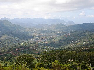
The Usambara Mountains of northeastern Tanzania in tropical East Africa, comprise the easternmost ranges of the Eastern Arc Mountains. The ranges of approximately 90 kilometres (56 mi) long and about half that wide, are situated in the Lushoto District of the Tanga Region. They were formed nearly two million years ago by faulting and uplifting, and are composed of Precambrian metamorphic rocks. They are split into two sub-ranges; the West Usambaras being higher than the East Usambaras, which are nearer the coast and receive more rainfall.

Irente School for the Blind Girls was founded in 1963 by the Lutheran Church in the Usambara Mountains in Lushoto, Tanzania. It is a small residential/primary school. Subjects include craft training and agriculture.

Christianity is the most widely professed religion in Tanzania, with a substantial Muslim minority. Smaller populations of Animists, practitioners of other faiths, and religiously unaffiliated people are also present.

Mkinga is one of the eleven districts of Tanga Region in Tanzania. It was created from Muheza District in 2007. The District covers an area of 1,442 km2 (557 sq mi). The administrative capital of the district is located in a small town called Parungu Kasera. The district is bordered by Tanga District to the south east and Muheza District to the south west. On the east the district is bordered by the Indian Ocean. On the west Korogwe Korogwe District and Lushoto District. On the north the district borders Kenya. The highest point in Korogwe District is Mhinduro Peak at 913m.

Korogwe District also known as Korogwe District Council is one of the eleven districts of Tanga Region in Tanzania. The District covers an area of 6,534 km2 (2,523 sq mi). It is bordered to the northeast by the Lushoto District and north by Bumbuli District. Korogwe District also bordered to the east by the Mkinga District and the Muheza District, to the South by the Handeni Rural District and the Korogwe Urban District, and to the West by the Kilimanjaro Region. The highest point in Korogwe District is Mafi Peak at 1,442m.
Henry Daffa Shekifu is a Tanzanian CCM politician and was Member of Parliament for Lushoto constituency from 1995 to 2015 and Regional Commissioner of Mtwara and Manyara from 2005 to 2010.


