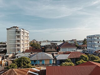
Tanga is a historic city and the capital of Tanga Region. The city is located in the northern port city of Tanzania to the west of the Indian Ocean on Tanga Bay. The city had a population of 393,429 in 2022 and is governed by the Tanga City Council. The city is also a home to the Port of Tanga. The name Tanga means "sail" in Swahili. The city is also the capital of Tanga District.
Sambaa or Shambaa or Shambala is a Bantu language of Tanzania.

The Chagga is a Bantu ethnic group from Kilimanjaro Region of Tanzania and Arusha Region of Tanzania. They are the third-largest ethnic group in Tanzania. They historically lived in sovereign Chagga states on the slopes of Mount Kilimanjaro in both Kilimanjaro Region and Arusha Region.

Tanga Region is one of Tanzania's 31 administrative regions. The region covers an area of 26,667 km2 (10,296 sq mi). The region is comparable in size to the combined land area of the nation state of Burundi. The regional capital is the municipality of Tanga city. Located in northeast Tanzania, the region is bordered by Kenya and Kilimanjaro Region to the north; Manyara Region to the west; and Morogoro and Pwani Regions to the south. It has a coastline to the east with the Indian Ocean. According to the 2022 national census, the region had a population of 2,615,597.
Lushoto is one of the eleven districts of Tanga Region in Tanzania. It is bordered to the northeast by Kenya, to the east by the Muheza District, to the northwest by the Kilimanjaro Region, west by Korogwe District and to the south by the Bumbuli District. The district's capital and largest town is Lushoto.

The Digo are a Bantu ethnic and linguistic group based near the Indian Ocean coast between Mombasa in southern Kenya and northern Tanga in Tanzania. In 1994 the Digo population was estimated to total 305,000, with 217,000 ethnic Digo living in Kenya and 88,000 in Tanzania. Digo people, nearly all Muslims, speak the Digo language, called Chidigo by speakers, a Bantu language.

The Amboni Caves are a limestone cave complex in East Africa. They are located in Kiomoni ward of Tanga in Tanga Region of Tanzania off the Tanga-Mombasa road, 8 km north of Tanga City center. The reported length of the longest cave is 755m. The caves were formed about 150 million years ago during the Jurassic age. It covers an area of 234 km2. According to researchers the area was under water some 20 million years ago. There are altogether ten caves but only one is used for guided tours.
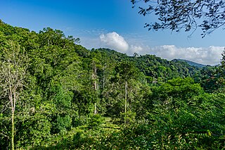
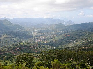
The Amani Forest Reserve, officially listed as Amani Nature Forest Reserve is a protected area located the Muheza and Korogwe Districts in the Tanga Region of Tanzania. The nature reserve was established in 1997 in order to preserve the unique flora and fauna of the East Usambara Mountains. The East and West Usambara Mountains are a biodiversity hotspot. The Amani Nature Reserve includes tropical cloud forest habitats.
The Zigua or in some sources Zigula are a Bantu ethnic and linguistic people hailing from far northern Pwani Region and western southern Tanga Region in Tanzania. In Tanga Region they are the majority in Handeni District, northern Kilindi District and also are a historically significant population south of the Pangani River in Pangani District. They speak the Zigula language. In 1993, the Zigua population was estimated to number 355,000 people, today they number 631,000 people.
The Segeju are a Bantu ethnolinguistic group mostly based in Tanzania's Tanga Region and Kenya's Kwale County. Most Segeju reside in the small coastal strip between the Tanzanian city of Tanga and the Kenyan-Tanzanian border. However, some Segeju have migrated to urban areas in other parts of Tanzania or Kenya, in hopes of better employment opportunities and quality of life. Segeju migration to urban areas often results in severance of community ties, leading to a lack of transmission of important cultural traditions and language.
The Bondei People are a Bantu ethnic group based in Muheza District and Pangani District of eastern Tanga Region in Tanzania. The Bondei speak Kibondei, Bantu language and are culturally related to the Shambaa ethnic group.
Digo (Chidigo) is a Bantu language spoken primarily along the East African coast between Mombasa and Tanga by the Digo people of Kenya and Tanzania. The ethnic Digo population has been estimated at around 360,000, the majority of whom are presumably speakers of the language. All adult speakers of Digo are bilingual in Swahili, East Africa's lingua franca. The two languages are closely related, and Digo also has much vocabulary borrowed from neighbouring Swahili dialects.

Tanga City Council is one of eleven administrative districts of Tanga Region in Tanzania. The District covers an area of 596.5 km2 (230.3 sq mi) of which includes the historic city of Tanga and the Port of Tanga. Tanga district is bordered to the north by Mkinga District, to the east by the Indian Ocean, to the south and west by Muheza District. The district is comparable in size to the land area of Guam. The administrative seat is the ward Central. The district is the administrative and economic center of Tanga Region. In Swahili, the word Tanga means "sail". The City was also the theater for the battle of Tanga. According to the 2022 census, the district has a total population of 393,429.

The following outline is provided as an overview of and topical guide to Tanzania:

Zigi River also known as Sigi River, is a river in located in east Tanga Region in Tanzania.

Kiomoni is an administrative ward in Tanga City Council of Tanga Region in Tanzania. The Mzizima, Gombero, and Mnyenzani wards the latter two of Mkinga, surround the ward on its northern side. Chumbageni and Nguvumali wards are to the east. Maweni and Pongwe wards are located to the south. The Muheza District wards of Mlingoni and Pande Darajani are to the west. The ward covers an area of 83.5 km2 (32.2 sq mi), and has an average elevation of 52 m (171 ft). The ward is home to the Amboni Caves and also the largest limestone mine in the country. According to the 2012 census, the ward has a total population of 6,587.
Kirare is an administrative ward in Tanga City Council of Tanga Region in Tanzania. Marungu forms the ward's northern boundary. Tongoni is to the east. Kigombe ward is in the south. The Muheza District ward of Ngomeni is to the west. The ward covers an area of 55.6 km2 (21.5 sq mi), and has an average elevation of 39 m (128 ft). According to the 2012 census, the ward has a total population of 4,756.
Marungu is an administrative ward in Tanga City Council of Tanga Region in Tanzania. Pongwe forms the ward's northern boundary. Tongoni is to the east. Kirare ward is in the south. Ngomeni of Muheza is located to the west. The ward covers an area of 42.1 km2 (16.3 sq mi), and has an average elevation of 17 m (56 ft). According to the 2012 census, the ward has a total population of 3,025.

Pongwe is an administrative ward in Tanga City Council of Tanga Region in Tanzania. Kiomoni encircles the ward on its northern side. Maweni forms the eastern boundary of the ward. The Marungu is to the south. The Muheza ward of Ngomeni is to the west. The ward covers an area of 77.5 km2 (29.9 sq mi), and has an average elevation of 74 m (243 ft). According to the 2012 census, the ward has a total population of 13,513.
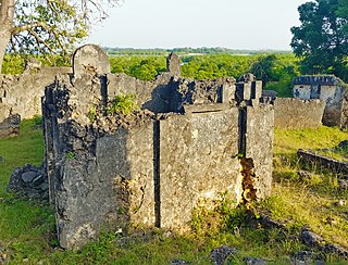
Tongoni is an administrative ward in Tanga City Council of Tanga Region in Tanzania. Tangasisi and Maweni wards form the ward's northern and western boundaries. The Pemba Channel forms the eastern boundary. The Kigombe Ward of Muheza is to the south. The wards of Kirare and Marungu are to the west. The ward covers an area of 44 km2 (17 sq mi), and has an average elevation of 30 m (98 ft). According to the 2012 census, the ward has a total population of 4,594. Tongoni ward is the home to the Tongoni ruins, a Medieval Swahili town.