Kilimanjaro Region

Last updated
Kilimanjaro Region
Mkoa wa Kilimanjaro (Swahili)
Uhuru Peak Mt. Kilimanjaro 1.JPG
Materuni Falls, Uru mashariki.jpg
View of west Kiusa Ward, Moshi.jpg
From top to bottom:
Uhuru Peak, Materuni falls and Moshi City at Night
Nickname: 
The roof of Africa
Tanzania Kilimanjaro location map.svg
Location in Tanzania
Coordinates: 4°8′1.32″S37°48′31.68″E / 4.1337000°S 37.8088000°E / -4.1337000; 37.8088000
CountryFlag of Tanzania.svg  Tanzania
ZoneNorthern
Named for Mount Kilimanjaro
Capital Moshi
Districts
Government
  Regional CommissionerNurdin Babu
Area
  Total13,250 km2 (5,120 sq mi)
  Rank 24th of 31
Highest elevation5,895 m (19,341 ft)
Population
 (2022)
  Total1,861,934
  Rank 19th of 31
  Density140/km2 (360/sq mi)
Demonym Kilimanjaran
Ethnic groups
  Settler Swahili
  Native Chaga. Ngasa & Pare
Time zone UTC+3 (EAT)
Postcode
25xxx
Area code 027
ISO 3166 code TZ-09
HDI (2021)0.640 [1]
medium · 3rd
Website Official website
SymbolsofTanzania
Bird
Scarlet chested sunbird.jpg
Scarlet Tufted Malachite Sunbird
Butterfly
Papilio sjoestedti Aurivillius, 1908.JPG
Kilimanjaro Swallowtail
Fish
Oreochromis hunteri.jpg
Lake Chala tilapia
Mammal
Panthera pardus close up.jpg
Leopard
Tree
Cordia africana00.jpg
Cordia africana
Mineral
Aquamarine P1000141.JPG
Aquamarine

Kilimanjaro Region (Mkoa wa Kilimanjaro in Swahili) is one of Tanzania's 31 administrative regions. [2] The regional capital and largest city is the municipality of Moshi. With the 3rd highest HDI of 0.640 in the country, Kilimanjaro is one among the top five most developed regions of Tanzania. [1] According to the 2012 national census, the region had a population of 1,640,087, which was lower than the pre-census projection of 1,702,207. [3] :page 2 For 2002–2012, the region's 1.8 percent average annual population growth rate was the 24th highest in the country. [3] :page 4 It was also the eighth most densely populated region with 124 people per square kilometer. The most well-known tribes in the Kilimanjaro region are the chagga, rombos (also known as Warombos), and pare. [3] :page 6

Contents

The region forms part of the Northern Tourism Circuit in Tanzania. It is home to the Kilimanjaro National Park (which contains Mount Kilimanjaro), the Mkomazi National Park, the Pare Mountains, Lake Jipe, and Lake Chala. The region is bordered to the north and east by Kenya, to the south by the Tanga Region, to the southwest by the Manyara Region, and to the west by the Arusha Region.

Etymology

In the early 19th century, the Swahili already referred to the mountain as "Kilima Ndsharo" (or "Dscharo"), "The Country of Dschagga," near the coast. In 1848 and 1849, Rebmann said the mountain Swahili names mean "Great Mountain" and "the Mountain of the Caravans" in reference to the mountain that could be seen for a long distance and served as a guide for travelers. He and Krapf found that the term was referred to differently by several nearby populations: the Taita just shortened the coastal Swahili word to "Ndscharo." It was known as "Kima ja Jeu," which is Kamba for "Mountain of Whiteness." It was known as "Ol Donyo Eibor," which is Maasai for "White Mountain." The Chagga themselves, especially the Kilema and Machame, simply called it "Kibo". Kilimandscharo, which Rebmann spelled in German between 1848 and 1849, was changed to "Kilimanjaro" by 1860. [4]

Administrative divisions

Districts

Kilimanjaro Region is divided into one city and six districts, each administered by a council, except Moshi District which has two, one of which serves as the capital of the region.

Districts of Kilimanjaro Region
Map with main roads in greenDistrictPopulation
(2012 Census)
Population
(2017 Estimates) [5]
Kilimanjaro in Tanzania.svg
Moshi District 466,737509,431
Moshi Municipal 184,292201,150
Hai District 210,533229,791
Siha District 116,313126,953
Rombo District 260,963284,834
Mwanga District 131,442143,466
Same District 269,807294,487
Total1,640,0871,790,113

History

Kilimanjaro Region was officially established in 1963 with two districts: Kilimanjaro and Pare. [6] The region was part of the Northern Province in the pre-independence Tanganyika. Northern Province's districts included Arusha and Mbulu, while Pare District was a part of Tanga Province. [7]

Of the region's six districts, four traditionally had Chagga settlements, which are Hai District, Moshi District, Rombo District, and Siha District. The other two, Mwanga District and Same District, have historically included Pare settlements. However, during colonial rule in the late 19th century to the middle of the 20th century, the region was divided into two main districts: Moshi district, which was composed of all the areas settled by the Chagga people on the slopes of the mountain, and Pare district, which was a Pare tribe settlement. [8] The region, from earlier times, had been settled by the people collectively called the Chagga, the Maasai, Wakwavi, and Waarusha (in the lower parts of Mount Kilimanjaro), and the Pare on the Pare mountains. These have been intermingling, trading, and even fighting from time to time for various socio-political reasons. Later, other tribes also migrated to the area.

Geology

Mount Kilimanjaro Mountain at the border of Kenya and Tanzania- Mount Kilimanjaro 09.jpg
Mount Kilimanjaro

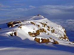
Mount Kilimanjaro lies on a tectonic plate line intersection 80 kilometres (50 mi) east of the tectonically active Rift Valley. [9] The activity that created this stratovolcano dates back less than a million years. Steam and sulphur fumaroles here are indicative of residual activity.

At one stage, most of the summit of Kilimanjaro was covered by an ice cap, probably more than 100 metres (330 ft) deep. Glaciers extended well down the mountain forming moraine ridges, clearly visible now on the southern flanks down to about 4,000 metres (13,000 ft). At present only a small fraction of the glacial cover remains.

Notable people

See also

Related Research Articles

<span class="mw-page-title-main">Moshi, Tanzania</span> City in Tanzania

Moshi is a municipality and the capital of Kilimanjaro region in the north eastern Tanzania. As of 2017, the municipality has an estimated population of 201,150 and a population density of 3,409 persons per km2. In the last official census of 2022, the municipality had a population of 221,733. The municipality is situated on the lower slopes of Mount Kilimanjaro, a dormant volcano that is the highest mountain in Africa. The name Moshi has been reported to refer to the smoke that emanates from the nearby mountain. The municipality covers about 59 square kilometres (23 sq mi) and is the smallest municipality in Tanzania by area.

<span class="mw-page-title-main">Marangu</span> Human settlement in Tanzania

Marangu is a town located in Moshi District of Kilimanjaro Region. it is divided into Marangu East and Marangu west, each with its own village. It is recognized as one of the main gates for climbing Mount Kilimanjaro. it is also famous for being the place where Mangi mkuu of the Chagga Thomas Lenana Marreale was born on June 15, 1915.

<span class="mw-page-title-main">Chaga people</span> Ethnic group from Kilimanjaro Region of Tanzania

The Chagga are a Bantu ethnic group from Kilimanjaro Region of Tanzania. They are the third-largest ethnic group in Tanzania. They historically lived in sovereign Chagga states on the slopes of Mount Kilimanjaro in both Kilimanjaro Region and eastern Arusha Region.

<span class="mw-page-title-main">Manyara Region</span> Region of Tanzania

Manyara Region is one of Tanzania's 31 administrative regions. The regional capital is the town of Babati. According to the 2012 national census, the region had a population of 1,425,131, which was lower than the pre-census projection of 1,497,555. For 2002–2012, the region's 3.2 percent average annual population growth rate was tied for the third highest in the country. It was also the 22nd most densely populated region with 32 people per square kilometre.

<span class="mw-page-title-main">Arusha Region</span> Region of Tanzania

Arusha Region is one of Tanzania's 31 administrative regions and is located in the northeast of the country. The region's capital and largest city is the city of Arusha. The region is bordered by Kajiado County and Narok County in Kenya to the north, the Kilimanjaro Region to the east, the Manyara and Singida Regions to the south, and the Mara and Simiyu regions to the west. Arusha Region is home to Ngorongoro Conservation Area, a UNESCO World Heritage Site. The region is comparable in size to the combined land and water areas of the state of Maryland in the United States.

<span class="mw-page-title-main">Tanga Region</span> Region of Tanzania

Tanga Region is one of Tanzania's 31 administrative regions. The region covers an area of 26,667 km2 (10,296 sq mi). The region is comparable in size to the combined land area of the nation state of Burundi. The regional capital is the municipality of Tanga city. Located in northeast Tanzania, the region is bordered by Kenya and Kilimanjaro Region to the north; Manyara Region to the west; and Morogoro and Pwani Regions to the south. It has a coastline to the east with the Indian Ocean. According to the 2022 national census, the region had a population of 2,615,597.

<span class="mw-page-title-main">Mangi Meli</span> Mangi of Moshi, Kilimanjaro

Meli or Mangi Meli Kiusa bin Rindi Makindara, also known as, , was a king of the Chaga in Moshi, one of the sovereign Chagga states in the late 1890s. Mangi means king in Kichagga. He was hanged by the German colonial government together with 19 other Chagga, Meru, and Arusha leaders. Thomas Kitimbo Kirenga, Sindato Kiutesha Kiwelu, King Ngalami of Siha, Tanzania, King Lolbulu of Meru, King Rawaito of Arusha, King Marai of Arusha, and King Molelia of Kibosho were among the noblemen on 2 March 1900.

The Pare are a Bantu ethnic group. Their ancestral home is on the Pare Mountains of Same District and Mwanga District of Kilimanjaro Region in Northerneast Tanzania. During his visit to Usambara in 1848, German Colonial explorer J. L. Krapf was informed, among other things, that there were the Wapare and Wagweno people living in the north. It seems that the people of South Pare were referred to by the former name, and the people of North Pare by the latter. We refer to both groups by the name Pare nowadays. The Pare Mountains' southern peaks were known as "Mpare," thus it is evident from Pare customs that the name Pare was bestowed upon them by their neighbors to the south. It appears that Upare, as it is now called, consisted of two distinct communities until the early nineteenth century, although they had been progressively merging since the latter part of the eighteenth century.

<span class="mw-page-title-main">Same District, Kilimanjaro</span> District of Kilimanjaro Region, Tanzania

Same is one of the seven districts of the Kilimanjaro Region of Tanzania. It is bordered to the north by the Mwanga District, to the northeast by Kenya, to the south and southeast by the Korogwe District and Lushoto District of Tanga Region, and to the west by Simanjiro District of Manyara Region. The district capital is the town of Same, Tanzania. The south Pare Mountains are located within the district's boundaries and so is a part of Mkomazi National Park. According to the 2002 Tanzania National Census, the population of the Same District was 212,235. The population had risen to 300,303 according to the 2022 Tanzania National Census.

<span class="mw-page-title-main">Districts of Tanzania</span>

As of 2021, there are 31 regions of Tanzania which are divided into 184 districts.

<span class="mw-page-title-main">Mkomazi National Park</span> National Park in Tanzania

Mkomazi National Park is located in northeastern Tanzania on the Kenyan border, in Same District of Kilimanjaro Region and Lushoto District, with a slither of the park in Mkinga District both of Tanga Region. It was established as a game reserve in 1951 and upgraded to a national park in 2006.

<span class="mw-page-title-main">Arusha people</span> Tanzanian ethnic group

The Arusha people are a Bantu ethnic and indigenous group based in the western slopes of mount Meru in Arusha District of Arusha Region in Tanzania. The Maasai regard the Arusha people as related as they were once a part of the immigrant Maasai whom arrived in Arusha in the late 18th century from Kenya. The Arusha people are not to be confused by Arusha residents who are a mix of people of different ethnic backgrounds that are born and reside within the borders of the Arusha Region.

<span class="mw-page-title-main">Machame</span> Historic Chagga State of Kilimanjaro

Machame or Kingdom of Machame, was a historic sovereign Chagga state located in modern day Machame Kaskazini ward in Hai District of Kilimanjaro Region in Tanzania. Historically, the Machame kingdom was in 1889 referred by Hans Meyer as a great African giant, the kingdom was also the largest and most populous of all the Chagga sovereign states on Kilimanjaro, whose ruler as early as 1849 was reckoned as a giant African king with influence extending throughout all Chagga states except Rombo.

<span class="mw-page-title-main">Outline of Tanzania</span> Overview of and topical guide to Tanzania

The following outline is provided as an overview of and topical guide to Tanzania:

<span class="mw-page-title-main">Lake Jipe</span> Lake in Kilimajaro Region, Tanzania and Kenya.

Lake Jipe is an inter-territorial lake straddling the borders of Kenya and Tanzania. On the Kenyan side, it is located south of the village of Nghonji while on the Tanzanian side, it is situated within Mwanga District, in Kilimanjaro Region. The lake is fed mainly by the Lumi River, which descends from Mount Kilimanjaro, as well as streams from the North Pare Mountains, being on the leeward side. The lake's outlet forms the Ruvu River. Kenya's unfenced Tsavo West National Park protects part of the lake's northern shore, while on the Tanzania side Mkomazi Game Reserve is nearby. The lake is known for its endemic fish, as well as water birds, mammals, wetland plants and lake-edge swamps, which can extend 2 kilometres (1.2 mi) from Jipe's shore.

<span class="mw-page-title-main">Nathaniel Mtui</span> Tanzanian historian

Nathaniel Mtui was a Tanzanian historian of Chagga origin born in 1892 in the mtaa of Mshiri in Marangu, Kilimanjaro Region, Tanzania. He was a teacher at the Colonial German Lutheran mission in Marangu. He is known for being the first person of Chagga origin to write history of the Chagga people. He wrote the Chaggan history in Kichagga, German, and Swahili from 1913-1916.

Marangu Defences or Chagga Caves are a man-made defence cave system that was erected in the late 18th century as defence of the Chaga from Maasai raids and expanded the system in the late 19th century as part of the Chagga resistance from the German occupation. The caves are located in various locations within Moshi District of Kilimanjaro Region in Tanzania.

<span class="mw-page-title-main">Ngalami</span> Mangi of Siha (Kibongoto), Kilimanjaro

Ngalami or Ngalami Mmari, also known as, , was one of many kings of the Chagga. He was the king of one of the Chagga states, namely; the Siha Kingdom in what is now modern Siha District of Tanzania's Kilimanjaro Region from the 1880s to 1900. Mangi means king in Kichagga. Ngalami ruled from the Siha seat of Komboko (Kibong'oto) in the 1880s to 1900 when he was executed in Moshi by the Germans alongside 19 other Chagga, Meru and Arusha leaders. The execution of 19 noblemen and leaders on Friday 2nd of March 1900, included noblemen Thomas Kitimbo Kirenga, Sindato Kiutesha Kiwelu, King Meli of Moshi, King Lolbulu of Meru, King Rawaito of Arusha, King Marai of Arusha, and King Molelia of Kibosho.

<span class="mw-page-title-main">Chagga states</span>

The Chagga States or Chagga Kingdoms also historically referred to as the Chaggaland were a pre-colonial series of a Bantu sovereign states of the Chagga people on Mount Kilimanjaro in modern-day northern Kilimanjaro Region of Tanzania. The Chagga kingdoms existed as far back as the 17th century according to oral tradition, a lot of recorded history of the Chagga states, was written with the arrival, and colonial occupation of Europeans in the mid to late 19th century. On the mountain, many minor dialects of one language are divided into three main groupings that are defined geographically from west to east: West Kilimanjaro, East Kilimanjaro, and Rombo. One word they all have in common is Mangi, meaning king in Kichagga. The British called them chiefs as they were deemed subjects to the British crown, thereby rendered unequal. After the conquest, substantial social disruption, domination, and reorganization by the German and British colonial administrations, the Chagga states were officially abolished in 1963 by the Nyerere administration during its third year as the newly independent nation of Tanganyika.

Rengua or Mangi Rengua Kiwaria Kombe (1784–1837), also known as Mangi Rengua of Machame (Mangi Rengua in Kichagga; was a king of the Chaga in Machame, one of the sovereign Chagga states in the early 1800s. Mangi means king in Kichagga. Rengua founded the Kombe dynasty, which ruled until the 1960s, including through times of anarchy and competing independent clans. He consolidated Machame as one of the most powerful kingdoms in Chaggaland and is considered one of the greatest leaders in Machame history. He is also known for massacring Kibosho initiates at Kinduchi, Lyamuro, prompting the rivalry between Kibosho and Machame.

References

  1. 1 2 "Sub-national HDI – Area Database – Global Data Lab". hdi.globaldatalab.org. Archived from the original on 2018-09-23. Retrieved 2020-02-26.
  2. "Postcodes" (PDF). MAMLAKA YA MAWASILIANO TANZANIA. 2021. Archived (PDF) from the original on 25 June 2022. Retrieved 7 July 2022.
  3. 1 2 3 Population Distribution by Administrative Units, United Republic of Tanzania, 2013 Archived 2013-06-12 at the Wayback Machine
  4. Stahl, Kathleen (1964). History of the Chagga people of Kilimanjaro. London: Mouton and Co. p. 38. ISBN   0-520-06698-7.
  5. "Tanzania Population by Regions" (PDF). www.nbs.go.tz. Archived (PDF) from the original on 2018-11-13. Retrieved 2019-01-11.
  6. "Myosorex zinki Kilimanjaro Mouse Shrew : Fr. Musaraigne des bois du Kilimanjaro; Ger. Kilimanjaro-Waldspitzmaus", Mammals of Africa : Hedgehogs, Shrews and Bats, Bloomsbury Publishing, retrieved 2023-11-18
  7. "Historia ya Mkoa | Kilimanjaro Region". www.kilimanjaro.go.tz. Archived from the original on 2021-04-16. Retrieved 2019-03-23.
  8. Murtazina, Farida Gafiullovna (2023-07-05). "Book review: Mironova Ye.V. Laishevsky district in the middle of the 19th – early 20th century: monograph (Kazan, 2022)". From History and Culture of Peoples of the Middle Volga Region. 13 (2): 117–122. doi: 10.22378/2410-0765.2023-13-2.117-122 . ISSN   2410-0765.
  9. "Tectonic Geomorphology of a Plate Boundary". Tectonically Active Landscapes: 213–270. 2009-04-03. doi:10.1002/9781444312003.ch8.