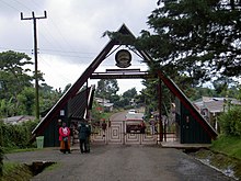
Mount Kilimanjaro is a dormant volcano located in Kilimanjaro Region of Tanzania. It has three volcanic cones: Kibo, Mawenzi, and Shira. It is the highest mountain in Africa and the highest single free-standing mountain above sea level in the world: 5,895 m (19,341 ft) above sea level and about 4,900 m (16,100 ft) above its plateau base. It is the highest volcano in Africa and the Eastern Hemisphere.

Moshi is a municipality and the capital of Kilimanjaro region in the north eastern Tanzania. As of 2017, the municipality has an estimated population of 201,150 and a population density of 3,409 persons per km2. In the last official census of 2022, the municipality had a population of 221,733. The municipality is situated on the lower slopes of Mount Kilimanjaro, a dormant volcano that is the highest mountain in Africa. The name Moshi has been reported to refer to the smoke that emanates from the nearby mountain. The municipality covers about 59 square kilometres (23 sq mi) and is the smallest municipality in Tanzania by area.
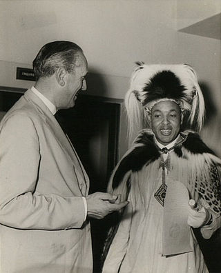
Chief Thomas Lenana Marealle II OBE (June 15, 1915 – February 14, 2007) was the Paramount Chief (Mangi Mkuu) of the Chagga people of Tanzania and a politician.

The Chagga are a Bantu ethnic group from Kilimanjaro Region of Tanzania. They are the third-largest ethnic group in Tanzania. They historically lived in sovereign Chagga states on the slopes of Mount Kilimanjaro in both Kilimanjaro Region and eastern Arusha Region.

Kilimanjaro National Park is a Tanzanian national park located 300 kilometres (190 mi) south of the equator in the Kilimanjaro Region, Tanzania. The park is located near the region of Moshi. The park includes the whole of Mount Kilimanjaro above the tree line and the surrounding montane forest belt above 1,820 metres (5,970 ft). It covers an area of 1,688 square kilometres (652 sq mi), 2°50'–3°10'S 37°10'–37°40'E. The park is administered by the Tanzania National Parks Authority (TANAPA). It was established as a national park in 1973.

Kilimanjaro Region is one of Tanzania's 31 administrative regions. The regional capital and largest city is the municipality of Moshi. With the 3rd highest HDI of 0.640 in the country, Kilimanjaro is one among the top five most developed regions of Tanzania. According to the 2012 national census, the region had a population of 1,640,087, which was lower than the pre-census projection of 1,702,207. For 2002–2012, the region's 1.8 percent average annual population growth rate was the 24th highest in the country. It was also the eighth most densely populated region with 124 people per square kilometer. The most well-known tribes in the Kilimanjaro region are the chagga, rombos, and pare.

Meli or Mangi Meli Kiusa bin Rindi Makindara, also known as, , was a king of the Chaga in Moshi, one of the sovereign Chagga states in the late 1890s. Mangi means king in Kichagga. He was hanged by the German colonial government together with 19 other Chagga, Meru, and Arusha leaders. Thomas Kitimbo Kirenga, Sindato Kiutesha Kiwelu, King Ngalami of Siha, Tanzania, King Lolbulu of Meru, King Rawaito of Arusha, King Marai of Arusha, and King Molelia of Kibosho were among the noblemen on 2 March 1900.
The Rwa or Meru sometimes Rwo are a Bantu ethnic and linguistic group based on the south and eastern slopes of Mount Meru in Meru District of the Arusha Region of Tanzania, the Rwa population is estimated to number 198,000.

Machame or Kingdom of Machame, was a historic sovereign Chagga state located in modern day Machame Kaskazini ward in Hai District of Kilimanjaro Region in Tanzania. Historically, the Machame kingdom was in 1889 referred by Hans Meyer as a great African giant, the kingdom was also the largest and most populous of all the Chagga sovereign states on Kilimanjaro, whose ruler as early as 1849 was reckoned as a giant African king with influence extending throughout all Chagga states except Rombo.
Jackson Kitali was a politician from Moshi, Tanzania.

Himo is a town in the Makuyuni ward of Kilimanjaro Region in Tanzania.

Nathaniel Mtui was a Tanzanian historian of Chagga origin born in 1892 in the mtaa of Mshiri in Marangu, Kilimanjaro Region, Tanzania. He was a teacher at the Colonial German Lutheran mission in Marangu. He is known for being the first person of Chagga origin to write history of the Chagga people. He wrote the Chaggan history in Kichagga, German, and Swahili from 1913-1916.
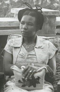
Elifuraha Ndesamburo Urio Marealle was a Tanganyikan politician. In 1955 she was one of the first three women appointed to the Legislative Council.
Marangu Defences or Chagga Caves are a man-made defence cave system that was erected in the late 18th century as defence of the Chaga from Maasai raids and expanded the system in the late 19th century as part of the Chagga resistance from the German occupation. The caves are located in various locations within Moshi District of Kilimanjaro Region in Tanzania.

Ngalami or Ngalami Mmari, also known as, , was one of many kings of the Chagga. He was the king of one of the Chagga states, namely; the Siha Kingdom in what is now modern Siha District of Tanzania's Kilimanjaro Region from the 1880s to 1900. Mangi means king in Kichagga. Ngalami ruled from the Siha seat of Komboko (Kibong'oto) in the 1880s to 1900 when he was executed in Moshi by the Germans alongside 19 other Chagga, Meru and Arusha leaders. The execution of 19 noblemen and leaders on Friday 2nd of March 1900, included noblemen Thomas Kitimbo Kirenga, Sindato Kiutesha Kiwelu, King Meli of Moshi, King Lolbulu of Meru, King Rawaito of Arusha, King Marai of Arusha, and King Molelia of Kibosho.
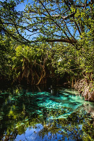
Kikuletwa Hot Springs, also known as Maji Moto(Maji Moto ya Kikuletwa in Swahili) and also Chemka Hot Springs, is a natural geothermal oasis located in Masama Rundugai ward of Hai District in the Kilimanjaro region of Tanzania. Chemka means "boiling" in Swahili, referring to the appearance of how the water emerges from the ground. The hot springs are located approximately 40 kilometers from the town of Moshi, which is a gateway to Mount Kilimanjaro in a village called Chemka. The hot spring waters flow into the Kikuletwa River and eventually find its way to the Pangani River.

The Chagga States or Chagga Kingdoms also historically referred to as the Chaggaland were a pre-colonial series of a Bantu sovereign states of the Chagga people on Mount Kilimanjaro in modern-day northern Kilimanjaro Region of Tanzania. The Chagga kingdoms existed as far back as the 17th century according to oral tradition, a lot of recorded history of the Chagga states, was written with the arrival, and colonial occupation of Europeans in the mid to late 19th century. On the mountain, many minor dialects of one language are divided into three main groupings that are defined geographically from west to east: West Kilimanjaro, East Kilimanjaro, and Rombo. One word they all have in common is Mangi, meaning king in Kichagga. The British called them chiefs as they were deemed subjects to the British crown, thereby rendered unequal. After the conquest, substantial social disruption, domination, and reorganization by the German and British colonial administrations, the Chagga states were officially abolished in 1963 by the Nyerere administration during its third year as the newly independent nation of Tanganyika.
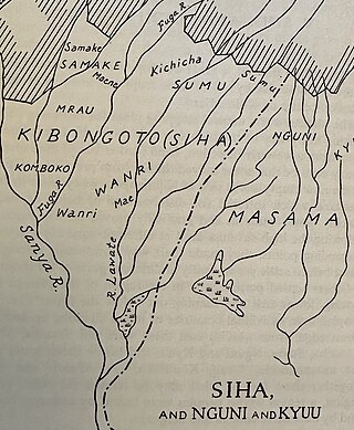
Siha or Kingdom of Siha also sometimes referred to as Kibongoto, was a historic sovereign Chagga state located in modern-day Machame Kaskazini ward in Hai District of Kilimanjaro Region in Tanzania. Siha was located west of the Ushira plateau on Mount Kilimanjaro. The word Mangi means king in Kichagga. The kingdom is known for Mangi Ngalami that was hanged together with 18 other Leaders of the Chagga states including Mangi Meli, by the German colonial regime in 1900.

The Battle of Moshi was fought in what is now modern day city of Moshi in Kilimanjaro Region of Tanzania. The battle was between German Empire led by Von Burlow, and the Moshi kingdom led by Mangi Meli.
The Battle of Kibosho took place on February 12, 1891, in what is now Tanzania's Kilimanjaro Region, in Kibosho. The Kibosho kingdom was ruled by Mangi Sina while the conflict was between the German Empire, commanded by Major Hermann von Wissman.
