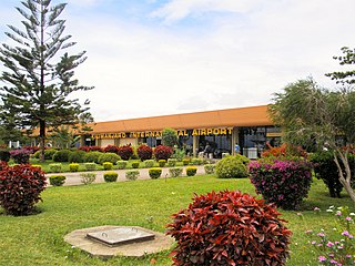
Kilimanjaro International Airport (KIA) (IATA: JRO, ICAO: HTKJ) is an international airport located in Hai District, Kilimanjaro Region, Tanzania. The airport serves the cities of Arusha and Moshi. The airport handled 802,731 passengers in 2014 and mainly serves regional flights as well as a few long-haul services due to its importance as a leisure destination. It is the largest airport in northern Tanzania, by size and passenger volume.

Moshi is a municipality and the capital of Kilimanjaro region in the north eastern Tanzania. As of 2017, the municipality has an estimated population of 201,150 and a population density of 3,409 persons per km2. In the last official census of 2022, the municipality had a population of 221,733. The municipality is situated on the lower slopes of Mount Kilimanjaro, a dormant volcano that is the highest mountain in Africa. The name Moshi has been reported to refer to the smoke that emanates from the nearby mountain. The municipality covers about 59 square kilometres (23 sq mi) and is the smallest municipality in Tanzania by area.

The Chagga are a Bantu ethnic group from Kilimanjaro Region of Tanzania. They are the third-largest ethnic group in Tanzania. They historically lived in sovereign Chagga states on the slopes of Mount Kilimanjaro in both Kilimanjaro Region and eastern Arusha Region.

Kilimanjaro Region is one of Tanzania's 31 administrative regions. The regional capital and largest city is the municipality of Moshi. With the 3rd highest HDI of 0.640 in the country, Kilimanjaro is one among the top five most developed regions of Tanzania. According to the 2012 national census, the region had a population of 1,640,087, which was lower than the pre-census projection of 1,702,207. For 2002–2012, the region's 1.8 percent average annual population growth rate was the 24th highest in the country. It was also the eighth most densely populated region with 124 people per square kilometer. The most well-known tribes in the Kilimanjaro region are the chagga, rombos, and pare.

Arusha Region is one of Tanzania's 31 administrative regions and is located in the northeast of the country. The region's capital and largest city is the city of Arusha. The region is bordered by Kajiado County and Narok County in Kenya to the north, the Kilimanjaro Region to the east, the Manyara and Singida Regions to the south, and the Mara and Simiyu regions to the west. Arusha Region is home to Ngorongoro Conservation Area, a UNESCO World Heritage Site. The region is comparable in size to the combined land and water areas of the state of Maryland in the United States.

Arusha City Council is one of seven administrative districts of Arusha Region in Tanzania. It is surrounded to the south, west and north by Arusha Rural District and to east by Meru District. The district covers an area of 267.0 km2 (103.1 sq mi). The district is comparable in size to the land area of Cayman Islands. The district capital is the city of Arusha. As of 1994, Arusha District was the wealthiest district in Tanzania. According to the 2022 Tanzania National Census, the population of Arusha Urban District was 617,631.

Moshi Urban District is an administrative district located in Kilimanjaro Region of Tanzania. The district is home to regional capital of Kilimanjaro Region, namely Moshi. The district covers an area of 63.39 km2 (24.48 sq mi). The district is surrounded on the west by Moshi Rural District, to the east by the Hai District. According to the 2022 Tanzania National Census, the population of Moshi Urban District was 221,733.
As of 2021, there are 31 regions of Tanzania which are divided into 184 districts.

Nyumba ya Mungu Dam is a Tanzanian, hydroelectric dam located in and operated in Mwanga District, Kilimanjaro Region. It was built in the late 1960s and is Kilimanjaro region's largest artificial water body. Nyumba ya Mungu Reservoir. The reservoir is shared with Moshi District of Kilimanjaro Region and Simanjiro District of Manyara Region. Nyumba ya Mungu means 'House of God'. Its installed capacity is 8 megawatts (11,000 hp).

Meru District, officially the Meru District Council is one of seven districts of the Arusha Region of Tanzania.The District is bordered to the north by Longido District, to the east by Siha and Hai Districts of Kilimanjaro Region, to the south by Simanjiro District of Manyara Region, and to the west by Arusha Rural District and Arusha Urban District. It covers an area of 1,266 km2 (489 sq mi). The district is comparable in size to the land area of Faroe Islands. Meru District has an max elevation of 3,800 m (12,500 ft) at Rhino Point on Mount Meru. The administrative capital of the district is Usa River. According to the 2022 Tanzania National Census, the population of Meru District council was 331,603.

Machame or Kingdom of Machame, was a historic sovereign Chagga state located in modern day Machame Kaskazini ward in Hai District of Kilimanjaro Region in Tanzania. Historically, the Machame kingdom was in 1889 referred by Hans Meyer as a great African giant, the kingdom was also the largest and most populous of all the Chagga sovereign states on Kilimanjaro, whose ruler as early as 1849 was reckoned as a giant African king with influence extending throughout all Chagga states except Rombo.

Tanzania is a country with many tourist attractions. Approximately 38 percent of Tanzania's land area is set aside in protected areas for conservation. There are 17 national parks, 29 game reserves, 40 controlled conservation areas and marine parks. Tanzania is also home to Mount Kilimanjaro, the highest point in Africa.

Lake Jipe is an inter-territorial lake straddling the borders of Kenya and Tanzania. On the Kenyan side, it is located south of the village of Nghonji while on the Tanzanian side, it is situated within Mwanga District, in Kilimanjaro Region. The lake is fed mainly by the Lumi River, which descends from Mount Kilimanjaro, as well as streams from the North Pare Mountains, being on the leeward side. The lake's outlet forms the Ruvu River. Kenya's unfenced Tsavo West National Park protects part of the lake's northern shore, while on the Tanzania side Mkomazi Game Reserve is nearby. The lake is known for its endemic fish, as well as water birds, mammals, wetland plants and lake-edge swamps, which can extend 2 kilometres (1.2 mi) from Jipe's shore.

Elieshi Lema is a Tanzanian writer and publisher, also active in Tanzania's civil society.
Mkomongo is a Village in the Moshi District, Kilimanjaro Region, the United Republic of Tanzania

Beer and alcohol is an integral part of Tanzanian society and local brands hold a strong sense of national pride among the Tanzanian population. There is a considerable amount of brewing and drinking done in the country. Tanzania ranks 6th in Africa for beer consumption and contributes to over 3% of the African consumption. However, over 90% of the national consumption is either homemade or from the informal sector. Bottled beer is expensive for the majority of the population and is almost 6 times more expensive than the maize beers. Nonetheless, beer sales and taxes are a vital part of the Tanzanian economy.
Marangu Defences or Chagga Caves are a man-made defence cave system that was erected in the late 18th century as defence of the Chaga from Maasai raids and expanded the system in the late 19th century as part of the Chagga resistance from the German occupation. The caves are located in various locations within Moshi District of Kilimanjaro Region in Tanzania.

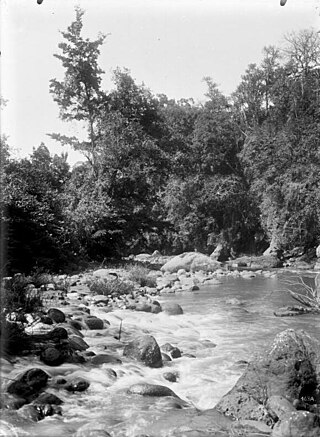
Kikafu River(Mto Kikafu in Swahili) is located in the northern Kilimanjaro Region, Tanzania. It begins in Machame Mashariki ward in Moshi District and drains into the Pangani River. The river plays an important part of Chagga history in the Chagga kingdom of Machame.
Sanya River is located in the northern Kilimanjaro Region of Tanzania. It begins in Livishi ward in Siha District and eventually drains into Kikuletwa River a tributary of the Pangani River. The river plays an important part of Chagga history in the Chagga kingdom of Siha (Kibongoto).


