Kigoma Region

Last updated
Kigoma Region
Mkoa wa Kigoma (Swahili)
Lake shore in Kagongo Ward.jpg
Kigoma High Court, Bangwe Ward, Kigoma.jpg
Mango Row, Kagera Ward, Kigoma-Ujiji.jpg
From top to bottom:
Lake Tanganyika in Kagongo Ward, Kigoma District, Kigoma High Court and Mango row in historic Ujiji
Nickname: 
Tanzania's Sunset Region
Tanzania Kigoma location map.svg
Location in Tanzania
Coordinates: 4°52′56.64″S29°39′41.4″E / 4.8824000°S 29.661500°E / -4.8824000; 29.661500
CountryFlag of Tanzania.svg  Tanzania
ZoneWestern
Named after Kigoma
CapitalKigoma
Districts
Government
  Regional CommissionerThobias Andengenye
Area
  Total
37,040 km2 (14,300 sq mi)
  Rank 8th of 31
Highest elevation
(Kicherere)
1,917 m (6,289 ft)
Population
 (2022) [1]
  Total
2,470,967
  Rank 10th of 31
  Density67/km2 (170/sq mi)
Demonym Kigoman
Ethnic groups
  Settler Swahili, Arab, Congolese & Burundians
  Native Ha, Vinza, Tongwe, Jiji & Holoholo
Time zone UTC+3 (EAT)
Postcode
47xxx
Area code 028
ISO 3166 code TZ-05 [2]
HDI (2021)0.520 [3]
low · 19th of 25
Website Official website
SymbolsofTanzania
Bird
Die Vogel Ost-Afrikas. Baron Carl Claus von Deer Decken's Reisen in Ost-Africa. Bd. 4 (1870) (20923923426).jpg
Livingstone's turaco
Butterfly
Large striped swordtail (Graphium antheus) male underside Bobiri.jpg
Large striped swordtail
Fish
Cyphotilapia frontosa - Karlsruhe Zoo 01.jpg
Frontosa Kigoma
Mammal
Schimpanse Pan troglodytes Zoo Augsburg-05.jpg
Chimpanzee
Tree
Zanthoxylum gilletii-Africa Museum (2).jpg
East African Satinwood
Mineral
Rock salt (halitite) (Klodawa Salt Dome, Zechstein Formation, Upper Permian; Klodawa Salt Mine, central Poland) 1 (15953564096).jpg
Halite

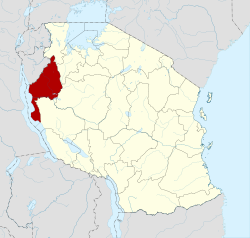
Kigoma Region (Mkoa wa Kigoma in Swahili) is one of Tanzania's 31 administrative regions, with the city of Kigoma as the regional capital. Kigoma Region borders Kagera Region, Geita Region, Katavi Region, Tabora Region, DRC and Burundi According to the 2012 national census, the region had a population of 2,127,930, which was higher than the pre-census projection of 1,971,332. [4] :page 2 For 2002–2012, the region's 2.4 percent average annual population growth rate was tied for the fourteenth highest in the country. [4] :page 4 It was also the sixteenth most densely populated region with 57 people per square kilometer. [4] :page 6 With a size of 45,066 square kilometres (17,400 sq mi), [5] the region is slightly smaller than Estonia (45,227 square kilometres (17,462 sq mi)).

Contents

Geography

Most of Kigoma Region showing the Malagarasi River. Malagarasi River.jpg
Most of Kigoma Region showing the Malagarasi River.

Kigoma Region resides in the northwestern corner of Tanzania, on the eastern shore of Lake Tanganyika. The region lies at about 5° south and 30° east of Greenwich and is bordered to the north by both Burundi and the Kagera Region. To the east, it is bordered by the Geita Region and Tabora Regions, to the south by the Katavi Region, and to the west by Lake Tanganyika, which forms a border with the Democratic Republic of the Congo. [6]

Uvinza Salt, Uvinza Ward.jpg
Uvinza Salt mined in Uvinza District.
Nyerere House Marker, Kitongoni Ward, Ujiji.jpg
Nyerere's house marker in Kitongoni.
Swahili home, Kigoma Ward.jpg
Swahili home in Kigoma.
Kigoma habor from Kibirizi Ward.jpg
Kigoma harbor from Kibirizi
Lake Tanganyika view, Kigoma Ward.jpg
Lake Tanganyika view from Kigoma Ward

The region's total area is 45,066 square kilometres (17,400 sq mi), [7] of which 37,037 square kilometres (14,300 sq mi) is land and 8,029 square kilometres (3,100 sq mi) is water. [6] The region's total area is just 161 square kilometres (62 sq mi) less than that of Estonia. As of 1998, approximately 20,000 square kilometres (7,700 sq mi) was in forests and 12,000 square kilometres (4,600 sq mi) was suitable for grazing or farming. [6]

Kigoma Region is on a plateau that slopes from the northeast at about 1,750 metres (5,740 ft) down to 800 metres (2,600 ft) at the shore of lake Tanganyika. [8] The topography in the north and east is gently rolling hills that gradually become steeper as they get closer to the Albertine Rift margin. [8] The most important river is the Malagarasi, with the Luiche and the Ruchugi being the two other major rivers draining the region. [8]

History

Stanley meeting Livingstone Rencontre de Livingstone - How I found Livingstone (fr).png
Stanley meeting Livingstone

In precolonial Africa the region was a source of ivory and slaves. [9] Tabora and Ujiji were Arab staging areas for shipments to the coast. [10] It was visited by the early European explorers Richard Burton, John Speke, David Livingstone, and Henry Morton Stanley. In fact, Stanley met Livingstone in Ujiji on the shores of Lake Tanganyika on 27 October 1871. [11] In colonial times, the Kigoma area was known as the Western Region and the capital was Tabora. [9]

Administrative divisions

Districts

Kigoma Region is divided into six districts, each administered by a council except Kigoma and Kasulu which administered with two council each.: [4]

Districts of Kigoma Region
MapDistrictPopulation
(2012)
Kigoma in Tanzania.svg Buhigwe District Buhigwe District Council254,342
Kakonko District Kakonko District Council167,555
Kasulu District Kasulu District Rural Council425,794
Kasulu District Urban Council208,244
Kibondo District Kibondo District Council261,331
Kigoma District Kigoma District Rural Council211,566
Kigoma-Ujiji Municipal Council215,458
Uvinza District Uvinza District Council383,640
Total2,127,930

Demographics

Kigoma Region has a total population of 2,127,930. [12]

Ha people are the largest ethnic group living here, alongside other significant populations are of the Wabembe, Wamanyema, Watongwe and Wavinza, Sukuma and Haya. Approximately 150,000 refugees from Burundi and almost another 80,000 refugees from the Democratic Republic of Congo reside in three refugee camps in the Kigoma Region, named Nyarugusu, Mtendeli and Nduta.

Notable people from Kigoma Region

References

  1. "Matokeo ya Sensa". sensa.nbs.go.tz (in Swahili). Dodoma, Tanzania: National Bureau of Statistics (Tanzania). Archived from the original on 31 October 2022. Retrieved 1 November 2022.
  2. "IS0 3166". ISO. Retrieved 2022-10-09.
  3. "Sub-national HDI - Area Database - Global Data Lab". hdi.globaldatalab.org. Archived from the original on 2018-09-23. Retrieved 2020-02-26.
  4. 1 2 3 4 Population Distribution by Administrative Units, United Republic of Tanzania, 2013 Archived 2013-06-12 at the Wayback Machine
  5. Statistical Abstract 2011, Tanzania National Bureau of Statistics Archived 2013-11-05 at the Wayback Machine
  6. 1 2 3 "Kigoma region: Socio-Economic Profile" (PDF). Planning Commission, Dar es Salaam, and the Regional Commissioner's Office, Kigoma. December 1998. p. 1. Archived (PDF) from the original on 30 May 2004.
  7. "National Sample Census of Agriculture 2002/03: Volume Vq: Regional Report: Kagera Region, Tanzania National Bureau of Statistics, December 2007, page 1" (PDF). Archived (PDF) from the original on 2016-03-04. Retrieved 2013-05-15.
  8. 1 2 3 Planning 1998 , p. 2
  9. 1 2 Head of Regional Office, Kigoma (2011), "2.0 Historia Fupi ya Mkoa (Short History of the Region)" (PDF), Taarifa ya Miaka 50 ya Uhuru wa Tanzania Mkoa wa Kigoma (Information concerning 50 Years of the Independence of Tanzania: Kigoma) (in Swahili), Office of Prime Minister, pp. 4–7, archived from the original (PDF) on 2012-08-27
  10. Dugard, Martin (2004). Into Africa: The Epic Adventures of Stanley and Livingstone . New York: Broadway Books. p.  68. ISBN   978-0-7679-1074-3. [not the first edition]
  11. Dugard 2004 , p. 266
  12. "2012 population and housing census: population distribution by administrative areas" (PDF). National Bureau of Statistics. p. 103. Archived from the original (PDF) on June 12, 2013.