Kigoma

Last updated
Kigoma
Kigoma kituo cha reli 2012 Tamino.jpg
Kigoma Railway Station
Tanzania relief location map.svg
Red pog.svg
Kigoma
Location of Kigoma.
Coordinates: 4°53′S29°38′E / 4.883°S 29.633°E / -4.883; 29.633
CountryFlag of Tanzania.svg  Tanzania
Region Kigoma Region
District Kigoma-Ujiji District
Area
  Total92.67 km2 (35.78 sq mi)
Elevation
775 m (2,543 ft)
Population
 (2022 census) [1]
  Total232,388
  Density2,500/km2 (6,500/sq mi)
Time zone UTC+3 (East Africa Time)
Area code 028
Climate Aw
Website Town website

Kigoma is a city and lake port in Kigoma-Ujiji District in Tanzania, on the northeastern shores of Lake Tanganyika and close to the border with Burundi and The Democratic Republic of the Congo. It serves as the capital for the surrounding Kigoma Region and has a population of 232,388 (2022 census). [1] The city is situated at an elevation of 775 metres (2,543 ft).

Contents

The historic trading town of Ujiji is located 6 kilometres (3.7 mi) south-east of Kigoma.

Transport

Maritime transport

The Kigoma port during the day time. Lake Tanganyika ,Kigoma port ,Tanzania.jpg
The Kigoma port during the day time.

Kigoma is one of the busiest ports on northeastern Lake Tanganyika since historically it was the only one that had a functioning railway connection (the one at Kalemie in The Democratic Republic of the Congo is not operational at the moment[ when? ]), a direct link to the ocean port at Dar es Salaam. Kigoma Port in the Kigoma Bay has a wharf of two hundred metres (660 ft) and several cranes and is equipped to handle shipping containers. [2] However, the bay is suffering from silting up as a result of soil erosion from surrounding hills, and the water depths at wharfside has diminished from 6 metres (20 ft) to 1.8 metres (5 ft 11 in). This may threaten the economic growth of the port. In May 2007 the Tanzanian Government announced a plan to create an economic zone at the port to stimulate trade and to ensure stable economic growth of the Port for the government in Power in 2015 and 2020. [3]

The MV Liemba sails every week from Kigoma to Mpulungu in Zambia at the southern tip of Lake Tanganyika, stopping at a number of other lakeside towns in Tanzania on the way. The MV Mwongozo sails from Kigoma to Baraka, Uvira and Bujumbura at the northern tip of the lake, although it is not working currently. There are other ships from Congo and Burundi that sail to Kigoma Port every week.

Road

Current road connections to and from Kigoma are improving. However, travellers should be advised to take extra precautions when travelling. A gravel road links the town northeast to the national road network, and earth tracks link north to Burundi and southeast to Sumbawanga. [4]

Railway

The Kigoma rail station during the day time. KIGOMA RAILWAY STATION.jpg
The Kigoma rail station during the day time.

The Central Line of the Tanzania Railways Corporation runs from Kigoma to the Port of Dar es Salaam on to the Indian Ocean coast via Tabora and Dodoma. It was completed in 1915 when Kigoma was part of German East Africa. In Tabora, there is a connection to Mwanza on Lake Victoria, with ferry connections to other Tanzanian lakeshore places, and formerly Uganda. At Tabora, you can also travel by train to Mpanda. For a time in early 2010, the line was closed [5] but service has apparently been restored. [6]

Airport

The city is served by Kigoma Airport which has scheduled service to Bujumbura and Dar es Salaam.


Climate

Kigoma has a tropical savanna climate (Köppen Aw) with a wet season between November and April.

Climate data for Kigoma
MonthJanFebMarAprMayJunJulAugSepOctNovDecYear
Average high °C (°F)27
(80)
27
(81)
27
(81)
27
(81)
28
(83)
28
(83)
28
(83)
29
(84)
29
(85)
29
(84)
27
(80)
26
(79)
28
(82)
Average low °C (°F)19
(67)
19
(67)
19
(67)
19
(67)
19
(67)
18
(64)
17
(63)
18
(64)
20
(68)
21
(69)
20
(68)
19
(67)
19
(67)
Average rainfall mm (inches)120
(4.8)
130
(5)
150
(5.9)
130
(5.1)
43
(1.7)
5.1
(0.2)
2.5
(0.1)
5.1
(0.2)
18
(0.7)
48
(1.9)
140
(5.6)
130
(5.3)
921.7
(36.5)
Source: Weatherbase [7]

Related Research Articles

There are a number of systems of transport in Burundi, including road and water-based infrastructure, the latter of which makes use of Lake Tanganyika. Furthermore, there are also some airports in Burundi.

Transport in Tanzania includes road, rail, air and maritime networks. The road network is 86,472 kilometres (53,731 mi) long, of which 12,786 kilometres (7,945 mi) is classified as trunk road and 21,105 kilometres (13,114 mi) as regional road. The rail network consists of 3,682 kilometres (2,288 mi) of track. Commuter rail service is in Dar es Salaam only. There are 28 airports, with Julius Nyerere International being the largest and the busiest. Ferries connect Mainland Tanzania with the islands of Zanzibar. Several other ferries are active on the countries' rivers and lakes.

<span class="mw-page-title-main">Tabora</span> City of Tabora Region in Tanzania

Tabora is the capital of Tanzania's Tabora Region and is classified as a municipality by the Tanzanian government. It is also the administrative seat of Tabora Urban District. According to the 2012 census, the district had a population of 226,999.

<span class="mw-page-title-main">Kigoma Region</span> Region of Tanzania

Kigoma Region is one of Tanzania's 31 administrative regions. The regional capital is the city of Kigoma. Kigoma Region borders Kagera Region, Geita Region, Katavi Region, Tabora Region, DRC and Burundi According to the 2012 national census, the region had a population of 2,127,930, which was higher than the pre-census projection of 1,971,332. For 2002-2012, the region's 2.4 percent average annual population growth rate was tied for the fourteenth highest in the country. It was also the sixteenth most densely populated region with 57 people per square kilometer. With a size of 45,066 square kilometres (17,400 sq mi), the region is slightly smaller than Estonia.

<span class="mw-page-title-main">Central Line (Tanzania)</span> Railway line in Tanzania

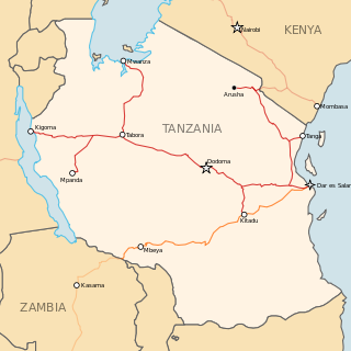
The Central Line, formerly known as the Tanganyika Railway is the most important railway line in Tanzania, apart from TAZARA. It runs west from Dar es Salaam to Kigoma on Lake Tanganyika via Dodoma. A branch leads to Mwanza on Lake Victoria.

<span class="mw-page-title-main">Kalemie</span> Provincial capital and city in Tanganyika, DR Congo

Kalemie, formerly Albertville or Albertstad, is a town on the western shore of Lake Tanganyika in the Democratic Republic of the Congo. The town is next to the outflow of the Lukuga River from Lake Tanganyika to the Lualaba River.

MV <i>Liemba</i>

MV Liemba, formerly Graf Goetzen or Graf von Goetzen, is a passenger and cargo ferry that runs along the eastern shore of Lake Tanganyika. The Marine Services Company Limited of Tanzania sails her, with numerous stops to pick up and set down passengers, between the ports of Kigoma, Tanzania and Mpulungu, Zambia.

<span class="mw-page-title-main">Rail transport in Tanzania</span>

Rail transport in Tanzania is conducted by two companies. It has historically used narrow gauge trackage, but planning and construction of new standard gauge lines is underway as of 2017.

<span class="mw-page-title-main">Uvinza</span> District of Kigoma Region, Tanzania

Uvinza is one of the eight administrative districts of Kigoma Region in Tanzania. Uvinza is bordered to the northwest by Kigoma District and Kigoma-Ujiji District. North of the district is bordered by Kasulu District. Lake Tanganyika borders the district on the west. Mpanda District in Katavi Region boders the district to the south and Kaliua District in Tabora Region borders the district to the east. The district is named in honor of the Vinza people whom the western part of district was their historic kingdom. Southern Uvinza District is home to the Mahale Mountains National Park. A unique park that is home to both Chimpanzees and lions in the same habitat.

There are several planned railway lines in Rwanda, including a line to Tanzania. Historical railways are limited to three industrial railways.

<span class="mw-page-title-main">Railway stations in Tanzania</span>

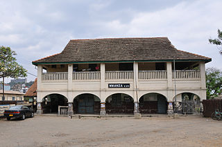
Railway stations in Tanzania include:

<span class="mw-page-title-main">Tanzania Ports Authority</span> Public corporation in Tanzania

Tanzania Ports Authority (TPA) is a parastatal public corporation acting under the aegis of the Ministry of Infrastructure Development, that has the responsibility "to manage and operate" the ocean ports and lake ports of the country of Tanzania. The Tanzania Ports Authrorty headquarters are located in Mchafukoge ward of Ilala District in Dar es Salaam Region. It is a member of the Port Management Association of Eastern and Southern Africa.

<span class="mw-page-title-main">Tanzania Railways Limited</span>

The Tanzania Railways Corporation(TRC) is a state-owned enterprise that runs one of Tanzania's two main railway networks. the Headquarters are located in Mchafukoge, Ilala District, Dar es Salaaam Region.

<span class="mw-page-title-main">History of rail transport in Tanzania</span>

The history of rail transport in Tanzania began in the late nineteenth century.

<span class="mw-page-title-main">Marine Services Company Limited</span>

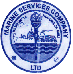
Marine Services Company Limited (MSCL) is a Tanzanian company that operates ferries, cargo ships and tankers on three of the African Great Lakes, namely Lake Victoria, Lake Tanganyika and Lake Nyasa. It provides services to neighbouring Burundi, DR Congo, Zambia and Malawi.

<span class="mw-page-title-main">Katavi Region</span> Region of Tanzania

Katavi Region is one of Tanzania's 31 administrative regions. The region covers an area of 45,843 km2 (17,700 sq mi). The region is comparable in size to the combined land area of the nation state of Estonia. Kagera Region is bordered to the east by Tabora Region. The region is bordered to the south by Rukwa Region and Songwe Region. Lastly, Katavi borders DRC on Lake Tanganyika to the west. The region derives its name from Katavi, the spirit of lake Tanganyika. The regional capital city is Mpanda. According to the 2012 national census, the region had a population of 564,604.

Burundi–Tanzania relations are bilateral relations between Burundi and Tanzania. Burundi is a strategic partner of Tanzania in many areas, particularly trade. Since Burundi is a landlocked country, almost 80% of its goods are moved through by road to Dar es Salaam Port. Tanzania has also been a strategic partner in mediating the political tensions in the country.

<span class="mw-page-title-main">Tabora offensive</span> Military offensive in Africa during World War I

The Tabora Offensive was an Anglo-Belgian offensive into German East Africa, which ended with the Battle of Tabora in the north-west of German East Africa, it was part of the East African Campaign in World War I. The forces of the Belgian Congo crossed the border with German East Africa and captured the port city of Kigoma and the city of Tabora. In August a smaller Lake Force under the command of the South African brigadier general Crewe, launched a parallel attack from Uganda, also aimed at taking Tabora. The completion of the Tabora Offensive not only left much of the Ruanda-Urundi territory under Belgian military occupation but gave the Allies control of the important Tanganjikabahn railway.

The Tanzania Standard Gauge Railway is a railway system, under construction, linking the country to the neighbouring countries of Rwanda and Uganda, and through these two, to Burundi and the Democratic Republic of the Congo, as part of East African Railway Master Plan. The new Standard Gauge Railway (SGR), is intended to replace the old, inefficient metre-gauge railway system.

The Uvinza–Musongati–Gitega Railway is a planned railway line linking the town of Uvinza in Tanzania to the city of Gitega in Burundi, passing through the town of Musongati, Burundi, close to the common border between the two countries.

References

  1. 1 2 Citypopulation.de Population of cities & urban localities in Tanzania
  2. Tanzania Railways Corporation: Kigoma Port. Archived 2007-09-28 at the Wayback Machine Retrieved 30 May 2007.
  3. Daily News, Tanzania: "500m/- set for Kigoma economic zone." Archived 2007-08-31 at the Wayback Machine Monday, May 28, 2007. Retrieved 31 May 2007.
  4. Michelin Motoring and Tourist Map (2000): "No 955 Africa Central and South". Michelin, Paris.
  5. The Economist , Burundi's election; Pretty squalid; East Africa’s weakest new component Retrieved 24 July 2010
  6. The Washington Post , A train ride across Tanzania Retrieved 9 October 2010
  7. "Weatherbase: Historical Weather for Kigoma, Tanzania". Weatherbase. 2011. Retrieved on November 24, 2011.

Further reading