Sumbawanga

Last updated
Sumbawanga
Sumbawanga Memorial.jpg
The Sumbawanga Memorial.
World location map (equirectangular 180).svg
Red pog.svg
Sumbawanga
Location of Sumbawanga.
Africa relief location map.jpg
Red pog.svg
Sumbawanga
Sumbawanga (Africa)
Tanzania relief location map.svg
Red pog.svg
Sumbawanga
Sumbawanga (Tanzania)
Coordinates: 7°58′S31°37′E / 7.967°S 31.617°E / -7.967; 31.617
CountryTanzania
Region Rukwa Region
District Sumbawanga Urban
Population
 (2022 census)
   Urban
[1]
303,986
Website Regional website

Sumbawanga is a city located in western Tanzania. It is the capital of Rukwa Region and the municipal seat of Sumbawanga Urban District with postcode number 55100 . The district had a population of approximately 303,986 based on the 2022 census. [2] Sumbawanga lies in the territory of the Wafipa Fipa tribe and so many people speak Kifipa, as well as Kiswahili, the most widely used language of Tanzania. The name of the town literally translates as "throw away your witchcraft", thought to be a warning from local spiritual "healers" to any bringing in superstitions and practices relating to spiritual healers from other areas. Until the 1980s approximately, Sumbawanga was a place where many witch doctors were located. Though fewer in numbers, there are still some healers who practice both in town and in the surrounding smaller villages on the plateau. The town has the largest hospital in the region, Rukwa General Hospital, which is government funded, as well as the smaller Dr. Atiman Hospital administrated and run by the Catholic Diocese of Sumbawanga.

Contents

The town acts as a supply and commercial center for the Rukwa Region and some governmental agencies are to be found there, notably the transport department for the region. Sumbawanga has both Libori and Moravian conference centres. A modest-size market is in the town centre where local produce may be found. This includes maize, rice, fruit, poultry and fish (from Lake Tanganyika and Lake Rukwa). Many imported plastic goods and electronics are available as well as bicycles and spares. Although there are several fuel outlets, supply can be quite erratic because of the difficulties of transport from the coast.

The local economy is largely dependent on agriculture and small locally owned businesses. There is very limited industry or production in the town. Significant improvement has been made on the road to Mbeya as it is sealed to enable reliable all-weather access year round. This road, and its continuation north to Mpanda and Tabora or Kigoma, is now passable throughout the year. The Tanzanian government has had contracts in place for upgrading large sections of these roads. The town can be reached by flights operated by Auric Air [3] or by bus from Mbeya which lies to the south with train links to the town of Kapiri Mposhi in Zambia, to Dar es Salaam. Rail is also available through Tabora from Mpanda in the north. Mpanda also has an airport with a 2 km sealed runway.

Education

Sumbawanga has many schools and colleges, including:

  1. Chem Chem Secondary School
  2. Sumbawanga Secondary School
  3. St. Aggrey Chanji High School
  4. Mazwi Secondary School
  5. St. Aggrey Teaching College
  6. Musoma Utalii College
  7. Chem Chem Teaching College
  8. Kanda Secondary School
  9. Mafulala Secondary School
  10. Msakila Secondary School
  11. St.Mary's Colledge

Climate

Climate data for Sumbawanga (1991-2020, extremes 1989-present)
MonthJanFebMarAprMayJunJulAugSepOctNovDecYear
Record high °C (°F)30.0
(86.0)
34.4
(93.9)
29.0
(84.2)
30.0
(86.0)
32.0
(89.6)
29.0
(84.2)
29.7
(85.5)
31.7
(89.1)
30.1
(86.2)
33.0
(91.4)
32.0
(89.6)
32.0
(89.6)
34.4
(93.9)
Mean daily maximum °C (°F)23.3
(73.9)
23.8
(74.8)
24.0
(75.2)
23.8
(74.8)
24.2
(75.6)
24.1
(75.4)
23.9
(75.0)
24.9
(76.8)
26.1
(79.0)
26.5
(79.7)
25.3
(77.5)
23.8
(74.8)
24.5
(76.1)
Mean daily minimum °C (°F)14.4
(57.9)
14.2
(57.6)
14.2
(57.6)
14.0
(57.2)
12.0
(53.6)
9.3
(48.7)
8.6
(47.5)
10.0
(50.0)
12.5
(54.5)
14.5
(58.1)
14.9
(58.8)
14.6
(58.3)
12.8
(55.0)
Record low °C (°F)9.9
(49.8)
9.1
(48.4)
10.3
(50.5)
8.4
(47.1)
6.4
(43.5)
4.7
(40.5)
3.2
(37.8)
1.6
(34.9)
6.5
(43.7)
9.0
(48.2)
5.9
(42.6)
8.4
(47.1)
1.6
(34.9)
Average precipitation mm (inches)178.2
(7.02)
134.1
(5.28)
142.6
(5.61)
85.1
(3.35)
17.5
(0.69)
2.0
(0.08)
0.7
(0.03)
1.6
(0.06)
3.1
(0.12)
9.6
(0.38)
81.4
(3.20)
197.2
(7.76)
853.1
(33.59)
Average precipitation days (≥ 1 mm)17.513.814.48.52.20.30.10.30.41.77.217.383.7
Source: NOAA [4] [5]

Twin Town/Sister City

Related Research Articles

Transport in Tanzania includes road, rail, air and maritime networks. The road network is 86,472 kilometres (53,731 mi) long, of which 12,786 kilometres (7,945 mi) is classified as trunk road and 21,105 kilometres (13,114 mi) as regional road. The rail network consists of 3,682 kilometres (2,288 mi) of track. Commuter rail service is in Dar es Salaam only. There are 28 airports, with Julius Nyerere International being the largest and the busiest. Ferries connect Mainland Tanzania with the islands of Zanzibar. Several other ferries are active on the countries' rivers and lakes.

<span class="mw-page-title-main">Dodoma</span> Capital of Tanzania

Dodoma, officially Dodoma City, is the capital of Tanzania and the administrative capital of both Dodoma Municipal Council and the entire Dodoma Region, with a population of 765,179. In 1974, the Tanzanian government announced that Tanzania's federal capital would be moved from Dar es Salaam to Dodoma for social and economic reasons and to centralise the capital within the country. It became the official capital in 1996.

<span class="mw-page-title-main">Kigoma</span> City and lake port in Kigoma Region, Tanzania

Kigoma is a city and lake port in Kigoma-Ujiji District in Tanzania, on the northeastern shores of Lake Tanganyika and close to the border with Burundi and The Democratic Republic of the Congo. It serves as the capital for the surrounding Kigoma Region and has a population of 232,388. The city is situated at an elevation of 775 metres (2,543 ft).

<span class="mw-page-title-main">Tabora</span> City of Tabora Region in Tanzania

Tabora is the capital of Tanzania's Tabora Region and is classified as a municipality by the Tanzanian government. It is also the administrative seat of Tabora Urban District. According to the 2012 census, the district had a population of 226,999.

<span class="mw-page-title-main">Rukwa Region</span> Region of Tanzania

Rukwa Region(Mkoa wa Rukwa in Swahili) is one of Tanzania's 31 administrative regions The region covers a land area of 27,765 km2 (10,720 sq mi). The region is comparable in size to the combined land area of the nation state of Haiti. Rukwa Region is bordered to the north by Katavi Region, to the east by Songwe Region, to the south by the nation of Zambia and to the west by Lake Tanganyika, which forms a border between Tanzania and the Democratic Republic of the Congo. The regional capital is the municipality of Sumbawanga. According to the 2022 national census, the region had a population of 1,540,519.

<span class="mw-page-title-main">Mbeya</span> City in Mbeya Region, Tanzania

Mbeya is a city located in south west Tanzania, Africa, with an urban population of 649,000 in 2023. Mbeya is the capital of the surrounding rural Mbeya region.

<span class="mw-page-title-main">Mbeya Region</span> Region of Tanzania

Mbeya Region is one of Tanzania's 31 administrative regions. The region covers an area of 35,954 km2 (13,882 sq mi). The region is comparable in size to the combined land area of the nation state of Guinea Bissau. Mbeya Region is bordered to the east by Singida Region, Iringa Region and Njombe Region. The region is bordered to the south by Malawi and Lake Nyasa. To the north the region borders southern Tabora Region. Lastly, Mbeya is bordered to the west by Songwe Region. The regional capital is the city of Mbeya. According to the 2022 national census, the region had a population of 2,343,754.

<span class="mw-page-title-main">Sikonge District</span> District in Tabora Region, Tanzania

Sikonge District is one of the seven districts of the Tabora Region of Tanzania. The town of Sikonge is the administrative seat. The district has an area of 27,873 square kilometres (10,762 sq mi), but 26,834 square kilometres (10,361 sq mi) of it is in forest and game reserves. It is bordered to the northwest by Urambo District, to the north by Uyui District, to the east by Manyoni District of Singida Region, to the south by Chunya District of Mbeya Region, and to the southwest by Mlele District of Katavi Region.

<span class="mw-page-title-main">Mpanda District</span> District of Katavi Region, Tanzania

Mpanda District is one of the five districts of the Katavi Region of Tanzania. Its administrative seat is the city of Mpanda. The district is bordered to the northwest by the Kigoma Region, to the northeast by the Tabora Region, to the east by the Mbeya Region, to the southeast by the Sumbawanga Urban District, to the southwest by the Nkasi District and to the west by Lake Tanganyika.

Tunduma is a city in Songwe Region, Tanzania, on the border between Tanzania and Zambia. It has border posts for both the Tanzam Highway and the TAZARA railway linking the two countries. It is located 103 km southwest of Mbeya. It is also the junction for the tarmac road which runs via Sumbawanga through the remote far western districts of Tanzania to Kasulu and Kibondo in the north-west. According to the 2022 census, it has a population of 219,309. Tunduma can be the most famous border city within SADCC countries and it is informerly known as the gateway to East Africa with the neighbour country of Zambia. Once you are in Tunduma, you can enter the town of Nakonde, in Zambia either on foot or other means of transportation.

<span class="mw-page-title-main">Outline of Tanzania</span> Overview of and topical guide to Tanzania

The following outline is provided as an overview of and topical guide to Tanzania:

<span class="mw-page-title-main">Makambako</span> Town and district in Njombe Region, Tanzania

Makambako is a medium-sized town and district in the Njombe Region of the Tanzanian Southern Highlands, located roughly 40 miles north of Njombe city by road. It is located at junction of the A104 and B4 roads between Njombe, Iringa, and Mbeya. Its population according to the 2002 Tanzanian census was 51,049.

Mpanda is a city in Katavi Region of Tanzania, East Africa with a postcode number 50100. It is the administrative centre of Katavi Region, Mpanda District and is itself one of the four districts of the region.

<span class="mw-page-title-main">Katavi Region</span> Region of Tanzania

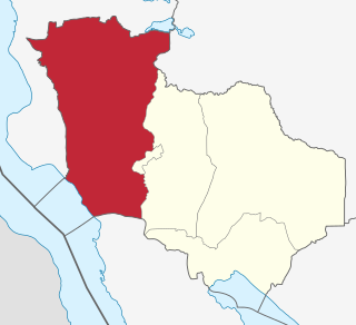
Katavi Region is one of Tanzania's 31 administrative regions. The region covers an area of 45,843 km2 (17,700 sq mi). The region is comparable in size to the combined land area of the nation state of Estonia. Katavi Region is bordered to the east by Tabora Region. The region is bordered to the south by Rukwa Region and Songwe Region. Lastly, Katavi borders DRC on Lake Tanganyika to the west. The region derives its name from Katavi, the spirit of lake Tanganyika. The regional capital city is Mpanda. According to the 2022 national census, the region had a population of 1,152,958.

FPCT Tumaini Secondary School, is the private school located in the Southern part of Tanzania in Katavi region, formerly Rukwa Region.

The Ufipa Plateau is a highland in southwestern Tanzania. It lies mostly in Rukwa Region, near the border with Zambia. The plateau is named for the Fipa people who inhabit it.

The Iringa–Sumbawanga High Voltage Power Line, also Iringa–Mbeya–Tunduma–Sumbawanga High Voltage Power Line, is a high voltage electricity power line, under development in Tanzania. The 400 kiloVolts power line will connect the high voltage substation at Iringa, to another high voltage substation at Sumbawanga. 

<span class="mw-page-title-main">Mpimbwe District</span> District in Katavi, Tanzania

Mpimbwe District is a district council in the Katavi Region of Tanzania's Southern Highlands established in 2012. The district lies in the south of the region on Lake Rukwa.

<span class="mw-page-title-main">Nsimbo District</span> District in Katavi, Tanzania

Nsimbo District is a district council in the Katavi Region of Tanzania's Southern Highlands established in 2012. The district lies in the middle of the region east of the city of Mpanda. It is a tropical environment of mostly forest reserves and agricultural economy.

References

  1. Citypopulation.de Population of cities & urban localities in Tanzania
  2. Citypopulation.de Population of Sumbawanga municipality
  3. "Auric Air". Auric Air Services Ltd. March 30, 2012. Retrieved March 30, 2012.
  4. "Sumbawanga Climate Normals 1991–2020". National Oceanic and Atmospheric Administration . Retrieved January 8, 2024.
  5. "Global Surface Summary of the Day - GSOD". National Oceanic and Atmospheric Administration . Retrieved January 8, 2024.

Commons-logo.svg Media related to Sumbawanga at Wikimedia Commons