Mbeya

Last updated

Mbeya
Mbeya Tanzania.jpg
Mbeya City .jpg
Mbalizi Mbeya Tanzania -0006.jpg
From Top : The mountains surrounding Mbeya, Mbeya City Roads & an aerial view of Mbeya City.
Tanzania relief location map.svg
Red pog.svg
Mbeya
Location of Mbeya
Africa relief location map.jpg
Red pog.svg
Mbeya
Mbeya (Africa)
Coordinates: 08°54′00″S33°27′00″E / 8.90000°S 33.45000°E / -8.90000; 33.45000
Country Flag of Tanzania.svg Tanzania
Region Mbeya
District Mbeya Urban
Incorporated city1 July 2005
Government
  MayorDavid Mwashilindi
Area
  Urban
97.5 sq mi (252.5 km2)
Population
 (2022 census) [1]
   Urban
541,603
  Urban density5,600/sq mi (2,100/km2)
Time zone UTC+3 (EAT)
Area code 025
Climate Cwb
Website Country website

Mbeya is a city located in south west Tanzania, Africa, with an urban population of 649,000 in 2023. [2] Mbeya is the capital of the surrounding rural Mbeya region (population, with Mbeya, totals approx. 2 million). [3]

Contents

Mbeya is situated at an altitude of 1,700 metres (5,500 ft), and sprawls through a narrow highland valley surrounded by a bowl of high mountains. The main language is colloquial Swahili, and the English language is extensively taught in schools.

History

Following the 1906 gold rush, Mbeya was founded as a gold mining town in the 1920s. The TAZARA railway later attracting farming migrants and small entrepreneurs to the area. [4] [5] Mbeya and its district were administered by the British until 1961. Mbeya Region was created in 1961. Mbeya City is now a growing metropolis and business centre for the southern regions and the neighbouring countries of Malawi, Zambia and Congo. The city is well connected with an all-weather road that forms part of the "Great North Road" running from Cape Town to Alexandria. The city has several tribes including the Safwa, Nyakyusa, Nyiha and Ndali all being agricultural peoples. [6] Mbeya also boasts as one of the regions that form the bread basket of Tanzania.

Economy and infrastructure

Local government is administered via the Mbeya Urban District authority and a Regional Commissioner.

Fuel tank trucks in Mbeya. Petro Tank Mbeya 68817216515540 20200102 144346443.jpg
Fuel tank trucks in Mbeya.

Mbeya has weather with enough rainfall and fertile soil which enable it to be the largest producer of maize, rice, bananas, beans, potatoes (Irish & sweet), soya nuts and wheat in the entire country. Tanzania has a free market in agricultural produce, and Mbeya transports vast amounts of its maize to other areas of Tanzania. There is also extensive animal husbandry, with dairy cattle predominating. Mbeya is also the biggest producer of high-value export and cash crops in Tanzania; those crops are coffee (arabica), tea, cocoa, pyrethirum and spices. [7] There is some smallholder cultivation of tobacco. Firewood is collected by women and girls, from the wooded valleys and mountainsides. Bamboo is naturally abundant in the forests, and there are plans to teach local people about this versatile plant and its many uses. Some gold is still mined in the rural Chunya District, by artisan miners.

Mbeya is considered to be heading the Southern Highlands Regions, that's why there is a Mbeya Referral Hospital which serves the whole of the Southern Highlands regions. The Bank of Tanzania, Mbeya Cement Company, Afri Bottlers Company Coca-Cola Company, SBC Tanzania Ltd Pepsi Cola Company, Tanzania Breweries Limited, NMB, TIB, Mbozi Coffee Curing Limited, Tukuyu Tea Company, Tanzania Oxygen Limited TOL - KYEJO, CRDB all these serve as zonal representative for southern Highlands. There are also a number of companies and statutory organisations with zonal offices in Mbeya.

Education

Mbeya city the capital of the surrounding rural Mbeya region Mbeya-1.jpg
Mbeya city the capital of the surrounding rural Mbeya region

Besides a growing number of secondary schools, Mbeya has some institutes of higher learning education. Among the better known ones are the following five:

Geography and climate

Loleza Mountain Mbeya.jpg
Loleza Mountain

Mbeya has an subtropical highland climate (Cwb, according to the Köppen climate classification), with humid summers and dry winters. The general range of temperature is between −6 °C or 21.2 °F during highlands mornings and 29 °C or 84.2 °F during lowland afternoons. The weather from June until October, is dry and cold. The heaviest rainfall occurs during the months of December to April, and annual rainfall averages approximately 900 millimetres or 35 inches.

Climate data for Mbeya
MonthJanFebMarAprMayJunJulAugSepOctNovDecYear
Mean daily maximum °C (°F)24
(75)
23
(73)
23
(73)
23
(73)
22
(72)
21
(70)
21
(70)
22
(72)
25
(77)
27
(80)
27
(80)
25
(77)
23
(74)
Mean daily minimum °C (°F)14
(57)
14
(57)
14
(57)
13
(55)
11
(52)
9
(48)
8
(46)
9
(48)
11
(52)
13
(55)
13
(56)
14
(57)
12
(53)
Average rainfall mm (inches)190
(7.5)
160
(6.3)
160
(6.3)
110
(4.5)
18
(0.7)
0
(0)
0
(0)
2.5
(0.1)
2.5
(0.1)
15
(0.6)
56
(2.2)
140
(5.4)
854
(33.7)
Source: Weatherbase [8]

The area around Mbeya town (especially in Tukuyu) enjoys abundant and reliable rainfall which stimulates abundant agriculture on the rich volcanic soils.

Mountain reserves and wildlife

An aerial view of Mbeya. Mbalizi Mbeya Tanzania -0003.jpg
An aerial view of Mbeya.
The road outside of Mbeya. Mbeya road.jpg
The road outside of Mbeya.

The area around Mbeya has been called the "Scotland of Africa". The hills are clad in heather and bracken, but botanically they are more closely related to the Fynbos (fine bush) of South Africa's Western Cape Province than the Highlands of Scotland. The nearest mountain to Mbeya is Loleza Mountain, which rises over and behind the town. Mbeya Peak is visible but some distance away.

Mount Rungwe is the highest mountain in the wider Mbeya region and it dominates the skyline for several kilometers around. It is composed of ten or more dormant volcanic craters and domes. Rising above the small town of Tukuyu, at 2,960 metres or 9,711 feet, Rungwe is southern Tanzania's highest peak, and is among the highest in the country after some of the peaks in northern Tanzania such as Mount Kilimanjaro (5,895 metres or 19,341 feet) and Mount Meru (4,565 metres or 14,977 feet). Mount Rungwe is surrounded by a catchment forest reserve that was gazetted in 1949. This forest reserve incorporates montane forest, upper montane forest and montane grassland, with lesser amounts of bushland and heath at the upper elevations, found in low bushes along streams and at the edges of montane forest. The forest is home to a variety of significant forest flora and fauna, including the threatened Abbott's Duiker. The forest is regarded as an important bird area, with two species listed as vulnerable. The most notable creatures are Rungwe bush vipers and Colobus monkeys.

Also ecologically important are the Poroto Mountains, south-east of Mbeya. In 2005, a completely new species of large monkey, the Kipunji, was discovered living in the southern highlands to the south-west of Mbeya. The Mbeya region has not yet been closely studied by scientists.

The Kitulo Plateau, famous for its orchids and display of native flora is now within the designated Kitulo National Park.

Forests in the area, even in the reserves, continue to be encroached upon and degraded. However, there has also been extensive tree and forest planting, which ensures the local firewood supply. There is a small illicit trade in orchid bulbs, which is thought to be endangering the survival of some species.

Transport

Railway Station

The Mbeya Railway Station. Mbeya Railway Station.jpg
The Mbeya Railway Station.

Mbeya is served by the Mbeya Railway Station which is near the A104 or via the TAZARA railway line from the capital (approx. 600-miles, two overnight passenger trains per week). [9]

Mbeya can be reached by road on the A-7 highway from Dar es Salaam , There are paved roads which connects Mbeya city with the other towns like Tukuyu through Uyole, Tunduma via TANZAM highway and Chunya to Tabora through Isanga.

Airport

Mbeya connects to the rest of Tanzania by air through Songwe International Airport which was opened in December 2012. It is one of four major airports available in Tanzania. Auric Air and Tropical Air fly from Songwe to Dar es Salaam. [10] Songwe International Airport is within Mbeya region and not in the new Songwe region. The airport is about 25 kilometers from Mbeya City center and about 2-3 kilometers from Mbeya and Songwe regions boundary which is Songwe river.

Tourism

The rains normally start in October and end around May, followed by a dry and cold spell between June and September. Conventional tourism is not a major contributor to the local economy and there are no visible months with peak tourism.

The city lies in the Rift Valley and is considered Csb by the Köppen-Geiger system. The cooler and mountainous climate in the town attracts mainly locals from other parts of the country and foreigners for the game watching and trout fishing. The local government has begun trying to widen tourism beyond animal and wild game viewing, and have invested in producing better mapping and developing a local tourist center. [11]

Well-defined hiking trails have been established to enable hikers to reach the elevated areas and bio-diverse highlands, although the trails need to be properly mapped. For self-sufficient hikers, there are various routes in the Poroto Mountains around the small town of Tukuyu.

Some notable local tourist attractions in the area include:

  1. Kitulo National Park
  2. Ruaha National Park
  3. Lake Nyasa
  4. Mbozi meteorite
  5. Mwalalo Water Falls
  6. The great rift valley viewing point
  7. Kisiba/masoko crater lake

The city also has various rock and cave painting sites. Many of the rock sites have still been undocumented by the Antiequits department and provide a looking glass into the traditional cultures of the local surrounding communities.

The city also has a significant number of transit passengers heading towards Lusaka/Malawi from Dar es Salaam Port that often make a stop in the city for overnight lodging or food.

Sports and culture

The city is represented in the Tanzanian Premier League by Mbeya City FC that is owned by Mbeya City Council and Prisons FC, owned by the Tanzanian Prisons Service based in Mbeya and they play their home matches at the Sokoine Stadium.

Ihefu is a club from Ubaruku, Mbarali district that was promoted to the Tanzanian premier league at the 2020–2021 season and currently play their home matches at the Highland Estate Stadium.

Notable people

Twin towns – sister cities

Related Research Articles

<span class="mw-page-title-main">Mbeya Region</span> Region of Tanzania

Mbeya Region is one of Tanzania's 31 administrative regions. The region covers an area of 35,954 km2 (13,882 sq mi). The region is comparable in size to the combined land area of the nation state of Guinea Bissau. Mbeya Region is bordered to the east by Singida Region, Iringa Region and Njombe Region. The region is bordered to the south by Malawi and Lake Nyasa. To the north the region borders southern Tabora Region. Lastly, Mbeya is bordered to the west by Songwe Region. The regional capital is the city of Mbeya. According to the 2022 national census, the region had a population of 2,343,754.

<span class="mw-page-title-main">Chunya District</span> District of Mbeya Region, Tanzania

Chunya District is one of the seven districts of Mbeya Region, Tanzania. It is bordered to the north by Tabora Region, to the northeast by Singida Region, to the east by Mbarali District, to the south by Mbeya Rural District, and to the west by Songwe District.

<span class="mw-page-title-main">Mbarali District</span> District of Mbeya Region, Tanzania

Mbarali District is one of the seven districts of Mbeya Region, Tanzania. It is bordered to the north by Iringa region and east by Njombe region. To the south the district is bordered by Mbeya Rural District and to the west by Chunya District.

<span class="mw-page-title-main">Mbeya Rural District</span> District of Mbeya Region, Tanzania

Mbeya Rural District is one of the seven districts of Mbeya Region, Tanzania. It is bordered to the north by Mbarali District and Chunya District, to the south by Mbeya Urban District and Rungwe District, to the east by Iringa Region and to the west by Mbozi District.

<span class="mw-page-title-main">Kyela District</span> District of Mbeya Region, Tanzania

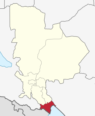
Kyela is one of the seven districts of Mbeya Region, Tanzania. It is bordered to the north by Rungwe District, to the northeast by Njombe Region, to the southeast by Lake Nyasa, to the south by Malawi and to the west by Ileje District.

As of 2021, there are 31 regions of Tanzania which are divided into 184 districts.

<span class="mw-page-title-main">Tukuyu</span> Town in Rugwe District, Mbeya Region, Tanzania

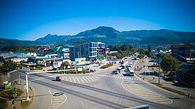
Tukuyu, known as Neu Langenburg during the German colonial rule, is a hillside town that lies about 36 miles (58 km) south of the city of Mbeya, at an elevation of around 5,000 ft (1,500 m) in the highland Rungwe District of southern Tanzania, East Africa. Tukuyu town has a moderate to cool temperature ranging from 10 °C in May and June to mid 20 °C in around November. The town and surrounding areas are green all year round due to the almost year-round convectional rains resulting from Lake Nyasa(Lake Malawi).Tukuyu town is divided into several wards include; Kawetere, Msasani, Bulyaga and Bagamoyo.

Ngonga is an administrative ward in the Kyela district of the Mbeya Region of Tanzania. The village is on Lake Nyasa by the Songwe River that forms the Tanzania and Malawi border, and thirty minute drive from the border crossing in Kasumulu. The ward covers an area of 339.4 square kilometres (131.0 sq mi) with an average elevation of 482 metres (1,581 ft).

Kinyala is an administrative ward in the Rungwe District of the Mbeya Region of Tanzania. In 2016 the Tanzania National Bureau of Statistics report there were 14,185 people in the ward, from 12,871 in 2012.

Bonde la Usongwe, is a administrative ward in Mbeya Rural in the Mbeya Region of Tanzania. The ward covers an area of 103.1 square kilometres (39.8 sq mi) with an average elevation of 1,431 metres (4,695 ft).

<span class="mw-page-title-main">Kitulo National Park</span> Protected area in Tanzania

Kitulo National Park is a protected area of montane grassland and montane forest on the Kitulo Plateau in the southern highlands of Tanzania. The park is at an elevation of 2,600 metres (8,500 ft) between the peaks of the Kipengere and Poroto mountains and covers an area of 412.9 square kilometres (159.4 sq mi), lying in Mbeya Region and Njombe Region. The park is administered by Tanzania National Parks (TANAPA) and is the first national park in tropical Africa to be established primarily to protect its flora.

The Southern Highlands is a highland region in southwestern Tanzania, at the northern end of Lake Malawi. The highlands include portions of Mbeya, Njombe, Rukwa, Ruvuma, and Songwe regions, bordering Malawi, Mozambique, and Zambia. Mbeya is the largest city in the highlands.

Mbeya Range is a volcanic mountain range in Mbeya Region, in southwestern Tanzania, East Africa. It forms an arc just north of the town of Mbeya and includes Loleza Peak, Mbeya Peak, Nyanuwa Peak, and Pungulumo. The range is at the junction of the eastern Gregory Rift and western Albertine Rift valleys. and is in Rungwe volcanic province. The Songwe Scarp terminates the Rukwa Trough at its southeast end and forms the northwestern side of the Mbeya Range.

<span class="mw-page-title-main">Katavi Region</span> Region of Tanzania

Katavi Region is one of Tanzania's 31 administrative regions. The region covers an area of 45,843 km2 (17,700 sq mi). The region is comparable in size to the combined land area of the nation state of Estonia. Katavi Region is bordered to the east by Tabora Region. The region is bordered to the south by Rukwa Region and Songwe Region. Lastly, Katavi borders DRC on Lake Tanganyika to the west. The region derives its name from Katavi, the spirit of lake Tanganyika. The regional capital city is Mpanda. According to the 2022 national census, the region had a population of 1,152,958.

Tulia Ackson is the Speaker of the National Assembly of Tanzania, in office since 2022. She was appointed as a Member of Parliament by President John Magufuli. On the 27th October 2023, she was elected the President of the IPU through the meeting convened at Luanda Angola were she passed other contestants by a great margin, the results that gave Tanzania United Republic a high reputation.

<span class="mw-page-title-main">Tanzam Highway</span> Highway from Lusaka, Zambia to Dar es Salaam, Tanzania

The Tanzam Highway leads from Lusaka in Zambia to Dar es Salaam in Tanzania. The highway was built from 1968 to 1973 in several stages and was intended to provide seaport access for Zambia and to expand the transport options for Zambia, Malawi and the then Zaire.

The Umalila Mountains are a mountain range in southern Tanzania, on the border with Malawi. The Umalila Mountains are part of Tanzania's Southern Highlands.

The Rungwe dwarf galago is a newly identified species of eastern dwarf galago. Specimens were first collected in the 1930s, but were identified as different species. A formal description of the species is presently being made.

References

  1. Citypopulation.de Population of the major cities in Tanzania
  2. PopulationStat Population of Mbeya, city and urban area
  3. "Socio economic profile" (PDF). www.mbeya.go.tz. 2018. Retrieved 26 January 2021.
  4. "Xinhua Headlines: Chinese-built railways foster friendship, development in Africa over last four decades - Xinhua | English.news.cn". www.xinhuanet.com. Archived from the original on 27 February 2019. Retrieved 15 August 2020.
  5. Intern (3 July 2012). "Freedom Railway". Boston Review. Retrieved 15 August 2020.
  6. Charsley, S. "The Princes of Nyakyusa" (PDF). core.ac.uk. Retrieved 26 January 2021.
  7. "Agricultural Sector Report". documents1.worldbank.org. 1983. Retrieved 26 January 2021.
  8. "Weatherbase: Historical Weather for Mbeya, Tanzania". Weatherbase. 2011. Retrieved 24 November 2011.
  9. "Tanzam Journey". Railways Africa. 9 November 2010. Archived from the original on 23 April 2012. Retrieved 21 June 2011.
  10. 2014 route map, "Route Map". www.fastjet.com. 2014. Retrieved 26 January 2021.
  11. "Tourism and Wildlife | Mbeya Region". www.mbeya.go.tz. Archived from the original on 8 February 2016. Retrieved 7 February 2016.

08°54′S33°27′E / 8.900°S 33.450°E / -8.900; 33.450