Morogoro

Last updated
Morogoro
Mji kasoro bahari
Morogoro clock tower.jpg
Morogoro clock tower
Tanzania relief location map.svg
Red pog.svg
Morogoro
Location of Morogoro
Africa relief location map.jpg
Red pog.svg
Morogoro
Morogoro (Africa)
Coordinates: 06°49′27″S37°39′48″E / 6.82417°S 37.66333°E / -6.82417; 37.66333
CountryTanzania
Region Morogoro Region
District Morogoro District
Area
[1]
  Total360 km2 (140 sq mi)
  Land260 km2 (100 sq mi)
  Water100 km2 (40 sq mi)
Highest elevation
509 m (1,669 ft)
Population
 (2022 census) [2]
  Total471,409
  Density1,300/km2 (3,400/sq mi)
Time zone GMT +3
Climate Aw
Website www.morogoro.go.tz

Morogoro is a city located in the eastern part of Tanzania, approximately 196 kilometers (122 miles) west of Dar es Salaam. [3] It serves as the capital of the Morogoro Region. Informally, it is referred to as Mji kasoro bahari, which translates to city short of an ocean/port. [4]

Contents

In Morogoro, the non-profit organization APOPO trains Gambian pouched rats known as HeroRATS, for landmine detection as well as the detection of tuberculosis. Notably, the Sokoine University of Agriculture is based in Morogoro. The city is also home to various missions that provide educational and medical facilities, benefiting the local community.

Mindu Dam

The Mindu Dam, situated on the Ngerengere River, stands as the primary water source for Morogoro, meeting approximately 80% of the city's water demands. Despite its critical role, the dam has been a focal point of controversy since its inception in 1978. The formation of a reservoir behind the dam has led to a surge in bilharzia infection rates, [5] while the city's water supply has suffered pollution from mercury runoff originating from nearby gold mining activities. [6] Furthermore, deforestation in the dam's vicinity has accelerated sedimentation, adversely affecting its capacity. [7]

In an effort to mitigate these challenges, a program funded by USAID/MCC, with a budget of $8.31 million, was initiated in 2012–13. The program's objective was to restore the quality of drinking water resources from the Uluguru Mountains by establishing an inlet and treatment plant near the Regional Governance offices at the upper end of Boma Road. This initiative aimed to benefit the Morogoro Water Supply Authority (MORUWASA) by enhancing the quality and availability of water resources.

Morogoro panorama.jpg
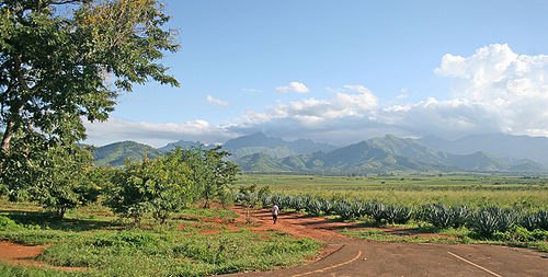
A panorama of Morogoro Town showing the town and the activities of the people. The Nguru Mountains can be seen in the background.


Geography, agriculture, and climate

The city is situated at the foothills of the Uluguru Mountains and serves as a significant agricultural center in the region. Morogoro is the site of many Sisal plantations. [8] The climate in Morogoro is warm and tropical with average highs ranging from 32°C (90.7°F) to 27.8°C (82.6°F), and lows ranging from 16.7°C (62.1°F) to 12.4°C (54.3°F).

Climate data for Morogoro (1991–2020)
MonthJanFebMarAprMayJunJulAugSepOctNovDecYear
Mean daily maximum °C (°F)32.2
(90.0)
32.6
(90.7)
31.8
(89.2)
29.8
(85.6)
28.7
(83.7)
28.1
(82.6)
27.8
(82.0)
28.7
(83.7)
30.3
(86.5)
31.7
(89.1)
32.3
(90.1)
32.6
(90.7)
30.6
(87.1)
Mean daily minimum °C (°F)16.7
(62.1)
16.2
(61.2)
15.9
(60.6)
15.7
(60.3)
14.6
(58.3)
13.0
(55.4)
12.4
(54.3)
12.6
(54.7)
13.5
(56.3)
15.0
(59.0)
16.2
(61.2)
16.6
(61.9)
14.9
(58.8)
Average rainfall mm (inches)100.4
(3.95)
78.0
(3.07)
141.8
(5.58)
203.8
(8.02)
74.5
(2.93)
15.3
(0.60)
10.0
(0.39)
8.2
(0.32)
7.1
(0.28)
39.5
(1.56)
52.7
(2.07)
91.2
(3.59)
822.5
(32.38)
Average rainy days (≥ 1.0 mm)6.55.811.918.010.82.92.12.01.54.35.87.278.8
Source: NOAA [9]

Education

Morogoro is home to several notable universities and colleges, including Sokoine University of Agriculture (SUA), Muslim University of Morogoro, St. Joseph University College, and Jordan University College. Mzumbe University is located approximately 26 kilometers south of the town along the Iringa Highway. The municipality also houses renowned institutions such as Ardhi Institute Morogoro, Morogoro Teachers College, and LITI (Livestock Training Institute).

Morogoro boasts several notable secondary schools, including Kilakala Girls High School, one of the oldest in the country and previously known as Marian College. The region is also home to Morogoro Secondary School, formerly Aga Khan Secondary School, Forest Hill Secondary, Jabal Hira Muslim Secondary, Kigurunyembe Secondary, Lutheran Junior Seminary, St. Francis de Sales Seminary, Kimamba Secondary, Sua Secondary, Ifakara Secondary, St. Peter's Seminary, Lupanga Practising Secondary School (a recently established institution near Kigurunyembe Teacher's College), and Kola Hill Secondary School. Additionally, Morogoro is host to the Morogoro International School, an English-language institution established in 1975. [10]

Transport

In Morogoro, transportation options include public transport buses called dala dalas, which cater to commuting needs within the town and nearby areas. The fares for these buses usually range from Tsh. 500 to 700 for trips within the town to nearby locations. For quicker travel within the town, motorcycles, known as boda bodas , and three-wheeled vehicles called Bajajs are popular choices. The fares for these modes of transportation vary based on the distance traveled.

Sports and culture

In the Tanzanian Premier League, Morogoro is represented by the football club Mtibwa Sugar F.C. The city is also known for its musical heritage. Salim Abdullah, the founder of the Cuban Marimba Band, hails from Morogoro, and the Morogoro Jazz Band was established in 1944. [11] During the mid-1960s to the 1970s, Morogoro was home to Mbaraka Mwinshehe, a highly influential musician known for his skills as a lead guitarist and singer-songwriter in Tanzania. [11] Additionally, the Amani Center in Morogoro provides support to over 3,400 disabled individuals in the surrounding villages. [12]

Sister cities

The city of Milwaukee, in the state of Wisconsin, United States, has a sister city relationship with Morogoro, as designated by Sister Cities International. [13] Additionally, Morogoro is twinned with Linköping in Sweden and Vaasa in Finland. [14]

Fuel tanker explosion

On August 10, 2019, Morogoro experienced a devastating incident when a fuel tanker exploded in the town. The explosion led to the loss of 100 lives and caused injuries to at least 47 others. This event stands as one of the most significant disasters of its nature to occur in Tanzania. [15] [16]

Related Research Articles

<span class="mw-page-title-main">Sisal</span> Species of flowering plant in the family Asparagaceae

Sisal is a species of flowering plant native to southern Mexico, but widely cultivated and naturalized in many other countries. It yields a stiff fibre used in making rope and various other products. The sisal fibre is traditionally used for rope and twine, and has many other uses, including paper, cloth, footwear, hats, bags, carpets, geotextiles, and dartboards. It is also used as fibre reinforcements for composite fibreglass, rubber, and concrete products. It can also be fermented and distilled to make mezcal.

<span class="mw-page-title-main">Tanga, Tanzania</span> Capital of Tanga Region, Tanzania

Tanga is a historic city and the capital of Tanga Region. The city is the most northernly port city of Tanzania to the west of the Indian Ocean on Tanga Bay. The city has a population of 393,429 in 2022. Tanga is governed by the Tanga City Council. The city is also home to the Port of Tanga. The name Tanga means "sail" in Swahili. The city is also the capital of Tanga District.

<span class="mw-page-title-main">Iringa</span> City in Iringa Region, Tanzania

Iringa is a city in Tanzania with a population of 202,490 and situated at a latitude of 7.77°S and longitude of 35.69°E. The name is derived from the Hehe word lilinga, meaning fort. Iringa is the administrative capital of Iringa Region. Iringa Municipal Council is the administrative designation of the Municipality of Iringa. Iringa has been one of the coldest regions in Tanzania due to its geographical location but that has attracted a lot of tourists from colder regions abroad especially Western Europe. Iringa also hosts one of Africa’s largest national parks the Ruaha National Park.

<span class="mw-page-title-main">Moshi, Tanzania</span> City of Kilimanjaro Region in Tanzania

Moshi is a municipality and the capital of Kilimanjaro region in the north eastern Tanzania. As of 2017, the municipality has an estimated population of 201,150 and a population density of 3,409 persons per km2. In the last official census of 2022, the municipality had a population of 221,733. The municipality is situated on the lower slopes of Mount Kilimanjaro, a dormant volcano that is the highest mountain in Africa. The name Moshi has been reported to refer to the smoke that emanates from the nearby mountain. The municipality covers about 59 square kilometres (23 sq mi) and is the smallest municipality in Tanzania by area.

<span class="mw-page-title-main">Lira, Uganda</span> Place in Northern Region of Uganda, Uganda

Lira is a city in the Northern Region of Uganda. It is the main municipal, administrative, and commercial centre of Lira District.

<span class="mw-page-title-main">Mbeya</span> City in Mbeya Region, Tanzania

Mbeya is a city located in south west Tanzania, Africa, with an urban population of 649,000 in 2023. Mbeya is the capital of the surrounding rural Mbeya region.

<span class="mw-page-title-main">Morogoro Region</span> Region of Tanzania

Morogoro Region is one of Tanzania's 31 administrative regions. The region covers an area of 70,624 km2 (27,268 sq mi). The region is comparable in size to the combined land area of the nation state of Ireland. Morogoro Region is bordered to the north by the Manyara Region and Tanga Region, to the east by the Pwani and Lindi Regions, to the south by the Ruvuma Region and to the west by the Iringa Njombe and Dodoma Regions. The regional capital is the municipality of Morogoro. According to the 2012 national census, the region had a population of 2,218,492.

<span class="mw-page-title-main">Tanga Region</span> Region of Tanzania

Tanga Region is one of Tanzania's 31 administrative regions. The region covers an area of 26,667 km2 (10,296 sq mi). The region is comparable in size to the combined land area of the nation state of Burundi. The regional capital is the municipality of Tanga city. Located in northeast Tanzania, the region is bordered by Kenya and Kilimanjaro Region to the north; Manyara Region to the west; and Morogoro and Pwani Regions to the south. It has a coastline to the east with the Indian Ocean. According to the 2012 national census, the region had a population of 2,045,205.

<span class="mw-page-title-main">Voi</span> Town in Coast Province, Kenya

Voi is the largest town in Taita-Taveta County in southern Kenya, in the former Coast Province. It lies at the western edge of the Taru Desert, south and west of the Tsavo East National Park. The Sagala Hills are to the south.

Edward Moringe Sokoine was a Tanzanian politician who served two terms as Prime Minister of Tanzania, from 13 February 1977 to 7 November 1980 and again from 24 February 1983 to 12 April 1984.

<span class="mw-page-title-main">Usambara Mountains</span>

The Usambara Mountains of northeastern Tanzania in tropical East Africa, comprise the easternmost ranges of the Eastern Arc Mountains. The ranges of approximately 90 kilometres (56 mi) long and about half that wide, are situated in the Lushoto District of the Tanga Region. They were formed nearly two million years ago by faulting and uplifting, and are composed of Precambrian metamorphic rocks. They are split into two sub-ranges; the West Usambaras being higher than the East Usambaras, which are nearer the coast and receive more rainfall.

<span class="mw-page-title-main">Coastal forests of eastern Africa</span> Tropical moist forest region in Africa

The Coastal forests of eastern Africa, also known as the East African Coastal Forests or Zanzibar–Inhambane forests, is a tropical moist forest region along the east coast of Africa. The region was designated a biodiversity hotspot by Conservation International.

David Mathayo David is a Tanzanian CCM politician and Member of Parliament for Same West constituency since 2005. He is the current Minister of Livestock and Fisheries Development.

<span class="mw-page-title-main">Sokoine University of Agriculture</span> Public university in Morogoro, Tanzania

Sokoine University of Agriculture (SUA) is a public university in Morogoro, Tanzania, specializing in agriculture. The university is named after the country's second prime minister Edward Sokoine.

Ngerengere River is a river of the Morogoro Region of Tanzania. It rises in the Uluguru Mountains, and flows eastwards to join the Ruvu River at approximately 7.05085 S, 38.51571 E. The city of Morogoro is on the Ngerengere River.

Noble Banadda was a Ugandan biosystems engineer, researcher and academic, who was a professor of biosystems engineering at Makerere University, Uganda's largest and oldest public university. He was appointed a full professor in 2012 at age 37, one of the youngest persons in the history of the university to attain full professorship.

<span class="mw-page-title-main">Ruvu River</span> River in Tanzania

The Ruvu River is a river in eastern Tanzania.

Regia Estelatus Mtema (1980-2012) was a Tanzanian politician. She was a Special Seats Member of Parliament for the Chadema party, and Shadow Minister for Labor and Employment.

<span class="mw-page-title-main">Tamás Pócs</span> Hungarian botanist, ecologist, and college professor

Tamás Pócs is a Széchenyi Prize-winning Hungarian botanist, ecologist, and college professor, and member of the Hungarian Academy of Sciences. His research interests include the taxonomy and distribution conditions of mosses, tropical ecology, and the flora of Southwestern Transdanubia and the Southern Carpathians. His name is associated with the collection of many plant specimens and the description of one hundred and forty new plant species. Between 1991 and 1995 he was the president of the Hungarian Biological Society. His great-grandfather Ferenc Kozma (1844–1920) was a teacher, publicist and academic; his sister Éva Pócs is a folklore researcher.

<span class="mw-page-title-main">Chalinze District</span> District of Pwani Region, Tanzania

Chalinze District Council is one of nine administrative districts of Pwani Region in Tanzania. The district covers an area of 8,042 km2 (3,105 sq mi). The district is comparable in size to the land area of Puerto Rico. Chalinze District is bordered to the northeast by Pangani District, the north by Handeni District and in Kilindi District of Tanga Region. The district is bordered to the east by the Indian Ocean. Chalinze is also borders Bagamoyo District, Kibaha Urban District and to the South by Kibaha District. On the western part, the district is bordered by Mvomero District and Morogoro Rural District of Morogoro Region.

References

  1. ""Statistical Abstract 2011", Tanzania National Bureau of Statistics, page 3". Archived from the original on November 5, 2013.
  2. Citypopulation.de Population of the major cities in Tanzania
  3. "Weatherbase: Historical Weather for Morogoro, Tanzania". Weatherbase. 2011. Retrieved on November 24, 2011.
  4. "Amani Home". city short of an ocean.
  5. IRDC Archive: The Essential Health Interventions Project Archived 2007-05-04 at the Wayback Machine
  6. "Mindu destruction setting stage for a catastrophe". Archived from the original on January 16, 2005.
  7. Smith, Celina; Schaafsma, Marije; Platts, Philip; Mwakalila, Shadrack; White, Sue; Ashagre, Biniam (June 22, 2014). "Water for Everyone". The Arc Journal. hdl:1826/9342 via dspace.lib.cranfield.ac.uk.
  8. "Highland Estate". www.estates.co.tz. Retrieved 2023-10-19.
  9. "Morogoro Climate Normals 1991–2020". World Meteorological Organization Climatological Standard Normals (1991–2020). National Oceanic and Atmospheric Administration. Archived from the original on 16 September 2023. Retrieved 16 September 2023.
  10. "School History | Morogoro International School".
  11. 1 2 Askew, Kelly Michelle (2002). Performing the nation: Swahili music and cultural politics in Tanzania. University Of Chicago Press. p. 92. ISBN   978-0-226-02981-8.
  12. "Amani Home". Amani Centre Morogoro.
  13. "Milwaukee's Sister Cities". city.milwaukee.gov.
  14. "Vaasa twin Cities". britannica.com.
  15. "Death toll of Morogoro fuel tanker fire hits 100". The Citizen (Tanzania) . Dar es Salaam, Tanzania: The Citizen (Tanzania). 21 August 2019. Retrieved 29 June 2022.
  16. "Toll from Tanzania truck blast reaches 100". NTV Uganda . Kampala, Uganda: NTV Uganda. 21 August 2019. Retrieved 29 June 2022.

Commons-logo.svg Media related to Morogoro at Wikimedia Commons