The modern-day African Great Lakes state of Tanzania dates formally from 1964, when it was formed out of the union of the much larger mainland territory of Tanganyika and the coastal archipelago of Zanzibar. The former was a colony and part of German East Africa from the 1880s to 1919 when, under the League of Nations, it became a British mandate. It served as a British mir II]], providing financial help, munitions, and soldiers. In 1947, Tanganyika became a United Nations Trust Territory under British administration, a status it kept until its independence in 1961. The island of Zanzibar thrived as a trading hub, successively controlled by the Portuguese, the Sultanate of Oman, and then as a British protectorate by the end of the nineteenth century.

Dodoma, officially Dodoma City, is the capital of Tanzania and the administrative capital of both Dodoma Municipal Council and the entire Dodoma Region, with a population of 765,179.. On July 2024, it was official that Dodoma has surpassed Arusha to become the third largest city in Tanzania on both infrastructure and population measures. In 1974, the Tanzanian government announced that Tanzania's federal capital would be moved from Dar es Salaam to Dodoma for social and economic reasons and to centralise the capital within the country. It became the official capital in 1996.

Iringa is a city in Tanzania with a population of 202,490 and situated at a latitude of 7.77°S and longitude of 35.69°E. The name is derived from the Hehe word lilinga, meaning fort. Iringa is the administrative capital of Iringa Region. Iringa Municipal Council is the administrative designation of the Municipality of Iringa. Iringa has been one of the coldest regions in Tanzania due to its geographical location but that has attracted a lot of tourists from colder regions abroad especially Western Europe. Iringa also hosts one of Africa’s largest national parks the Ruaha National Park.
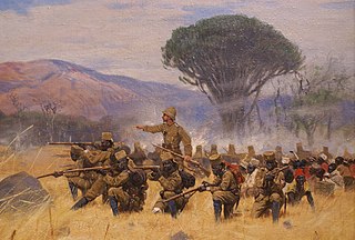
The Maji Maji Rebellion, was an armed rebellion of Africans against German colonial rule in German East Africa. The war was triggered by German colonial policies designed to force the indigenous population to grow cotton for export. The war lasted from 1905 to 1907, during which 75,000 to 300,000 died, overwhelmingly from famine. The end of the war was followed by a period of famine, known as the Great Hunger (ukame), caused in large part by the scorched-earth policies used by governor von Götzen to suppress the rebellion. These tactics have been described by scholars as genocidal. The name may have been the origin of the term for the 'Mau Mau rebellion' in Kenya five decades later.

Ruvuma Region is one of Tanzania's 31 administrative regions. The region covers a land area of 63,669 km2 (24,583 sq mi), comparable in size to the nation state of Latvia. The region is also bordered to the north by the Morogoro Region, to the northeast by the Lindi Region, to the east by the Mtwara Region,the west by Lake Nyasa with Malawi and to the northwest by the Njombe Region. The regional capital is the municipality of Songea.

Tabora is the capital of Tanzania's Tabora Region and is classified as a municipality by the Tanzanian government. It is also the administrative seat of Tabora Urban District. According to the 2012 census, the district had a population of 226,999.

Mtwara is the capital city of Mtwara Region in southeastern Tanzania. In the 1940s, it was planned and constructed as the export facility for the disastrous Tanganyika groundnut scheme, but was somewhat neglected when the scheme was abandoned in 1951. The city is spread out over a large area planned to accommodate up to 200,000 people. The present population is around 141,000. As part of the development associated with the failed Tanganyika groundnut scheme, Mtwara features a deep-water port that can accommodate ocean-going vessels, and a range of large municipal buildings, including a post office. Recent improvements in the port made it possible for big container ships to berth there.

Ilala District, officially the Ilala Municipal Council is one of five districts of the Dar es Salaam Region of Tanzania. The district is bordered to the north and northeast by Kinondoni District and Ubungo District, to the east by the Zanzibar Channel, the west by Pwani Region, and to the south by the Temeke District. It covers an area of 364.9 km2 (140.9 sq mi). The district is comparable in size to the land area of U.S Virgin Islands. The administrative seat is Mchafukoge. The 2022 National Tanzania Census states the population for Ilala as 1,649,912.
Nandyal, commonly called as Nandyala, is a city and the district headquarters of Nandyal district of the Indian state of the Andhra Pradesh. It is a Municipal corporation and the headquarters of Nandyal mandal in Nandyal revenue division.

Zanzibar City or Mjini District, often simply referred to as Zanzibar is one of two administrative districts of Mjini Magharibi Region in Tanzania. The district covers an area of 15.4 km2 (5.9 sq mi). The district is comparable in size to the land area of Nauru. The district has a water border to the west by the Indian Ocean. The district is bordered to the east by Magharibi District. The district seat is in Stonetown. The city is the largest on the island of Zanzibar. It is located on the west coast of Unguja, the main island of the Zanzibar Archipelago, north of the much larger city of Dar es Salaam across the Zanzibar Channel. The city also serves as the capital of the Zanzibar Urban/West Region. In 2022 its population was 219,007.

The following outline is provided as an overview of and topical guide to Tanzania:
Makambako is a medium-sized town and district in the Njombe Region of the Tanzanian Southern Highlands, located roughly 40 miles north of Njombe city by road. It is located at junction of the A104 and B4 roads between Njombe, Iringa, and Mbeya. Its population according to the 2002 Tanzanian census was 51,049.

The Mtwara–Mbamba Bay Road, also called the A19 Road, connects the city of Mtwara on the Indian Ocean coast, to the town of Mbamba Bay on the eastern coast of Lake Malawi. It is a busy and important transport corridor in the southern regions of Tanzania. It is also an integral part of the Mtwara Development Corridor that spans four Southern African countries; Malawi, Mozambique, Tanzania and Zambia.
Mfalikuivahaas are of chieftain bloodlines, 'Mfalmes', 'Chiefs', from Southern Africa at a time when Sub-Saharan African civilizations were rich in luxury products including incense, gold, ivory, and ebony. The name Mfalikuivahaa was better known when many areas in Africa were ruled through forms of governance that place power in the hands of a small, privileged ruling class of elders, leaders, and Shamans. Such a tribal assembly played an important role in the lives of many Africans contrasting as a form of governance to direct democracy today.

The Mtwara Development Project is a major infrastructure development project involving southern Tanzania, northern Mozambique, eastern Malawi and Eastern Zambia. The goal of this project is to provide road, rail and waterway access from the surrounding region to the Port of Mtwara. The region and the corridor has been neglected by the respective governments for over 40 years and the recent discovery of oil, gas and various minerals has kick started the development of the project. A road and rail link is to be built from the port of Mtwara to Mbamba Bay on Lake Nyasa to link Malawi to the corridor and further road links into Mozambique will facilitate access to northern Mozambique.
The Tanzanian Championship is the second tier of league football in Tanzania. The league is made up of sixteen teams that play thirty rounds, home and away.The league was formed in 1930.

Nanyamba Town, is a district established in 2016 of the Mtwara Region in the southern coastal Tanzania. Nanyamba is in the eastern portion of the Mtwara Region, near the coast.

John Chrisostom Ndimbo is a Tanzanian Catholic prelate who serves as the Bishop of the Roman Catholic Diocese of Mbinga. He was appointed bishop of Mbinga on 12 March 2011 by Pope Benedict XVI. From 8 April 2021 until 14 January 2024 he served as the Apostolic Administrator of the Roman Catholic Diocese of Njombe, at the direction of Pope Francis.


