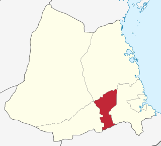
Ludewa District is one of six districts in the Njombe Region in Tanzania, East Africa. Prior to 2012, the district was one of the seven districts of Iringa Region. The town of Ludewa is the administrative seat of the district. A hospital is located in the city. The district is bordered to the north by the Njombe Rural District and Makete District, to the southeast by the Ruvuma Region and to the southwest by the country of Malawi across Lake Nyasa.

Matema is a town in southwestern Tanzania. The town is primarily a fishing village with some agriculture. It is located on the northern tip of Lake Nyasa and is 90 kilometres south-east of Mbeya.In 2016 the Tanzania National Bureau of Statistics report there were 10,304 people in the ward, from 17,103 in 2012.

Sengerema District is one of seven districts in the Mwanza Region of Tanzania, East Africa. Its administrative headquarter is located in Sengerema city. It is bordered to the north and east by Lake Victoria, to the south by Geita Region and to the southeast by the Misungwi District. Sengerema district is known for having numerous lake islands in its territory the largest are Maisome Island and Kome Island.
Ruangwa is one of six districts of the Lindi Region of Tanzania. It is bordered to the north by the Kilwa District, to the south by the Mtwara Region and to the west by the Nachingwea District.

Newala is one of the five districts of the Mtwara Region of Tanzania. It is bordered to the west by the Masasi District, to the east by the Tandahimba District, to the south by Newala Town, and to the north by the Tandahimba and Masasi Districts. The district is home the Miyuyu Forest Reserve.

Mtwara District is one of the five districts of the Mtwara Region of Tanzania. It is bordered to the south by Mozambique, to the west by the Tandahimba District, to the north by the Lindi Region and to the east by Mtwara-Mikindani District and the Indian Ocean.
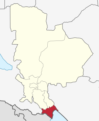
Kyela is one of the seven districts of Mbeya Region, Tanzania. It is bordered to the north by Rungwe District, to the northeast by Njombe Region, to the southeast by Lake Nyasa, to the south by Malawi and to the west by Ileje District.
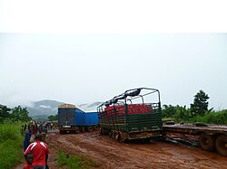
Ngonga is an administrative ward in the Kyela district of the Mbeya Region of Tanzania. The village is on Lake Nyasa by the Songwe River that forms the Tanzania and Malawi border, and thirty minute drive from the border crossing in Kasumulu. The ward covers an area of 339.4 square kilometres (131.0 sq mi) with an average elevation of 482 metres (1,581 ft).
Makuyuni is an administrative ward in the Monduli district of the Arusha Region of Tanzania. In 2016 the Tanzania National Bureau of Statistics report there were 12,529 people in the ward, from 11,228 in 2012.
Monduli Juu is an administrative ward in the Monduli District of the Arusha Region of Tanzania. In 2016 the Tanzania National Bureau of Statistics report there were 12,457 people in the ward, from 15,914 in 2012.
Mpalanga is an administrative ward in the Bahi District of the Dodoma Region of Tanzania. In 2016 the Tanzania National Bureau of Statistics report there were 11,116 people in the ward, from 10,228 in 2012.
Chemba is an administrative ward in the Chemba district of the Dodoma Region of Tanzania. In 2016 the Tanzania National Bureau of Statistics report there were 5,341 people in the district, from 16,047 in 2012.
Nyoni is a ward in Mbinga District the Ruvuma Region of the Tanzanian Southern Highlands. It is located along the A19 road.
Igongolo is a town and ward in Njombe district in the Iringa Region of the Tanzanian Southern Highlands. In 2016 the Tanzania National Bureau of Statistics report there were 8,720 people in the ward, from 8,447 in 2012.
Ikondo is a town and ward in Njombe district in the Njombe Region of the Tanzanian Southern Highlands. In 2016 the Tanzania National Bureau of Statistics report there were 7,163 people in the ward, from 6,312 in 2012.
Lupembe is a town and ward in Njombe Rural District in the Njombe Region of the Tanzanian Southern Highlands.

Nanyumbu is one of the six districts in the west of the Mtwara Region in southern Tanzania.

Mafinga Town Council is one of the five districts of the Iringa Region of Tanzania.

Mtwara Mikindani Municipal District Council is one of eight regional councils of the Mtwara Region in Tanzania. It is bordered to the north by the Lindi Region, to the east by the Indian Ocean and to the south and west by the Mtwara District. In 2016, the municipality has a total population of 113,732.
Katubuka is an administrative ward in Kigoma-Ujiji District of Kigoma Region in Tanzania. The ward covers an area of 3 km2 (1.2 sq mi), and has an average elevation of 814 m (2,671 ft). In 2016 the Tanzania National Bureau of Statistics report there were 27,287 people in the ward, from 24,790 in 2012.