
Dodoma Region is one of Tanzania's 31 administrative regions. The regional capital is the city of Dodoma. The region is located in central Tanzania, it is bordered by Singida Region to the west; Manyara Region to the north; Iringa Region to the south; and Morogoro Region to the east. Dodoma Region hosts the nation's capital city with where the legislative assembly or Bunge is based. Dodoma Region also hosts one of the largest University in Tanzania, University of Dodoma. The region is sole home of the Tanzanian wine industry, which is the second largest wine industry on the continent after South Africa. According to the 2022 national census, the region had a population of 3,085,625. 2012 national census, where by, 2012 had 2,083,588.

Pwani Region is one of Tanzania's 31 administrative regions. The word "Pwani" in Swahili means the "coast". The regional capital is the town of Kibaha. The Region borders the Tanga Region to the north, Morogoro Region to the west, Lindi Region to the south, and surrounds Dar es Salaam Region to the east. The Indian Ocean also borders the region to its northeast and southeast. The region is home to Mafia Island, the Rufiji delta and Saadani National Park. The region is home to Bagamoyo town, a historical Swahili settlement, and the first colonial capital of German East Africa. According to the 2012 national census, the region had a population of 1,098,668, which was slightly lower than the pre-census projection of 1,110,917. From 2002 to 2012, the region's 2.2 percent average annual population growth rate was the seventeenth-highest in the country. It was also the 21st most densely populated region with 34 people per square kilometre., According to the 2022 census the population had nearly doubled to 2,024,947. the region is slightly larger than Belgium.
Kilombero District is a district in Morogoro Region, south-western Tanzania.
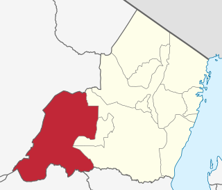
Morogoro Region is one of Tanzania's 31 administrative regions. The region covers an area of 70,624 km2 (27,268 sq mi). The region is comparable in size to the combined land area of the nation state of Ireland. Morogoro Region is bordered to the north by the Manyara Region and Tanga Region, to the east by the Pwani and Lindi Regions, to the south by the Ruvuma Region and to the west by the Iringa Njombe and Dodoma Regions. The regional capital is the municipality of Morogoro. According to the 2022 national census, the region had a population of 3,197,104.
Nzega District is one of the seven districts of the Tabora Region of Tanzania. It is bordered to the north by Shinyanga Region, to the south and southwest by Uyui District and to the east by Igunga District. Its administrative seat is the town of Nzega.
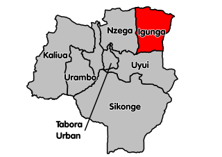
Igunga is one of the seven districts of the Tabora Region of Tanzania. It is bordered to the north by the Shinyanga Region, to the east by the Singida Region, to the south by the Uyui District and to the west by the Nzega District. Its administrative seat is the town of Igunga. Igunga is now divided by two Constituencys: Igunga Constituency and Manonga Constituency, whereby Manonga town is Choma Chankola. Igunga is the second district in production
Kilindi is one of eleven administrative districts of Tanga Region in Tanzania. The District covers an area of 6,444 km2 (2,488 sq mi). It is bordered to the east by the Handeni District and Handeni Town Council, to the south west by the Kiteto District and north west by the Simanjiro District of Manyara Region. Kilindi District is bordered to the south by Gairo District and Kilosa District of Morogoro Region. The district created from Handeni District in 2002. The district seat (capital) is the town of Songe. According to the 2022 census, the district has a total population of 398,391.

Liwale is one of the six districts of the Lindi Region of Tanzania. It is the largest district in Lindi and one of the largest in districts in Tanzania. It is bordered to the north by the Pwani Region, to the east by the Kilwa District, to the south by the Ruangwa District and to the west by the Morogoro Region. Most of Liwale district is within the Nyerere National Park.
Kilolo is one of the four districts of the Iringa Region of Tanzania. It is bordered to the north and east by the Morogoro Region, to the south by Mufindi District and to the west by the Iringa Rural District. The district is home to the Udzungwa Mountains National Park.

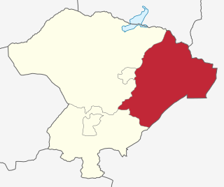
Kilosa District is one of the six districts of the Morogoro Region of Tanzania. Its administrative seat is the town of Kilosa. Kilosa District covers 14,918 square kilometres (5,760 sq mi). It is bordered to the north by the Manyara Region, to the northeast by the Tanga Region, to the east by Mvomero District, to the southeast by Morogoro Rural District, to the south by Kilombero District, to the southwest by the Iringa Region and to the west by the Dodoma Region. Kilosa District is home to Mikumi National Park.

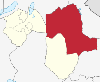
Morogoro Rural District is one of the six districts of the Morogoro Region of Tanzania. Morogoro Rural District covers 19,056 square kilometres (7,358 sq mi). It is bordered to the north and east by the Pwani Region, to the south by Kilombero District, to the southwest by the Kilosa District and to the west by the Mvomero District and the Morogoro Urban District.

Kongwa District is one of the seven districts of the Dodoma Region of Tanzania. It is bordered to the north by Manyara Region, to the east by Morogoro Region, to the south by Mpwapwa District, and to the west by Chamwino District. Its district capital is the town of Kongwa.

Songea Rural District is one of five districts in the Ruvuma Region of Tanzania. It is bordered to the north by the Morogoro Region, to the east by the Namtumbo District, to the south by the Songea Urban District, to the west by the Mbinga District and to the Northwest by the Iringa Region.
Simanjiro District is one of the six districts of the Manyara Region of Tanzania. It is bordered to the north by Arusha Region, to the north east by Kilimanjaro Region, to the south east by Tanga Region, to the south by Kiteto District, to the south west by Dodoma Region and to the west by Babati Rural District. The district headquarters are located in Orkesumet. According to the 2022 Tanzania National Census, the population of Simanjro District was 291,169. Simanjiro District is endowed with gemstones, being the only location on the planet that has tanzanite. Simanjiro was also where the first tsavolite was discovered.

Manyoni District is one of the six districts in the Singida Region of Tanzania. The district capital is the town of Manyoni. The district is bordered to the north by the Ikungi District, to the east by the Dodoma Region, to the south by the Iringa Region, to the southwest by the Mbeya Region and to the west by the Tabora Region. In 2015 the Itigi District was created from the Manyoni District, separating the Itigi Division that was the large portion of the south western of the district.
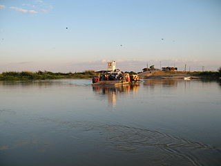
Mlimba is a town in central Tanzania on the plains.

Mpwapwa District is one of the seven districts of the Dodoma Region of Tanzania. It is bordered to the north by Kongwa District, to the east by Morogoro Region, to the south by Iringa Region, and to the west by Chamwino District. Its district capital is the town of Mpwapwa.
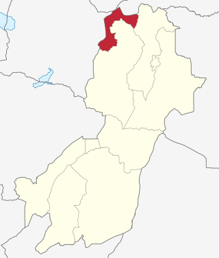
Gairo District is one of the seven districts of the Morogoro Region of Tanzania. It is located in the northwest corner of Morogoro Region. The administrative seat is in the town of Gairo. According to the 2022 Tanzania National Census, the population of Gairo District was 258,205 in 2022.

Morogoro Urban District is one of the six districts of the Morogoro Region of Tanzania. It contains the city Morogoro, capital of the Morogoro Region, and no villages. Morogoro Urban District covers 260 square kilometres (100 sq mi). It is bordered to the east and south by the Morogoro Rural District and to the north and west by Mvomero District

Chalinze District Council is one of nine administrative districts of Pwani Region in Tanzania. The district covers an area of 8,042 km2 (3,105 sq mi). The district is comparable in size to the land area of Puerto Rico. Chalinze District is bordered to the northeast by Pangani District, the north by Handeni District and in Kilindi District of Tanga Region. The district is bordered to the east by the Indian Ocean. Chalinze is also borders Bagamoyo District, Kibaha Urban District and to the South by Kibaha District. On the western part, the district is bordered by Mvomero District and Morogoro Rural District of Morogoro Region.
