This article is about the Transport in Zambia.

Ndola is the third largest city in Zambia and third in terms of size and population, with a population of 475,194, after the capital, Lusaka, and Kitwe, and the second largest in terms of infrastructure development after Lusaka. It is the industrial and commercial center of the Copperbelt, Zambia's copper-mining region, and capital of Copperbelt Province. It lies just 10 kilometres (6.2 mi) from the border with DR Congo. It is also home to Zambia's first modern stadium, the Levy Mwanawasa Stadium.

The Tazara Railway, also called the Uhuru Railway or the Tanzam Railway, is a railway in East Africa linking the port of Dar es Salaam in east Tanzania with the town of Kapiri Mposhi in Zambia's Central Province. The single-track railway is 1,860 km (1,160 mi) long and is operated by the Tanzania-Zambia Railway Authority (TAZARA).

Zambia Railways (ZR) is the national railway company of Zambia, one of the two major railway organisations in Zambia. The other system is the binational TAZARA Railway (TAZARA) that interconnects with the ZR at Kapiri Mposhi and provides a link to the Tanzanian port of Dar es Salaam.

The Walvis Bay-Ndola-Lubumbashi Development Road runs from Walvis Bay, through Rundu in north eastern Namibia, along the Caprivi Strip to Katima Mulilo on the Zambezi River, which forms the border between Namibia and Zambia. The Katima Mulilo Bridge spans the river to the Zambian town of Sesheke from where a road runs to Livingstone, joining the main north–south highway to Lusaka, connecting onwards to the Copperbelt.

The Great North Road is a major route in Zambia, running north from Lusaka through Kabwe, Kapiri Mposhi, Serenje, Mpika, Isoka and Nakonde to the border with Tanzania. The entire route is designated as the T2 road on Zambia's road network. It forms the Zambian section of the Tanzam Highway.

Mpika is a town in the Muchinga Province of Zambia, lying at the junction of the M1 Road to Kasama and Mbala and the Tanzam Highway to Dar es Salaam, Tanzania in the north-east and Lusaka in the south-west. It also has a railway station on the TAZARA Railway about 5 kilometres (3 mi) away. Mpika is situated between the Muchinga Escarpment to the east and vast miombo plains to the west. The town has an estimated population of 40,000 inhabitants (2008), while the district population is estimated at 150,000 inhabitants. Since Mpika District was the biggest district in Zambia before its division in 2017, the population density was less than 4 people per square kilometre.
Rail transport in Zambia is primarily provided by two systems:

The Congo Pedicle road crosses the Congolese territory of the Congo Pedicle and was constructed by and is maintained by Zambia to connect its Copperbelt and Luapula Provinces. Both the road and the territory may be referred to as ‘the Pedicle’. It is designated as the N36 Route on the Congolese Road Network.
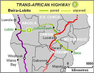
The Beira–Lobito Highway or TAH 9 is Trans-African Highway 9 in the transcontinental road network being developed by the United Nations Economic Commission for Africa (UNECA), the African Development Bank (ADB), and the African Union. The route has a length of 3,523 km (2,189 mi) crossing Angola, the most southerly part of the Democratic Republic of the Congo, Zambia, Zimbabwe, and central Mozambique.

Muchinga Province is one of the ten provinces of Zambia. It is located in the northeast of the country and borders with Tanzania in the north, Malawi in the east, Eastern Province in the south, Central Province in the southwest, Luapula Province in the west, and Northern Province in the northwest. The administrative center of the province is Chinsali.
Chilonga is a town in Mpika District in the Muchinga Province of Zambia.
Nakonde is a town in the Muchinga Province of Zambia, on the border with Tanzania. It is at the northern end of Zambia's Great North Road. It is the principal commercial and political headquarters of Nakonde District and the district headquarters are located here.

The T2 is a trunk road in Zambia. The road runs from the Tunduma border with Tanzania via Mpika, Kabwe and Lusaka to the Chirundu border with Zimbabwe. The road is the longest route of the country, as it is approximately 1,155 kilometres (718 mi). The route from Mpika to Kafue is a toll road. The route from Tanzania to Lusaka is Zambia's Great North Road and is part of the Tanzam Highway.
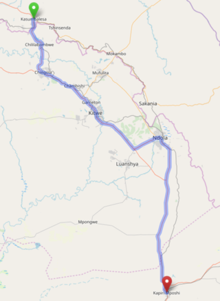
The T3 is a trunk road in Zambia. The road runs from Kapiri Mposhi via Ndola, Kitwe and Chingola to Kasumbalesa on the border with DR Congo. The entire route is a toll road.

The Tanzam Highway leads from Lusaka in Zambia to Dar es Salaam in Tanzania. The highway was built from 1968 to 1973 in several stages and was intended to provide seaport access for Zambia and to expand the transport options for Zambia, Malawi and the then Zaire.
The M4 road is a road in the Copperbelt Province of Zambia. The road connects the city of Ndola with the city of Mufulira and extends to connect Mufulira with the city of Kitwe. As it is a v-shaped route, the M4 road starts and ends at a junction with the T3 road.
The M1 road is a road in northern Zambia. It connects Mpika in Muchinga Province with Mbala in the Northern Province on the border with Tanzania and the Lake Tanganyika port of Mpulungu via Kasama. The northern section is a toll road.


