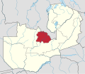
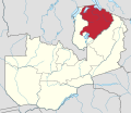
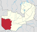
Provinces of Zambia

Last updated

Zambian Provinces
Zambia, administrative divisions - en - monochrome.svg
Category Unitary state
Location Zambia
Number10 Provinces
Populations711,657 (Muchinga) – 2,191,225 (Lusaka)
Areas8,454 sq mi (21,896 km2) (Lusaka) – 48,798 sq mi (126,386 km2) (Western)
Government
Subdivisions

Zambia is divided into 10 provinces for administrative purposes. Each province is headed by a minister appointed by the President and there are ministries of central government for each province. The administrative head of each province is the Permanent Secretary, appointed by the President. There are Deputy Permanent Secretary, heads of government departments and civil servants at the provincial level.[ citation needed ]

Contents

Provinces are further divided into districts and almost all the district headquarters are the same as the district names. Each of the 116 districts in the 10 provinces has a council which is headed by an elected representative, called councilor. Each councilor holds office for five years. Each council is responsible for raising and collecting local taxes and the budgets of the council are audited and submitted every year after the annual budget. Zambia has predominantly rural provinces and hence there are only four municipal councils. The government stipulates 63 different functions for the councils with the majority of them being infrastructure management and local administration.[ citation needed ]

Western Province is the largest in terms of area, having 126,386 square kilometres (48,798 sq mi), while Lusaka is the smallest with 21,896 square kilometres (8,454 sq mi). In terms of population, Lusaka is the most populated and most densely populated with a population of 2,191,225 and density of 100 persons per square kilometre.

Agriculture is the major profession in most of the provinces in Zambia. Maize, mixed beans, rice, sorghum, soya beans, sunflower, sweet potatoes and wheat are the major crops in the provinces. Among all provinces, Central has the maximum area of 391,593.23 ha (967,647.9 acres) constituting 20.64 per cent of the totals, while Luapula has the smallest area at 3.06 per cent.[ citation needed ]

List of provinces

Province [1] CapitalArea (km2)Population (2018)Density
(people/km2)
DistrictsMap
Central [2] Kabwe 110,4501,743,99915.811
Central in Zambia.svg
Copperbelt [3] Ndola 31,3282,642,13281.210
Copperbelt in Zambia.svg
Eastern Chipata 98,8771,961,26938.115
Eastern in Zambia.svg
Luapula Mansa 50,5671,215,29424.012
Luapula in Zambia.svg
Lusaka [2] Lusaka 23,4903,186,336135.66
Lusaka in Zambia.svg
Muchinga [4] Chinsali [5] 70,4051,011,65511.58
Muchinga in Zambia.svg
North-Western Solwezi 125,826902,6317.211
North-Western in Zambia.svg
Northern Kasama 77,6501,430,54318.412
Northern in Zambia.svg
Southern Choma 68,4101,852,36127.115
Southern in Zambia.svg
Western [3] Mongu 126,3861,041,5008.216
Western in Zambia.svg
ZambiaLusaka752,61213,092,66617.3116

Administration

Provincial government is set up purely for administrative purposes. Each province is headed by a minister appointed by the President and there are ministries of central government for each province. The administrative head of each province is the Permanent Secretary, appointed by the President. There are Deputy Permanent Secretary, heads of government departments and civil servants at the provincial level. Provinces are further divided into districts and almost all the district headquarters are the same as the district names. Each of the 116 districts in the 10 provinces has a council which is headed by an elected representative, called councilor. Each councilor holds office for three years. [6] The administrative staff of the council is selected based on Local Government Service Commission from within or outside the district. The office of the provincial government is located in each of the district headquarters and has provincial local government officers and auditors. Each council is responsible for raising and collecting local taxes and the budgets of the council are audited and submitted every year after the annual budget. The elected members of the council do not draw salaries, but are paid allowances from the council. Zambia has predominantly rural provinces and hence there are only four city councils (Lusaka; Ndola; Kitwe; Chipata) as of 2017. The government stipulates 63 different functions for the councils with the majority of them being infrastructure management and local administration. Councils are mandated to maintain each of their community centres, zoos, local parks, drainage system, playgrounds, cemeteries, caravan sites, libraries, museums and art galleries. They also work along with specific government departments for helping in agriculture, conservation of natural resources, postal service, establishing and maintaining hospitals, schools and colleges. The councils prepare schemes that encourage community participation. [7]

Primary data

Western Province is the largest in terms of area, having 126,386 km2, while Lusaka was the smallest with 21,896 km2. In terms of population, Lusaka is the most populated and most densely populated with a population of 2,191,225 and densf 100 persons per km2. As of 2010, Western Province had the best sex ratio of 108 females for every 100 males, while Copperbelt had the lowest of 101. Northern had the highest number of basic schools, while Copperbelt had the highest number of high schools. The unemployment rate of youth (55%) and general unemployment rate (32%) was the highest in Copperbelt province, while Eastern had the lowest unemployment rate of 6 per cent. AIDS death was maximum in Copperbelt with 26,799 recorded deaths in 2010, while it was lowest in North-Western with 2,859 recorded deaths. Lusaka Province had the most doctors and fewest malaria related incidents, while North-Western has the lowest number of doctors. [8] [9] [10] [11] [12] [13] [14] [15] [16] [17]

Primary data of Zambia Provinces
ParameterYear Central [8] Copperbelt [12] Eastern [16] Luapula [9] Lusaka [13] Muchinga Province [10] Northern [17] North-Western [14] Southern [11] Western [15]
CapitalKabweNdolaChipataMansaLusakaChinsaliKasamaSolweziChomaMongu
Provincial Minister 2022Hon. Credo Nanjuwa [18] Hon. Elisha Matambo [18] Hon. Peter Phiri [18] Hon. Derricky ChilundikaHon. Sheal Mulyata [18] Hon. Henry Sikazwe [18] Hon. Leonard Mbao [18] Hon. Robert Lihefu [18] Hon. Cornelius Mweetwa [18] Hon. Kapelwa Mbangweta [18]
Land area, km294,39431,32851,47650,56721,89687,80677,650125,82685,283126,386
Population, persons20101,307,1111,972,3171,592,661991,9272,191,225711,6571,105,824727,0441,589,926902,974
Population density, people per km22010014063031020100008014006019007
Sex Ratio (females per 100 males)2010102101103103102103102103104108
Basic Schools2004653856861527502No data1,208536995648
High Schools2004028071041020039No data026023045026
Out of School Children Aged 7–15200433,08114,332132,72858,88790,620No data22,34826,83430,39036,984
Unemployment rate (%)2008009032006006031No data007014007010
Unemployment rate, Youth (%)2008018055012014052No data012031006018
Doctors2005035213036030231No data040025050046
Malaria Incidence rate per 1,000 population2005331377447407313No data331439344430
AIDS Deaths20109,01626,7999,3385,20915,429No data6,9582,85912,4036,044

Economy

Agriculture is the major profession in most of the provinces in Zambia. Maize, mixed beans, rice, sorghum, soya beans, sunflower, sweet potatoes and wheat are the major crops in the provinces. Among all provinces, Central had the maximum area, 391,593.23 ha (967,647.9 acres), constituting 20.64 per cent of the total, while Luapula had the smallest area at 3.06 per cent. Maize production was maximum in Eastern (22.5%), mixed beans (51.66%) in Northern, sorghum in Southern (40.62%), sunflower in Eastern (70.2%), soya beans (45.06%), sweet potatoes (28.5%) and wheat (49.51%) in Central Province. [19]

Agriculture data of Zambia Provinces in 2014 [19]
Paramaeter Central Copperbelt Eastern Luapula Lusaka Muchinga Province Northern North-Western Southern Western
Area Planted (HA)391,593.23122,525.52387,273.0957,966.3182,603.72112,345.23191,104.5679,528.80360,160.32112,153.47
Maize Production723,760.85235,415.71745,580.30131,746.91148,290.62244,978.50283,755.88160,866.33597,999.4178,276.86
Mixed Beans Production5,316.431,213.882,794.774,130.48673.809,277.3331,898.084,446.711,685.30312.13
Rice Production017.85004.24900.372,254.43036.536,928.6318,169.24445.61021.2220,861.51
Sorghum Production452.85587.45200.49105.83320.213,118.55283.551,038.134,694.90755.44
Soya Beans Production96,518.0337,609.8617,534.11430.0032,237.442,245.704,742.11579.6722,203.88077.92
Sun Flower Production2,872.09028.6724,053.17005.58049.21432.17764.17014.866,042.08001.66
Sweet Potatoes Production42,787.8511,603.637,842.7411,356.024,689.7218,151.3411,636.018,200.7631,048.672,841.24
Wheat Production99,758.2728,690.00120.00000.0048,509.73000.00000.00000.0024,426.13000.00
Grand Total971,484.23315,153.44799,025.94150,029.26234,807.26285,132.23351,249.04175,592.09688,121.60103,126.75

Human Development

This is a list of 9 provinces by Human Development Index as of 2017. [20]

Medium Human Development
RankProvince2017 HDI
1 Lusaka 0.672
2 Copperbelt 0.670
3 Southern 0.590
-Flag of Zambia.svg  Zambia (average)0.589
4 Central 0.572
5 North-Western 0.564
Low Human Development
6 Northern 0.538
7 Western 0.531
8 Luapula 0.528
9 Eastern 0.507

See also

Related Research Articles

<span class="mw-page-title-main">Zambia</span> Country at the crossroads of Central and Southern Africa

Zambia, officially the Republic of Zambia, is a landlocked country at the crossroads of Central, Southern and East Africa. Its neighbours are the Democratic Republic of the Congo to the north, Tanzania to the north-east, Malawi to the east, Mozambique to the southeast, Zimbabwe and Botswana to the south, Namibia to the southwest, and Angola to the west. The capital city of Zambia is Lusaka, located in the south-central part of Zambia. The population is concentrated mainly around Lusaka in the south and the Copperbelt Province to the north, the core economic hubs of the country.

<span class="mw-page-title-main">Copperbelt Province</span> Province of Zambia

Copperbelt Province is a province in Zambia which covers the mineral-rich Copperbelt, and farming and bush areas to the south. It was the backbone of the Northern Rhodesian economy during British colonial rule and fuelled the hopes of the immediate post-independence period, but its economic importance was severely damaged by a crash in global copper prices in 1973. The province adjoins the Haut-Katanga province of the Democratic Republic of the Congo, which is similarly mineral-rich.

<span class="mw-page-title-main">Western Province, Zambia</span> Province of Zambia

Western Province is one of the 10 provinces in Zambia and encompasses most of the area formerly known as Barotseland. The capital is Mongu, and together with the neighbouring town of Limulunga, Mongu is treated as the capital of Barotseland.

<span class="mw-page-title-main">Northern Province, Zambia</span> Province of Zambia

Northern Province is one of Zambia's ten provinces. It covers approximately one sixth of Zambia in land area. The provincial capital is Kasama. The province is made up of 12 districts, namely Kasama District, Chilubi District, Kaputa District, Luwingu District, Mbala District, Mporokoso District, Mpulungu District, Mungwi District, Nsama District, Lupososhi District, Lunte District and Senga Hill District. Currently, only Kasama and Mbala have attained municipal council status, while the rest are still district councils. It is widely considered to be the heartland of the Bemba, one of the largest tribes in Zambia.

<span class="mw-page-title-main">Central Province, Zambia</span> Province of Zambia

Central Province is one of Zambia's ten provinces. The provincial capital is Kabwe, which is the home of the Mulungushi Rock of Authority. Central Province has an area of 94,394 km (58,654 mi). It borders eight other provinces and has eleven districts. The total area of forest in the province is 9,095,566 ha, and it has a national park and three game management areas. The first mine in the region was opened up in 1905 making the then Broken Hill town the first mining town. In 1966, he town's name was reverted to its indigenous name - Kabwe meaning 'ore' or 'smelting'.

<span class="mw-page-title-main">Eastern Province, Zambia</span> Province of Zambia

Eastern Province is one of Zambia's ten provinces. The province lies between the Luangwa River and borders with Malawi to the east and Mozambique to the south, from Isoka in the northeast to the north of Luangwa in the south. The provincial capital is Chipata. Eastern province has an area of 51,476 km2 (19,875 sq mi), locally shares border with three other provinces of the country and is divided into fifteen districts.

<span class="mw-page-title-main">Luapula Province</span> Province of Zambia

Luapula Province is one of Zambia's ten provinces located in the northern part of the country. Luapula Province is named after the Luapula River and its capital is Mansa. As per the 2010 Zambian census, the Province had a population of 991,927, which accounted for 7.57 per cent of the total Zambian population.

<span class="mw-page-title-main">Lusaka Province</span> Province of Zambia

Lusaka Province is one of the ten provinces of Zambia. Its capital is Lusaka, which is also the national capital. It is the smallest province in Zambia, with an area of 21,896 km2. Lusaka is also Zambia's most populated and most densely populated province, with a population of 2,191,225 and density of 100 persons per km2 as of 2010. It is the most urban province, with the most doctors and fewest malaria-related incidents. The province is bordered by Zimbabwe and Mozambique, and separated by the Lower Zambezi National Park.

<span class="mw-page-title-main">Southern Province, Zambia</span> Province of Zambia

Southern Province is one of Zambia's ten provinces, and home to Zambia's premier tourist attraction, Mosi-oa-Tunya, shared with Zimbabwe. The centre of the province, the Southern Plateau, has the largest area of commercial farmland of any Zambian province, and produces most of the maize crop.

<span class="mw-page-title-main">North-Western Province, Zambia</span> Province of Zambia

North-Western Province is one of ten Provinces of Zambia. It covers an area of 125,826 km2 (48,582 sq mi), has a population of 727,044 and a population density of 5.80 per square kilometre as of 2010. It is the most sparsely populated province in the country. The provincial capital is Solwezi. The literacy rate stood at 63 per cent against a national average of 70.2 per cent. The rural population constituted 77.45%, while the urban population was 22.55%. North-Western Province is bordered along Angola in the west, the Democratic Republic of Congo in the north, Copperbelt Province in the east, Central in the south-east, and Western Province in the south-west.

<span class="mw-page-title-main">Districts of Zambia</span>

The ten provinces of Zambia are divided into a total of 116 districts as of 2018.

<span class="mw-page-title-main">Languages of Zambia</span> Dialects of the southern African country

Zambia has several major indigenous languages, all members of the Bantu family, as well as Khwedam, Zambian Sign Language, several immigrant languages and the pidgins Settla and Fanagalo. English is the official language and the major language of business and education.

<span class="mw-page-title-main">Outline of Zambia</span> Overview of and topical guide to Zambia

The following outline is provided as an overview of and topical guide to Zambia:

HIV/AIDS is considered the deadliest epidemic in the 21st century. It is transmitted through sex, intravenous drug use and mother-to-child transmission. Zambia is experiencing a generalized HIV/AIDS epidemic, with a national HIV prevalence rate of 11.3% among adults ages 15 to 49 as of 2018. Per the 2000 Zambian census, the people affected by HIV/AIDS constituted 15% of the total population, amounting to one million, of which 60% were women. The pandemic results in increased number of orphans, with an estimated 600,000 orphans in the country. It was prevalent more in urban areas compared to rural and among all provinces, Copperbelt Province and Lusaka Province had higher occurrence.

The 2000 Zambian census was conducted in Zambia in 2000 by DRS under approval of the Government of Zambia, which recorded demographic data from 13 million people and 4 million households. Planning for the project commenced in 1998. In October 2000 the census started, with more than 30,000 workers across Zambia completing the 17 million double-sided A4 forms. The census was completed in May 2001. The scanning was undertaken in collaboration with the Examinations Council of Zambia (ECZ) and published by the Central Statistical Office. The census was noted by the Milton Keynes & North Bucks Chamber of Commerce and the DRS received a special commendation for its census work in Africa.

<span class="mw-page-title-main">Chilanga (Lusaka), Zambia</span> Township of Lusaka, Zambia

Chilanga is a township located 20 km south of Zambia's capital city, Lusaka. It is situated midway between Lusaka and Kafue on the T2 road.

<span class="mw-page-title-main">Lusaka</span> Capital of Zambia

Lusaka is the capital and largest city of Zambia. It is one of the fastest-developing cities in southern Africa. Lusaka is in the southern part of the central plateau at an elevation of about 1,279 metres (4,196 ft). As of 2019, the city's population was about 3.3 million, while the urban population is estimated at 2.5 million in 2018. Lusaka is the centre of both commerce and government in Zambia and connects to the country's four main highways heading north, south, east, and west. English is the official language of the city administration, while Bemba, Tonga, Lenje, Soli, Lozi, and Nyanja are the commonly spoken street languages.

<span class="mw-page-title-main">Subdivisions of Zambia</span>

Zambia is divided into ten provinces, each administered by an appointed deputy minister. Each province is divided into several districts with a total of 116 districts. The provinces are:

<span class="mw-page-title-main">Muchinga Province</span> Province of Zambia

Muchinga Province is one of the ten provinces of Zambia. It is located in the northeast of the country and borders with Tanzania in the north, Malawi in the east, Eastern Province in the south, Central Province in the southwest, Luapula Province in the west, and Northern Province in the northwest. The administrative center of the province is Chinsali.

The 2010 Zambian census was conducted in Zambia in 2010 under the approval of the Government of Zambia, which recorded demographic data from 13 million people and 3.2 million households. The 2010 Census of Population and Housing was conducted between 16 October and 15 November 2010, with all parts of the country covered by 30 November 2010. It was the fifth national population census exercise of Zambia since its independence in 1964, with the previous censuses conducted in 1969, 1980, 1990 and 2000. A total of 3.2 million questionnaires were used for data collection and the processing started in April 2011 by the Central Statistical Office. Optical Mark Reading (OMR) and Intelligent Character Recognition (ICR) technology were used for data capture. The census was funded by United Nations Population Fund (UNFPA), the United Kingdom AID, the United States Agency for International Development (USAID) and the African Development Bank (AfDB), who contributed close to 60 per cent of the total expenditure and rest contributed by the Ministry of Finance of the Government of Zambia.

References

  1. Gwillim Law. "Zambia Provinces" . Retrieved 18 June 2015. (Population figures are from the census of 2010).
  2. 1 2 Lusaka province was split from Central province in 1973. Initially Lusaka province was only 360 km², but by 1988 it had been enlarged to its present size.
  3. 1 2 The Copperbelt province was known as Western Province until 1969. At the same time the name of the Barotseland province was changed to Western province.
  4. Created on November 2011, consisting 5 districts from Northern Province and one from Eastern.
  5. Zambia's 10th Province, Muchinga, Ministry of Local Government and Housing, Zambia Archived 2014-01-18 at the Wayback Machine
  6. Zambi Public administration Country profile (PDF) (Report). Division for Public Administration and Development Management (DPADM), Department of Economic and Social Affairs (DESA), United Nations. 2004. p. 7. Retrieved 16 October 2016.
  7. The local government system in Zambia (PDF) (Report). Common Wealth Local Government Forum. pp. 218–220. Retrieved 16 October 2016.
  8. 1 2 "Primary Data of Central Province". Zambia data portal, Central statistical Office of Zambia. 2011. Retrieved 16 October 2016.
  9. 1 2 "Primary Data of Lauapula Province". Zambia data portal, Central statistical Office of Zambia. 2011. Retrieved 16 October 2016.
  10. 1 2 "Primary Data of Muchinga Province". Zambia data portal, Central statistical Office of Zambia. 2011. Retrieved 16 October 2016.
  11. 1 2 "Primary Data of Southern Province". Zambia data portal, Central statistical Office of Zambia. 2011. Retrieved 16 October 2016.
  12. 1 2 "Primary Data of Copperbelt Province". Zambia data portal, Central statistical Office of Zambia. 2011. Retrieved 16 October 2016.
  13. 1 2 "Primary Data of Lusaka Province". Zambia data portal, Central statistical Office of Zambia. 2011. Retrieved 16 October 2016.
  14. 1 2 "Primary Data of North-Western Province". Zambia data portal, Central statistical Office of Zambia. 2011. Retrieved 16 October 2016.
  15. 1 2 "Primary Data of Western Province". Zambia data portal, Central statistical Office of Zambia. 2011. Retrieved 16 October 2016.
  16. 1 2 "Primary Data of Eastern Province". Zambia data portal, Central statistical Office of Zambia. 2011. Retrieved 16 October 2016.
  17. 1 2 "Primary Data of Northern Province". Zambia data portal, Central statistical Office of Zambia. 2011. Retrieved 16 October 2016.
  18. 1 2 3 4 5 6 7 8 9 "Provincial Ministers | National Assembly of Zambia". www.parliament.gov.zm. Retrieved 29 August 2022.
  19. 1 2 "Agriculture statistics of Zambia 2014". Central Statistical Office of Zambia. 2016. Retrieved 17 October 2016.
  20. "Sub-national HDI – Area Database – Global Data Lab". hdi.globaldatalab.org. Retrieved 13 September 2018.