Mulobezi District is a district of Zambia, located in Western Province. It was separated from Sesheke District in 2013. As of the 2022 Zambian Census, the district had a population of 45,326 people.

Luano District is a district of Central Province, Zambia. It was separated from Mkushi District in 2012. As of the 2022 Zambian Census, the district had a population of 66,679 people.

Ngabwe District is a district of Central Province, Zambia. It was separated from Kapiri Mposhi District in 2012. As of the 2022 Zambian Census, the district had a population of 42,104 people.
Mwansabombwe District is a district of Luapula Province, Zambia. The seat of the district is Mwansabombwe. It was separated from Kawambwa District in 2012. As of the 2022 Zambian Census, the district had a population of 58,919 people.

Chilanga District is a district of Lusaka Province, Zambia. The capital of the district is Chilanga. It was separated from Kafue District in 2012. As of the 2022 Zambian Census, the district had a population of 225,276 people.

Shibuyunji District, also known as Sibuyunji District, is a district of Central Province, Zambia. As of the 2022 Zambian Census, the district had a population of 91,616 people.
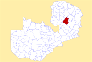
Kanchibiya District is a district of Muchinga Province, Zambia. It was separated from Mpika District in 2017. As of the 2022 Zambian Census, the district had a population of 93,052 people.

Lavushimanda District is a district of Muchinga Province, Zambia. It was named after the Lavushi Manda National Park and separated from Mpika District in 2017. It also contains a town centre of the same name on the Great North Road. As of the 2022 Zambian Census, the district had a population of 55,755 people.

Lunte District is a district of Northern Province, Zambia. It was separated from Mporokoso District in 2017. As of the 2022 Zambian Census, the district had a population of 84,573 people.

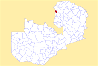
Kalumbila District is a district of North-Western Province, Zambia. It was named after a mine of the same name and was made independent from Solwezi District In 2016. As of the 2022 Zambian Census, the district had a population of 177,067 people.

Manyinga District is a district of North-Western Province, Zambia. It was separated from Kabompo District in 2012. As of the 2022 Zambian Census, the district had a population of 75,030 people.

Mushindamo District is a district of North-Western Province, Zambia. It was created from part of Solwezi District in 2016. However, as of 2021, it is not clear where the Mushindamo Central Business District is to be located.

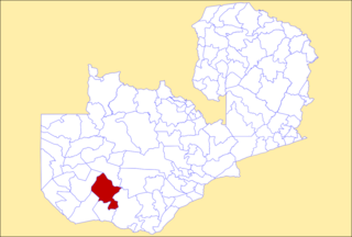
Chikankata District is a district of Southern Province, Zambia. It was separated from Mazabuka District in December 2011. As of the 2022 Zambian Census, the district had a population of 98,671 people.

Nkeyema District is a district of Western Province, Zambia. It was separated from Kaoma District in 2012. As of the 2022 Zambian Census, the district had a population of 106,074 people.

Chasefu District is a district of Eastern Province, Zambia. It was made independent from Lundazi District in 2018. As of the 2022 Zambian Census, the district had a population of 131,160 people.

Lupososhi District is a district of Northern Province, Zambia. It was created in 2018 by splitting Luwingu District. As of the 2022 Zambian Census, the district had a population of 79,614 people.

Chifunabuli District is a district of Luapula Province, Zambia. It was created in 2018 by splitting Samfya District. As of the 2022 Zambian Census, the district had a population of 116,326 people.

Lumezi District is a district of Eastern Province, Zambia. It was made independent from Lundazi District in 2018. As of the 2022 Zambian Census, the district had a population of 158,971 people.

Chipangali District is a district of Eastern Province, Zambia. It was made independent from Chipata District in 2018. As of the 2022 Zambian Census, the district had a population of 169,357 people.

Lusangazi District is a district of Eastern Province, Zambia. It was made independent from Petauke District in 2018. As of the 2022 Zambian Census, the district had a population of 110,523 people.
