
Northern Province is one of Zambia's ten provinces. It covers approximately one-sixth of Zambia in land area. The provincial capital is Kasama. The province is made up of 12 districts, namely Kasama District, Chilubi District, Kaputa District, Luwingu District, Mbala District, Mporokoso District, Mpulungu District, Mungwi District, Nsama District, Lupososhi District, Lunte District and Senga Hill District. Currently, only Kasama and Mbala have attained municipal council status, while the rest are still district councils. It is widely considered to be the heartland of the Bemba, one of the largest tribes in Zambia.

Luapula Province is one of Zambia's ten provinces located in the northern part of the country. Luapula Province is named after the Luapula River and its capital is Mansa. As per the 2022 Zambian census, the Province had a population of 1,519,478, which accounted for 7.72 per cent of the total Zambian population.
Milenge District with headquarters at Milenge, Zambia is the most southerly district in the Luapula Province and was carved out of Mansa District. As of the 2022 Zambian Census, the district had a population of 56,543 people. It is rural and undeveloped, lacking roads and infrastructure. Its southern boundary is the Luapula River which divides it from DR Congo and the district lies roughly between the Chembe Ferry to Mansa road in the west and the Kapalala Ferry to Samfya road in the east. A single dirt road runs through the central part of the district from Chembe in the west following the north-west bank of the Lwela River, passing through Milenge Boma, Milambo and Lwela Mission, eventually connecting to the provincial capital, Mansa in the north-west. Most of the population of the district lives along the shallow valley of the Lwela River. The district is gently undulating flat plateau with an elevation of about 1200 m, consisting of woodland and wooded grassland interspersed with dambos.

Chiengi District with headquarters at Chiengi is the smallest and most northerly district in the Luapula Province of Zambia and was carved out of Nchelenge District after Zambia's independence. As of the 2022 Zambian Census, the district had a population of 189,893 people. Most of its population live in fishing villages along the 70 km (approx.) of the north-east shore of Lake Mweru which lies within the district. The largest settlement is Puta, 5 km south of Chiengi town, named after Chief Puta. The district is bounded by the DR Congo border in the north, Kaputa District in the east and the Kalungwishi River in the south.

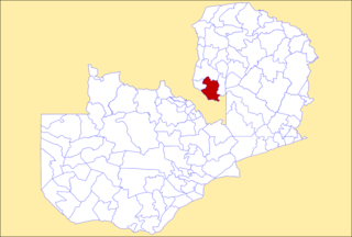
Mansa District with headquarters at Mansa is a district located in Luapula Province. As of the 2022 Zambian Census, the district had a population of 327,063 people. It consists of two constituencies, namely Mansa Central and Bahati.

Samfya District is located in Luapula Province, Zambia. The headquarters is at Samfya.

Lusaka District is a district of Zambia, located in Lusaka Province. The capital lies at Lusaka. As of the 2022 Zambian Census, the district had a population of 2,204,059 people.

Solwezi District is a district of Zambia, located in North-Western Province. The capital lies at Solwezi. As of the 2022 Zambian Census, the district had a population of 332,623 people.

Kawambwa District is a district of Zambia, located in Luapula Province. The capital lies at Kawambwa, which lies at the intersection of three roads: D19, M13, and Kawambwa-Mbereshi. As of the 2022 Zambian Census, the district had a population of 123,652 people. It consists of two constituencies, namely Kawambwa and Pambashe.

Mwense District is a district of Zambia, located in Luapula Province. The capital lies at Mwense. As of the 2022 Zambian Census, the district had a population of 122,605 people. It consists of two constituencies, namely Mwense and Mambilima.

Isoka District is a district of Zambia, located in Muchinga Province. The capital lies at Isoka. As of the 2022 Zambian Census, the district had a population of 111,599 people.

Muchinga Province is one of the ten provinces of Zambia. It is located in the northeast of the country and borders with Tanzania in the north, Malawi in the east, Eastern Province in the south, Central Province in the southwest, Luapula Province in the west, and Northern Province in the northwest. The administrative center of the province is Chinsali.

Chipili is a constituency of the National Assembly of Zambia. It covers the town of Chipili in Chipili District of Luapula Province.

Lunga District is a district in the Luapula Province of Zambia. It was declared a district in 2012 by Michael Sata. The district comprises archipelago of islands in the Bangweulu Wetlands in the south-east of Lake Bangweulu. As of the 2022 Zambian Census, the district had a population of 39,383 people.

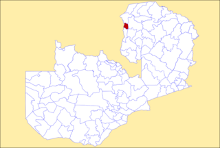
Chembe District is a district of Zambia, located in Luapula Province. The capital lies at Chembe. It was created in 2012 by splitting Mansa District. As of the 2022 Zambian Census, the district had a population of 51,532 people.

Sikongo District is a district of Zambia, located in Western Province. It was separated from Kalabo District in 2012. As of the 2022 Zambian Census, the district had a population of 59,670 people.

Chitambo District is a district of Central Province, Zambia. It was separated from Serenje District in 2012 and is located some 357km north-east of Kabwe along the Great North Road. As of the 2022 Zambian Census, the district had a population of 100,603 people.
Mwansabombwe District is a district of Luapula Province, Zambia. The seat of the district is Mwansabombwe. It was separated from Kawambwa District in 2012. As of the 2022 Zambian Census, the district had a population of 58,919 people.

Chifunabuli District is a district of Luapula Province, Zambia. It was created in 2018 by splitting Samfya District. As of the 2022 Zambian Census, the district had a population of 116,326 people.
The M13 is a road in the Luapula Province of Zambia that connects Chipili with Kawambwa.
