
Western Province is one of the 10 provinces in Zambia and encompasses most of the area formerly known as Barotseland. The capital is Mongu, and together with the neighbouring town of Limulunga, Mongu is treated as the capital of Barotseland.

The Kabompo River is one of the main tributaries of the upper Zambezi River. It flows entirely in Zambia, rising to the east of the source of the Zambezi, in North-Western Province along the watershed between the Zambezi and Congo river basins which also forms the border between Zambia and DR Congo. It is the second deepest river in Africa and one of the top five in the world.
Mwinilunga is a town in the North-Western Province of Zambia. It is the headquarters of Mwinilunga District, one of the province's eleven districts.
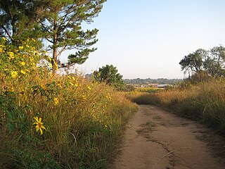
Kabompo is a town in north-western Zambia, lying on the Kabompo River with a population over 88,000 people. It is surrounded by teak forest and is home to a Roman Catholic mission. Kabompo was founded in the 1900s or even earlier than that, the district centre was first situated in Nkulwashi before it was moved to its current location. The district boasts of its significance towards its contribution to the nation's food security through Food Reserve Agency (FRA). Even in the late 60's and early 70's Kabompo was very active in agricultural activities through NAMBOARD.
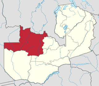
North-Western Province is one of ten Provinces of Zambia. It covers an area of 125,826 km2 (48,582 sq mi), has a population of 1,278,357 and a population density of 20 per square kilometre as of 2021. It is the most sparsely populated province in the country. The provincial capital is Solwezi. The literacy rate stood at 63 per cent in 2010 against a national average of 70.2 per cent. The rural population constituted 77.45%, while the urban population was 22.55%. North-Western Province is bordered along Angola in the west, the Democratic Republic of Congo in the north, Copperbelt Province in the east, Central in the south-east, and Western Province in the south-west.
This article gives lists of the National Monuments and other historic sites of Zambia, with a one- or two-line description providing links to details given on other pages.

Chama District with the headquarters at Chama is the largest district of the Eastern Province in Zambia and includes a large wilderness in the Upper Luangwa valley just north-east of the North Luangwa National Park. It is made up of two constituencies, namely Chama North and Chama South.

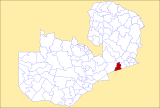
Mongu District is a district of Zambia with headquarters at Mongu. As of the 2000 Zambian Census, the district had a population of 162,002 people. More than a quarter of whom live in Mongu town; the remainder live on the floodplain or its edge. East of the Lui River, the population is very low due to the absence of surface water in the dry season.

Lukulu District is a district of Zambia, located in Western Province. The capital lies at Lukulu. As of the 2000 Zambian Census, the district had a population of 68,375 people.

Senanga District is a district of Zambia, located in Western Province. The capital lies at Senanga. As of the 2000 Zambian Census, the district had a population of 109,119 people.

Kitwe District is a district of Zambia, located in Copperbelt Province. The capital is Kitwe. As of the 2022 Zambian Census, the district had a population of 661,901 people.
Mufulira District is a district of Zambia, located in Copperbelt Province. The capital lies at Mufulira. As of the 2022 Zambian Census, the district had a population of 200,182 people. It is divided into three constituencies, namely Mufulira, Kantanshi and Kankoyo.
Choma District is a district of Zambia, located in Southern Province. The capital lies at Choma. As of the 2022 Zambian Census, the district had a population of 266,916 people. Choma has been the provincial capital of the Southern Province since 2012.

Monze District is a district of Zambia, located in Southern Province. The capital lies at Monze. As of the 2022 Zambian Census, the district had a population of 268,432 people.

Chipata District is a district of Zambia, located in Eastern Province. The capital lies at Chipata. As of the 2010 Zambian Census, the district had a population of 455,783 people.
Petauke District is a district of Zambia, located in Eastern Province. The capital lies at Petauke. As of the 2000 Zambian Census, the district had a population of 235,879 people. It consists of two constituencies, namely Petauke Central and Kaumbwe.

Mporokoso District is a district of Zambia, located in Northern Province. The capital lies at Mporokoso. As of the 2000 Zambian Census, the district had a population of 73,929 people.

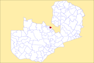
Manyinga District is a district of North-Western Province, Zambia. It was separated from Kabompo District in 2012.

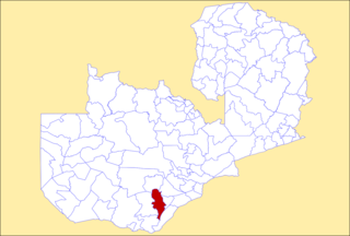
Kabompo is a constituency of the National Assembly of Zambia. It covers the towns of Chikonkwelo, Chilikita, Kabompo, Kabulamena, Kayombo, Mumbeji, Samiyengo and Shindola in Kabompo District of North-Western Province.
The M8 road is a road in the North-Western Province of Zambia. It connects Mutanda in with Zambezi Town via Mufumbwe, Manyinga & Kabompo.
