
Copperbelt Province is a province in Zambia which covers the mineral-rich Copperbelt, and farming and bush areas to the south. It was the backbone of the Northern Rhodesian economy during British colonial rule and fuelled the hopes of the immediate post-independence period, but its economic importance was severely damaged by a crash in global copper prices in 1973. The province adjoins the Haut-Katanga province of the Democratic Republic of the Congo, which is similarly mineral-rich.
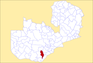
Siavonga is a town in the Southern Province of Zambia, lying on the north shore of Lake Kariba. It is Zambia's principal tourism centre for the lake, with accommodation, boating and fishing tours on offer.

Southern Province is one of Zambia's ten provinces. It is home to Zambia's premier tourist attraction, Mosi-oa-Tunya, shared with Zimbabwe. The centre of the province, the Southern Plateau, has the largest area of commercial farmland of any Zambian province, and produces most of the maize crop.

The ten provinces of Zambia are divided into a total of 116 districts as of 2018.

Chibombo District is a district of Central Province, Zambia. As of the 2022 Zambian Census, the district had a population of 421,315 people. It consists of two constituencies, namely Keembe and Katuba.

Kabwe District is a district of Zambia, located in Central Province. The capital lies at Kabwe. As of the 2010 Zambian Census, the district had a population of 299,206 people. It consists of two constituencies, namely Kabwe Central and Bwacha.

Kapiri Mposhi District is a district of Zambia, located in Central Province. The capital lies at Kapiri Mposhi. As of the 2022 Zambian Census, the district had a population of 371,068 people.

Kitwe District is a district of Zambia, located in Copperbelt Province. The capital is Kitwe. As of the 2000 Zambian Census, the district had a population of 376,124 people.

Ndola District is a district of Zambia, located in Copperbelt Province. The capital lies at Ndola. As of the 2000 Zambian Census, the district had a population of 374,757 people.

Chongwe District is a district of Zambia, located in Lusaka Province. The capital lies at Chongwe. As of the 2022 Zambian Census, the district had a population of 313,389 people.
Kafue District is a district of Zambia, located in Lusaka Province. The capital lies at Kafue. As of the 2022 Zambian Census, the district had a population of 219,574 people.
Choma District is a district of Zambia, located in Southern Province. The capital lies at Choma. As of the 2022 Zambian Census, the district had a population of 266,916 people. Choma has been the provincial capital of the Southern Province since 2012.

Gwembe District is a district of Zambia, located in Southern Province. The capital now lies at Munyumbwe. As of the 2022 Zambian Census, the district had a population of 79,273 people.

Mazabuka District is a district of Zambia, located in Southern Province. The capital lies at Mazabuka. As of the 2000 Zambian Census, the district had a population of 232,045 people.

Monze District is a district of Zambia, located in Southern Province. The capital lies at Monze. As of the 2022 Zambian Census, the district had a population of 268,432 people.

The T2 is a trunk road in Zambia. The road runs from the Tunduma border with Tanzania via Mpika, Kabwe and Lusaka to the Chirundu border with Zimbabwe. The road is the longest route of the country, as it is approximately 1,155 kilometres (718 mi). The route from Mpika to Kafue is a toll road. The route from Tanzania to Lusaka is Zambia's Great North Road and is part of the Tanzam Highway.

Chilanga District is a district of Lusaka Province, Zambia. The capital of the district is Chilanga. It was separated from Kafue District in 2012.

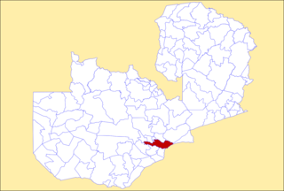
Chirundu District is a district of Southern Province, Zambia. Its headquarters is Chirundu. It was separated from Siavonga District by President Michael Sata in 2012.
Siavonga is a constituency of the National Assembly of Zambia. It covers Siavonga and surrounding areas in Siavonga District of Southern Province.
