Western Province is one of the 10 provinces in Zambia and encompasses most of the area formerly known as Barotseland. The capital is Mongu, and together with the neighbouring town of Limulunga, Mongu is treated as the capital of Barotseland.

Northern Province is one of Zambia's ten provinces. It covers approximately one-sixth of Zambia in land area. The provincial capital is Kasama. The province is made up of 12 districts, namely Kasama District, Chilubi District, Kaputa District, Luwingu District, Mbala District, Mporokoso District, Mpulungu District, Mungwi District, Nsama District, Lupososhi District, Lunte District and Senga Hill District. Currently, only Kasama and Mbala have attained municipal council status, while the rest are still district councils. It is widely considered to be the heartland of the Bemba, one of the largest tribes in Zambia.
Mwinilunga is a town in the North-Western Province of Zambia. It is the headquarters of Mwinilunga District, one of the province's eleven districts.

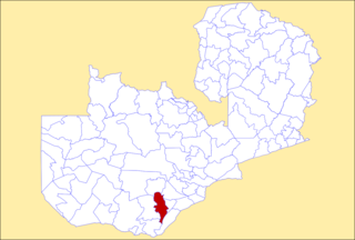
Mazabuka is a town in the Southern Province of Zambia. It is the capital of Mazabuka District, one of the thirteen administrative units in the Southern Province.

Central Province is one of Zambia's ten provinces. The provincial capital is Kabwe, which is the home of the Mulungushi Rock of Authority. Central Province has an area of 94,394 km (58,654 mi). It borders eight other provinces and has eleven districts. The total area of forest in the province is 9,095,566 ha, and it has a national park and three game management areas. The first mine in the region was opened up in 1905 making the then Broken Hill town the first mining town. In 1966, the town's name was reverted to its indigenous name - Kabwe meaning 'ore' or 'smelting'.

Eastern Province is one of Zambia's ten provinces. The province lies between the Luangwa River and borders with Malawi to the east and Mozambique to the south, from Isoka in the northeast to the north of Luangwa in the south. The provincial capital is Chipata. Eastern province has an area of 51,476 km2 (19,875 sq mi), locally shares border with three other provinces of the country and is divided into fifteen districts.

Luapula Province is one of Zambia's ten provinces located in the northern part of the country. Luapula Province is named after the Luapula River and its capital is Mansa. As per the 2022 Zambian census, the Province had a population of 1,519,478, which accounted for 7.72 per cent of the total Zambian population.

Lusaka Province is one of the ten provinces of Zambia. It is the smallest in terms of land area, covering 21,896 km2. However, it is the most populated and densely populated province in Zambia, with a population of 3,079,964 as of 2022 and a population density of 140 persons per km2.

The ten provinces of Zambia are divided into a total of 116 districts as of 2018.

Lusaka is the capital and largest city of Zambia. It is one of the fastest-developing cities in southern Africa. Lusaka is in the southern part of the central plateau at an elevation of about 1,279 metres (4,196 ft). As of 2019, the city's population was about 3.3 million, while the urban population is estimated at 2.5 million in 2018. Lusaka is the centre of both commerce and government in Zambia and connects to the country's four main highways heading north, south, east, and west. English is the official language of the city administration, while Bemba and Nyanja are the commonly spoken street languages.

Chongwe District is a district of Zambia, located in Lusaka Province. The capital lies at Chongwe. As of the 2022 Zambian Census, the district had a population of 313,389 people.
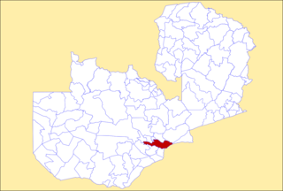
Kafue District is a district of Zambia, located in Lusaka Province. The capital lies at Kafue. As of the 2022 Zambian Census, the district had a population of 219,574 people.
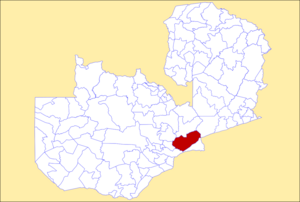
Choma District is a district of Zambia, located in Southern Province. The capital lies at Choma. As of the 2022 Zambian Census, the district had a population of 266,916 people. Choma has been the provincial capital of the Southern Province since 2012.

Itezhi-Tezhi District is a district of Zambia, located in Southern Province. The capital lies at Itezhi-Tezhi. As of the 2022 Zambian Census, the district had a population of 130,216 people.

General elections were held in Zambia on 20 September 2011, electing a President and members of the National Assembly. Michael Sata of the Patriotic Front (PF) won the presidential elections, defeating incumbent Rupiah Banda of the Movement for Multi-Party Democracy (MMD), and was sworn into office on 23 September. The PF emerged as the largest party in the National Assembly, winning 60 of the 148 seats decided on election day.

Muchinga Province is one of the ten provinces of Zambia. It is located in the northeast of the country and borders with Tanzania in the north, Malawi in the east, Eastern Province in the south, Central Province in the southwest, Luapula Province in the west, and Northern Province in the northwest. The administrative center of the province is Chinsali.

Sylvia Masebo is a Zambian entrepreneur, politician, and National Assembly of Zambia representative for Chongwe constituency with the United Party for National Development (UPND). Sylvia Masebo holds a degree in Banking and Finance. She first stood on the ticket of Zambian Republican Party (ZRP) in 2001, then the Movement for Multi-Party Democracy (MMD) in 2003, then the Patriotic Front (PF) in 2011, and then the UPND in 2021.
Senior Chieftainess Nkomeshya Mukamambo II is the chieftainship of the Soli people of Chongwe District in Lusaka Province. She has been a chieftainess in the area since 1976. She is the second female Nkomeshya since 19th century Mukamambo I who is mythologized as having spiritual powers that allowed her to change her physical form and veil her people to protect them from enemies.

Chisamba District is a district of Central Province, Zambia. It covers a total surface area of 5,204.5 sq km and is known for its agricultural activities with over 32,000 small scale farming families and 256 commercial farmers, the majority of whom are white Zambians. It shares borders with Lusaka, Chongwe, Chibombo, Kabwe, Kapiri Mposhi and Luano Districts. The District has a total population of 160,828.