Solwezi is a town in Zambia. It is the provincial capital of the mineral-rich North-Western Province. Solwezi is also the administrative capital of Solwezi District, one of the eleven districts in the North-Western Province.

Copperbelt Province is a province in Zambia which covers the mineral-rich Copperbelt, and farming and bush areas to the south. It was the backbone of the Northern Rhodesian economy during British colonial rule and fuelled the hopes of the immediate post-independence period, but its economic importance was severely damaged by a crash in global copper prices in 1973. The province adjoins the Haut-Katanga province of the Democratic Republic of the Congo, which is similarly mineral-rich.

Northern Province is one of Zambia's ten provinces. It covers approximately one-sixth of Zambia in land area. The provincial capital is Kasama. The province is made up of 12 districts, namely Kasama District, Chilubi District, Kaputa District, Luwingu District, Mbala District, Mporokoso District, Mpulungu District, Mungwi District, Nsama District, Lupososhi District, Lunte District and Senga Hill District. Currently, only Kasama and Mbala have attained municipal council status, while the rest are still district councils. It is widely considered to be the heartland of the Bemba, one of the largest tribes in Zambia.
Kasungu is a district in the Central Region of Malawi. The capital is Kasungu. The district covers an area of 7,878 km², borders Zambia and has a population of 842,953.

Eastern Province is one of Zambia's ten provinces. The province lies between the Luangwa River and borders with Malawi to the east and Mozambique to the south, from Isoka in the northeast to the north of Luangwa in the south. The provincial capital is Chipata. Eastern province has an area of 51,476 km2 (19,875 sq mi), locally shares border with three other provinces of the country and is divided into fifteen districts.

Lusaka Province is one of the ten provinces of Zambia. It is the smallest in terms of land area, covering 21,896 km2. However, it is the most populated and densely populated province in Zambia, with a population of 3,079,964 as of 2022 and a population density of 140 persons per km2.
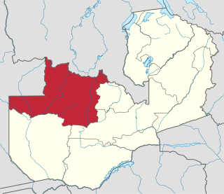
North-Western Province is one of ten Provinces of Zambia. It covers an area of 125,826 km2 (48,582 sq mi), has a population of 1,278,357 and a population density of 20 per square kilometre as of 2021. It is the most sparsely populated province in the country. The provincial capital is Solwezi. The literacy rate stood at 63 per cent in 2010 against a national average of 70.2 per cent. The rural population constituted 77.45%, while the urban population was 22.55%. North-Western Province is bordered along Angola in the west, the Democratic Republic of Congo in the north, Copperbelt Province in the east, Central in the south-east, and Western Province in the south-west.

Kabwe Central is a constituency of the National Assembly of Zambia. It covers part of Kabwe District in Central Province.

Mumbwa District is a district of Zambia, located in Central Province. The capital lies at Mumbwa. As of the 2022 Zambian Census, the district had a population of 332,237 people. It consists of two constituencies, being Mumbwa and Nangoma.

Lusaka District is a district of Zambia, located in Lusaka Province. The capital lies at Lusaka. As of the 2022 Zambian Census, the district had a population of 2,204,059 people.

Kalomo District is a district of Zambia, located in Southern Province. The capital lies at Kalomo. As of the 2022 Zambian census, the district had a population of 274,640 people.

Mwense District is a district of Zambia, located in Luapula Province. The capital lies at Mwense. As of the 2000 Zambian Census, the district had a population of 105,759 people. It consists of two constituencies, namely Mwense and Mambilima.
Mutanda is a town in Kalumbila District, North-Western Province, Zambia. It is approximately 33 kilometres (21 mi), by road, southwest of Solwezi. Mutanda is situated approximately 500 kilometres (310 mi), by road, northwest of Lusaka, the capital.

Muchinga Province is one of the ten provinces of Zambia. It is located in the northeast of the country and borders with Tanzania in the north, Malawi in the east, Eastern Province in the south, Central Province in the southwest, Luapula Province in the west, and Northern Province in the northwest. The administrative center of the province is Chinsali.
Mkushi South is a constituency of the National Assembly of Zambia. It covers the towns of Chafung, Chingobe and Mboroma in Luano District of Central Province.
Victoria Kalima Phiri was a Zambian politician who was Minister of Gender and member of the National Assembly for Kasenengwa from 2016 and 2011, respectively, till her death.
The T5 is a trunk road in Zambia. It connects Chingola in the Copperbelt Province with Solwezi and Mwinilunga in the North-Western Province. The route extends to end at the Jimbe border post with Angola. It is the only other road after the M18 road that connects the towns of the North-Western and Copperbelt provinces and is currently the main route motorists use to reach Angola from Zambia. The section of the road from Chingola to Mutanda is a toll road.
Solwezi Central is a constituency of the National Assembly of Zambia. It covers the towns of Kansanshi, Kulima and Solwezi in Solwezi District of North-Western Province.
Solwezi East is a constituency of the National Assembly of Zambia. It covers Mushindamo District of North-Western Province.
Solwezi West is a constituency of the National Assembly of Zambia. It covers the towns of Mayana, Mumena and Mutanda in Kalumbila District of North-Western Province.
