The Northern District is one of Israel's six administrative districts. The Northern District has a land area of 3,324 km2, making it the second largest district in Israel. The district capital is Nof HaGalil and the largest city is Nazareth.

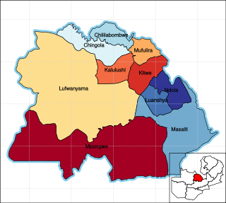
Copperbelt Province is a province in Zambia which covers the mineral-rich Copperbelt, and farming and bush areas to the south. It was the backbone of the Northern Rhodesian economy during British colonial rule and fuelled the hopes of the immediate post-independence period, but its economic importance was severely damaged by a crash in global copper prices in 1973. The province adjoins the Haut-Katanga province of the Democratic Republic of the Congo, which is similarly mineral-rich.
Chililabombwe is a small town in Copperbelt Province, Zambia. It is located near the Democratic Republic of the Congo border. The name Chililabombwe means 'place of the croaking frog' in the local language of Lamba. The town has a population of 87 000 based on census data from 2010, making it one of the largest towns in the Copperbelt. The town is on the T3 road, 26 km north of the neighbouring town of Chingola, and approximately 10 km south of the large border market of Kasumbalesa. It has also produced national heroes like the late soccer star Eston Mulenga and many others.
Antambolo or Amboasary-Antambolo is a town and commune in Madagascar. It belongs to the district of Arivonimamo, which is a part of Itasy Region. The population of the commune was estimated to be approximately 4,000 in 2001 commune census.

Chama District with the headquarters at Chama is the largest district of the Eastern Province in Zambia and includes a large wilderness in the Upper Luangwa valley just north-east of the North Luangwa National Park. It is made up of two constituencies, namely Chama North and Chama South.

Chibombo District is a district of Central Province, Zambia. As of the 2022 Zambian Census, the district had a population of 421,315 people. It consists of two constituencies, namely Keembe and Katuba.

Kaoma District with headquarters at Kaoma, Zambia is located in the north-east corner of Western Province. As of the 2000 Zambian Census, the district had a population of 162,568 people. The population lives mainly around Kaoma town and the northern parts of the district along the Luena and Luampa Rivers. Its south-western portion is relatively uninhabited being very sandy with little water available in the dry season.

Lukulu District is a district of Zambia, located in Western Province. The capital lies at Lukulu. As of the 2000 Zambian Census, the district had a population of 68,375 people.

Sesheke District is one of the sixteen (16) districts in Western Province of Zambia. Lying 300km south of the provincial capital, Mongu and 190km from Livingstone, the nations tourist capital, the district shares borders with Sioma in the west, Senanga and Mulobezi in the north-east and Mwandi in the east. The district also shares international border with Namibia south and Angola in south-west. The capital lies at Sesheke. As of the 2000 Zambian Census, the district had a population of 78,169 people. It contains Sioma Ngwezi National Park and contains part of the Zambezi River, which forms Zambia's border with Namibia.

Kabwe District is a district of Zambia, located in Central Province. The capital lies at Kabwe. As of the 2010 Zambian Census, the district had a population of 299,206 people. It consists of two constituencies, namely Kabwe Central and Bwacha.

Chingola District is a district of Zambia, located in Copperbelt Province. The capital lies at Chingola. As of the 2022 Zambian Census, the district had a population of 299,936 people. It is divided into two constituencies, namely Chingola constituency and Nchanga constituency.

Luanshya District is a district of Zambia, located in Copperbelt Province. The capital lies at Luanshya. As of the 2022 Zambian census, the district had a population of 211,966 people.

Ndola District is a district of Zambia, located in Copperbelt Province. The capital lies at Ndola. As of the 2022 Zambian Census, the district had a population of 624,579 people.

Kasempa District is a district of Zambia, located in North-Western Province. The capital lies at Kasempa. As of the 2022 Zambian Census, the district had a population of 111,272 people.

Livingstone District is a district of Zambia, located in Southern Province. The capital lies at Livingstone. As of the 2022 Zambian Census, the district had a population of 177,393 people. Its border with Zimbabwe is formed by the Zambezi River and Victoria Falls. Although most people live in Livingstone, other villages include Jinga Jinga in the north and Simonga in the southwest.

Kawambwa District is a district of Zambia, located in Luapula Province. The capital lies at Kawambwa, which lies at the intersection of three roads: D19, M13, and Kawambwa-Mbereshi. The Luapula River forms its boundary with the Democratic Republic of the Congo. As of the 2000 Zambian Census, the district had a population of 102,503 people. It consists of two constituencies, namely Kawambwa and Pambashe.

Kaputa District is a district of Zambia, located in Northern Province. The capital lies at Kaputa. As of the 2000 Zambian Census, the district had a population of 87,233 people.

Luwingu District is a district of Zambia, located in Northern Province. The capital lies at Luwingu. As of the 2000 Zambian Census, the district had a population of 80,758 people.

Chisamba District is a district of Central Province, Zambia. It covers a total surface area of 5,204.5 sq km and is known for its agricultural activities with over 32,000 small scale farming families and 256 commercial farmers, the majority of whom are white Zambians. It shares borders with Lusaka, Chongwe, Chibombo, Kabwe, Kapiri Mposhi and Luano Districts. The District has a total population of 160,828.
Kasumbalesa is a town in Zambia that sits across the international border from the much larger town of Kasumbalesa, Democratic Republic of the Congo. It is a major crossing point for human traffic and cargo between the two countries.


