This article ia about the transport in Zambia.

The Luangwa River is one of the major tributaries of the Zambezi River, and one of the four biggest rivers of Zambia. The river generally floods in the rainy season and then falls considerably in the dry season. It is one of the biggest unaltered rivers in Southern Africa and the 52,000 square kilometres (20,000 sq mi) that make up the surrounding valley are home to abundant wildlife.

Northern Province is one of Zambia's ten provinces. It covers approximately one sixth of Zambia in land area. The provincial capital is Kasama. The province is made up of 12 districts, namely Kasama District, Chilubi District, Kaputa District, Luwingu District, Mbala District, Mporokoso District, Mpulungu District, Mungwi District, Nsama District, Lupososhi District, Lunte District and Senga Hill District. Currently, only Kasama and Mbala have attained municipal council status, while the rest are still district councils. It is widely considered to be the heartland of the Bemba, one of the largest tribes in Zambia.

South Luangwa National Park in eastern Zambia, the southernmost of three national parks in the valley of the Luangwa River. It, is a world-renowned wildlife haven. It is simply know to locals simply as "the South Park."Concentrations of game along the meandering Luangwa River and its lagoons are amongst the most intense in Africa. The river teems with hippo and crocodile and provides a lifeline for one of the greatest diversities of habitat and wildlife, supporting more than 60 species of mammals and over 400 species of birds.It marks the end of the Great Rift Valley.

Mpika is a town in the Muchinga Province of Zambia, lying at the junction of the Great North Road to Kasama and Mbala and the Tanzam Highway to Dar es Salaam, Tanzania. It also has a railway station on the TAZARA Railway about 5 km away. Mpika is situated between the Muchinga Escarpment to the east and vast miombo plains to the west. The town has an estimated population of 40,000 inhabitants (2008), while the district population is estimated 150,000 inhabitants. Since Mpika District was the biggest district in Zambia before its division in 2017, the population density was less than 4 people per square kilometre.

The Great East Road is a major road in Zambia and the main route linking its Eastern Province with the rest of the country. It is also the major link between Zambia and Malawi and between Zambia and northern Mozambique. However, the route does not carry as much traffic as many of the other regional arterial roads and between the main cities it serves, Lusaka and Chipata, it passes through rural and wilderness areas. In Lusaka the road forms the main arterial road for the eastern suburbs. The entire route from Lusaka to Chipata and the Malawi Border Post is designated the T4 Highway.

Central Province is one of Zambia's ten provinces. The provincial capital is Kabwe, which is the home of the Mulungushi Rock of Authority. Central Province has an area of 94,394 km (58,654 mi). It borders eight other provinces and has twelve districts. The total area of forest in the province is 9,095,566 ha, and it has a national park and three game management areas. The first mine in the region was opened up in 1905 making the then Broken Hill town the first mining town. In 1966, he town's name was reverted to its indigenous name - Kabwe meaning 'ore' or 'smelting'.

Eastern Province is one of Zambia's ten provinces. The province lies between the Luangwa River and borders with Malawi to the east and Mozambique to the south, from Isoka in the northeast to the north of Luangwa in the south. The provincial capital is Chipata. Eastern province has an area of 51,476 km2 (19,875 sq mi), locally shares border with three other provinces of the country and is divided into eleven districts.

Lusaka Province is one of the ten provinces of Zambia. Its capital is Lusaka, which is also the national capital. It is the smallest province in Zambia, with an area of 21,896 km2. Lusaka is also Zambia's most populated and most densely populated province, with a population of 2,191,225 and density of 100 persons per km2 as of 2010. It is the most urban province, with the most doctors and fewest malaria-related incidents. The province is bordered by Zimbabwe and Mozambique, and separated by the Lower Zambezi National Park.

The ten provinces of Zambia are divided into a total of 117 districts as of 2018.
This article gives lists of the National Monuments and other historic sites of Zambia, with a one- or two-line description providing links to details given on other pages.

Luangwa is a town in Zambia, at the confluence of the Luangwa and Zambezi Rivers, which was called Feira until 1964. It is headquarters of a district of the same name in Lusaka Province.

The following outline is provided as an overview of and topical guide to Zambia:
Zambia, officially known as the Republic of Zambia, is a landlocked country in Southern Africa. The neighbouring countries are the Democratic Republic of the Congo to the north, Tanzania to the north-east, Malawi to the east, Mozambique, Zimbabwe, Botswana, and Namibia to the south, and Angola to the west. The capital city is Lusaka, located in the southeast of the country. The population is concentrated mainly around the capital and the Copperbelt to the northwest.

Chama District with the headquarters at Chama is the largest and least-populated district of the Muchinga Province in Zambia and includes a large wilderness in the Upper Luangwa valley just north-east of the North Luangwa National Park. The Chama District was formerly part of the Eastern Province.

Chinsali District with headquarters at Chinsali is located in Muchinga Province, Zambia.

Katete District with headquarters at Katete in Eastern Province, Zambia, includes woodland in the north sloping down into the Luangwa Valley, good farmland amid rocky hills in the centre, and deforested plateau exposed to soil erosion and degradation in the south along the border with Mozambique. As of the 2000 Zambian Census, the district had a population of 189,250 people.

Luangwa District is a district of Zambia, located in Lusaka Province. As of the 2020 Zambian Census, the district had a population of 31,007 people.
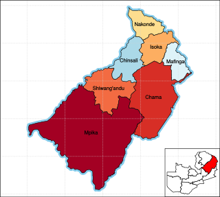
Muchinga Province is one of the ten provinces of Zambia. It is located in the northeast of the country and borders with Tanzania in the north, Malawi in the east, Eastern Province in the south, Central Province in the southwest, Luapula Province in the west, and Northern Province in the northwest. The administrative center of the province is Chinsali.
