
Copperbelt Province is a province in Zambia which covers the mineral-rich Copperbelt, and farming and bush areas to the south. It was the backbone of the Northern Rhodesian economy during British colonial rule and fuelled the hopes of the immediate post-independence period, but its economic importance was severely damaged by a crash in global copper prices in 1973. The province adjoins the Haut-Katanga province of the Democratic Republic of the Congo, which is similarly mineral-rich.

Central Province is one of Zambia's ten provinces. The provincial capital is Kabwe, which is the home of the Mulungushi Rock of Authority. Central Province has an area of 94,394 km (58,654 mi). It borders eight other provinces and has eleven districts. The total area of forest in the province is 9,095,566 ha, and it has a national park and three game management areas. The first mine in the region was opened up in 1905 making the then Broken Hill town the first mining town. In 1966, the town's name was reverted to its indigenous name - Kabwe meaning 'ore' or 'smelting'.

Chadiza District with the headquarters at Chadiza lies in the extreme south-east corner of Zambia, bordering Mozambique to its south. The eastern half of the district is characterised by wooded rocky hills rising to 1330 m while the western half has the same character as the land around Chadiza town. This part of the district has been almost completely deforested and suffers soil erosion. In 2012, most of the eastern part of the district was declared its own district, namely Vubwi District.

Kalabo District is a district of Zambia, located in Western Province. The capital lies at Kalabo. As of the 2022 Zambian Census, the district had a population of 111,769 people. The district contains the Liuwa Plain National Park.

Chipata District is a district of Zambia, located in Eastern Province. The capital lies at Chipata. As of the 2022 Zambian Census, the district had a population of 327,059 people.

Muchinga Province is one of the ten provinces of Zambia. It is located in the northeast of the country and borders with Tanzania in the north, Malawi in the east, Eastern Province in the south, Central Province in the southwest, Luapula Province in the west, and Northern Province in the northwest. The administrative center of the province is Chinsali.

Lunga District is a district in the Luapula Province of Zambia. It was declared a district in 2012 by Michael Sata. The district comprises archipelago of islands in the Bangweulu Wetlands in the south-east of Lake Bangweulu. As of the 2022 Zambian Census, the district had a population of 39,383 people.

The Vubwi District is a district of Zambia, located in the Eastern Province. It was separated from Chadiza District in 2012. As of the 2022 Zambian Census, the district had a population of 53,080 people.

Limulunga District is a district of Zambia, located in Western Province. The seat of the district is Limulunga. It was made independent from Mongu District in 2012. As of the 2022 Zambian Census, the district had a population of 61,102 people.

Mitete District is a district of Zambia, located in Western Province. It was separated from Lukulu District in 2012. As of the 2022 Zambian Census, the district had a population of 39,641 people.
Mulobezi District is a district of Zambia, located in Western Province. It was separated from Sesheke District in 2013. As of the 2022 Zambian Census, the district had a population of 45,326 people.
Mwandi District is a district of Zambia, located in Western Province. The capital lies at Mwandi. It was separated from Sesheke District in 2012. As of the 2022 Zambian Census, the district had a population of 40,418 people.

Nalolo District is a district of Zambia, located in Western Province. It was separated from Senanga District in 2012. As of the 2022 Zambian Census, the district had a population of 73,645 people.

Sikongo District is a district of Zambia, located in Western Province. It was separated from Kalabo District in 2012. As of the 2022 Zambian Census, the district had a population of 59,670 people.

Sioma District is a district of Zambia, located in Western Province on the west bank of the Zambezi River. The capital lies at Sioma. As of the 2022 Zambian Census, the district had a population of 65,539 people.

Chitambo District is a district of Central Province, Zambia. It was separated from Serenje District in 2012 and is located some 357km north-east of Kabwe along the Great North Road. As of the 2022 Zambian Census, the district had a population of 100,603 people.

Luano District is a district of Central Province, Zambia. It was separated from Mkushi District in 2012. As of the 2022 Zambian Census, the district had a population of 66,679 people.

Ngabwe District is a district of Central Province, Zambia. It was separated from Kapiri Mposhi District in 2012. As of the 2022 Zambian Census, the district had a population of 42,104 people.

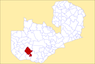
Chirundu District is a district of Southern Province, Zambia. Its headquarters is Chirundu. It was separated from Siavonga District by President Michael Sata in 2012. As of the 2022 Zambian Census, the district had a population of 78,780 people.

Manyinga District is a district of North-Western Province, Zambia. It was separated from Kabompo District in 2012. As of the 2022 Zambian Census, the district had a population of 75,030 people.
