Cabo Delgado is the northernmost province of Mozambique. It has an area of 82,625 km2 (31,902 sq mi) and a population of 2,320,261 (2017). As well as bordering Mtwara Region in the neighboring country of Tanzania, it borders the provinces of Nampula and Niassa. The region is an ethnic stronghold of the Makonde tribe, with the Makua and Mwani as leading ethnic minorities.

Southern Province is one of Zambia's ten provinces. It is home to Zambia's premier tourist attraction, Mosi-oa-Tunya, shared with Zimbabwe. The centre of the province, the Southern Plateau, has the largest area of commercial farmland of any Zambian province, and produces most of the maize crop.

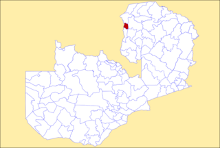
The ten provinces of Zambia are divided into a total of 116 districts as of 2018.

Kaoma District with headquarters at Kaoma, Zambia is located in the north-eastern corner of Western Province. As of the 2022 Zambian Census, the district had a population of 146,690 people. The population lives mainly around Kaoma town and the northern parts of the district along the Luena and Luampa rivers. Its south-western portion is relatively uninhabited being very sandy with little water available in the dry season.
Kalulushi District is a district of Zambia, located in Copperbelt Province. The capital lies at Kalulushi. As of the 2022 Zambian Census, the district had a population of 170,701 people.
Choma District is a district of Zambia, located in Southern Province. The capital lies at Choma. As of the 2022 Zambian Census, the district had a population of 266,916 people. Choma has been the provincial capital of the Southern Province since 2012.

Livingstone District is a district of Zambia, located in Southern Province. The capital lies at Livingstone. As of the 2022 Zambian Census, the district had a population of 177,393 people. Its border with Zimbabwe is formed by the Zambezi River and Victoria Falls. Although most people live in Livingstone, other villages include Jinga Jinga in the north and Simonga in the southwest.

Mporokoso District is a district of Zambia, located in Northern Province. The capital lies at Mporokoso. As of the 2022 Zambian Census, the district had a population of 63,452 people.

Rufunsa District is a district in Zambia, located in Lusaka Province. The district capital is Rufunsa. The district was established by President Michael Sata in 2012 by splitting Chongwe District. As of the 2022 Zambian census, it has a population of 81,733.

Limulunga District is a district of Zambia, located in Western Province. The seat of the district is Limulunga. It was made independent from Mongu District in 2012. As of the 2022 Zambian Census, the district had a population of 61,102 people.
Luampa District is a district of Zambia, located in Western Province. It was separated from Kaoma District in 2012. As of the 2022 Zambian Census, the district had a population of 61,023 people.

Nalolo District is a district of Zambia, located in Western Province. It was separated from Senanga District in 2012. As of the 2022 Zambian Census, the district had a population of 73,645 people.

Sioma District is a district of Zambia, located in Western Province on the west bank of the Zambezi River. The capital lies at Sioma. As of the 2022 Zambian Census, the district had a population of 65,539 people.

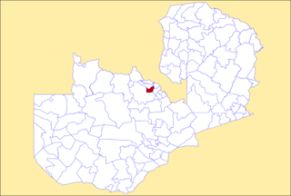
Ngabwe District is a district of Central Province, Zambia. It was separated from Kapiri Mposhi District in 2012. As of the 2022 Zambian Census, the district had a population of 42,104 people.
Mwansabombwe District is a district of Luapula Province, Zambia. The seat of the district is Mwansabombwe. It was separated from Kawambwa District in 2012. As of the 2022 Zambian Census, the district had a population of 58,919 people.

Chilanga District is a district of Lusaka Province, Zambia. The capital of the district is Chilanga. It was separated from Kafue District in 2012. As of the 2022 Zambian Census, the district had a population of 225,276 people.

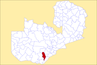
Chirundu District is a district of Southern Province, Zambia. Its headquarters is Chirundu. It was separated from Siavonga District by President Michael Sata in 2012. As of the 2022 Zambian Census, the district had a population of 78,780 people.

Shibuyunji District, also known as Sibuyunji District, is a district of Central Province, Zambia. As of the 2022 Zambian Census, the district had a population of 91,616 people.

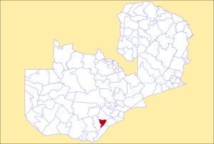
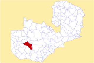
Chikankata District is a district of Southern Province, Zambia. It was separated from Mazabuka District in December 2011. As of the 2022 Zambian Census, the district had a population of 98,671 people.

Nkeyema District is a district of Western Province, Zambia. It was separated from Kaoma District in 2012. As of the 2022 Zambian Census, the district had a population of 106,074 people.